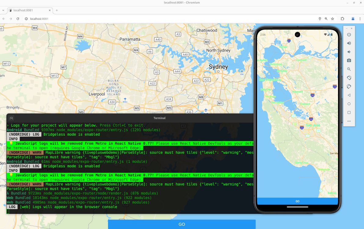
I've been dabbling of late in building a mobile app with React Native + Expo. One of the things that attracted me most to Expo, is that – on top of the "write once, run on iOS and Android" claim of React Native – Expo claims to also let an app run seamlessly on the web. Anyway, as it turns out (surprise surprise – not!), neither of those claims are particularly aligned with reality. I found this out – with the claim of "run on native and web" – as soon as I wanted to add a simple map to my app.
Behold, a MapLibre map, working both for native and for web, in Expo.
Below is my humble lil' guide to getting MapLibre working for both native and web in Expo. Note: if you want to skip the step-by-step shpiel, and you just want a working example with all the code, feel free to head straight to the Expo MapLibre native + web demo on GitHub.
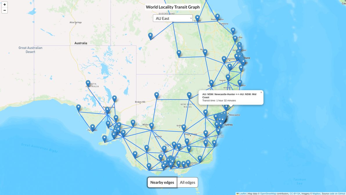
I built a dataset and map visualisation called the World Locality Transit Graph. Source code is on GitHub. It's a map of approximate transit times between any two given localities in various parts of the world.
World Locality Transit Graph showing the dataset for Eastern Australia
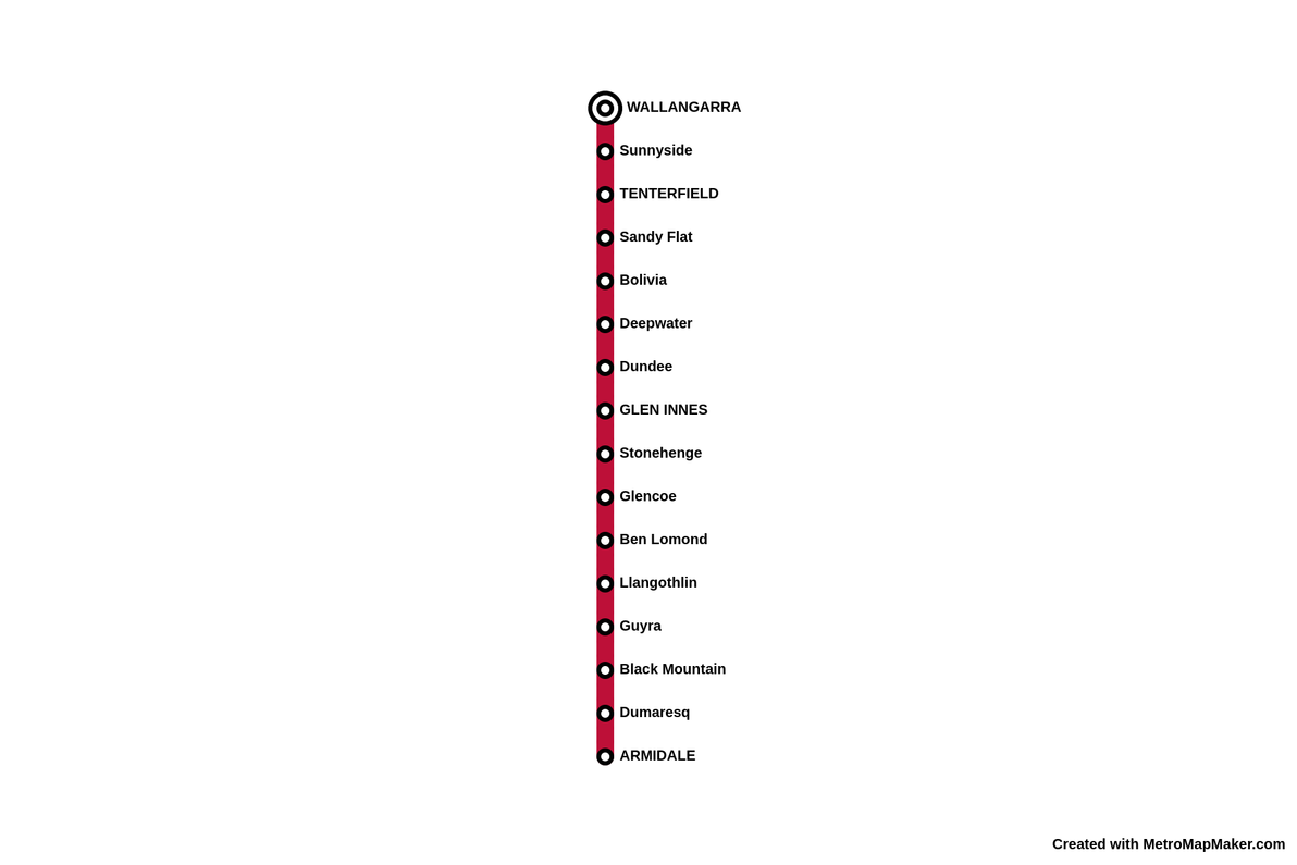
Running more-or-less alongside the most remote section of the New England Highway, through the Northern Tablelands region of NSW, can be found the remnants of a once-proud train line. The Great Northern Railway, as it was known in its heyday, provided the only railway service linking Sydney and Brisbane, between 1889 and 1930. Regular passenger services continued until 1972, and the line has been completely closed since 1988.
Metro map style illustration of the old Armidale to Wallangarra passenger service Thanks to:Metro Map Maker
Although I once drove through most of the Northern Tablelands, I wasn't aware of this railway, nor of its sad recent history, at the time. I just stumbled across it a few days ago, browsing maps online. I decided to pen this here wee thought, mainly because I was surprised at how scant information there is about the old line and its stations.
Most countries have one city which is clearly top of the pops. In particular, one city (which may not necessarily be the national capital) is usually the largest population centre and the main economic powerhouse of a given country. Humbly presented here is a quick and not-overly-scientific list of ten countries that are an exception to this rule. That is, countries where two cities (or more!) vie neck-and-neck for the coveted top spot.
Note: all population statistics are the latest numbers on relevant country- or city-level Wikipedia pages, as of writing, and all are for the cities' metropolitan area or closest available equivalent.
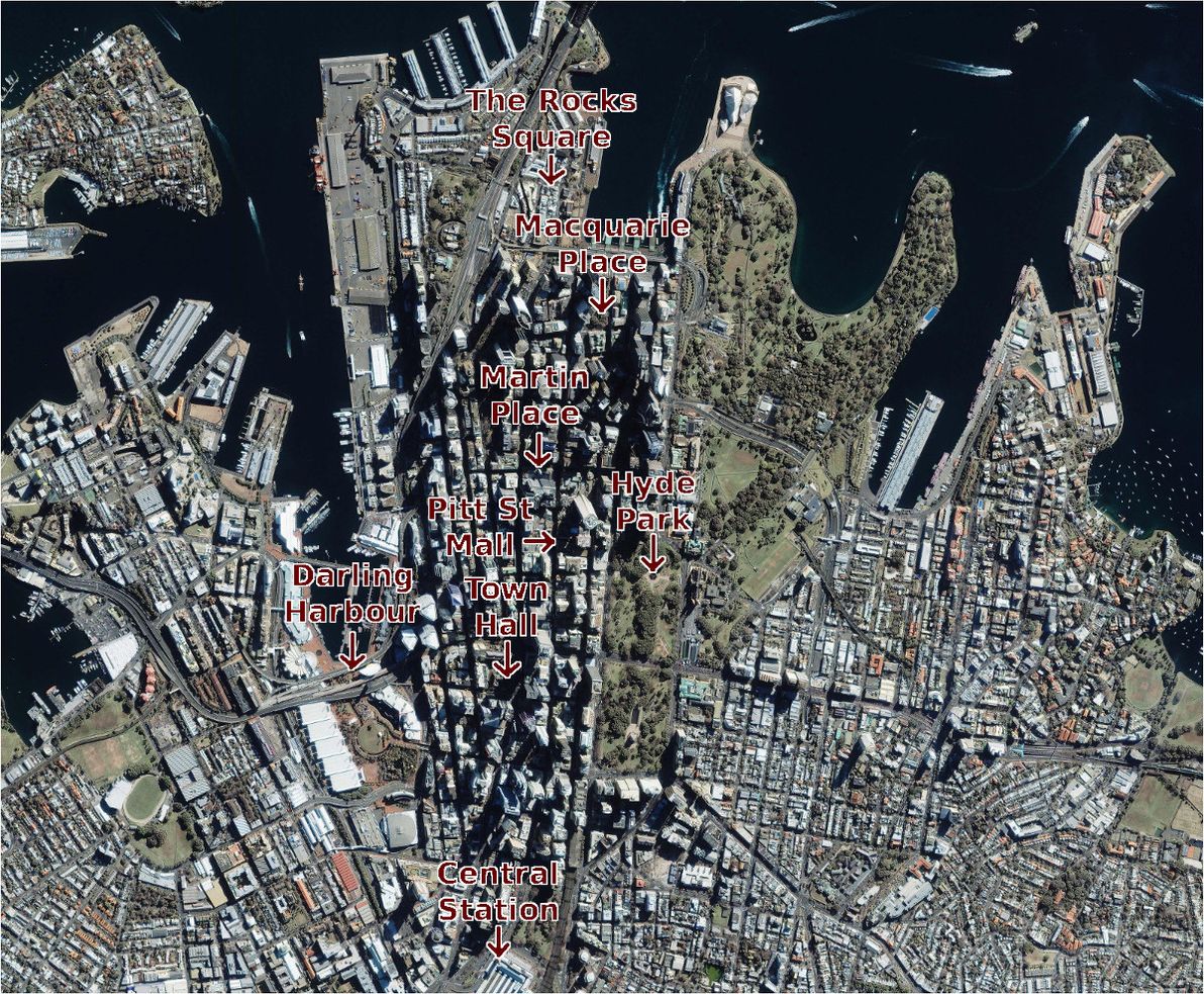
There are several different ways of commonly identifying the "official centre point" of a city. However, there's little international consensus as to the definition of such a point, and in many countries and cities the definition is quite vague.
Most reliable and most common, is to declare a Kilometre Zero marker as a city's (and often a region's or even a country's) official centre. Also popular is the use of a central post office for this purpose. Other traditional centre points include a city's cathedral, its main railway station, its main clock tower (which may be atop the post office / cathedral / railway station), its tallest building, its central square, its seat of government, its main park, its most famous tourist landmark, or the historical spot at which the city was founded.
Satellite photo of Sydney CBD, annotated with locations of "official centre" candidates. Image source:Satellite Imaging Corp.
My home town of Sydney, Australia, is one of a number of cities worldwide that boasts most of the above landmarks, but all in different locations, and without any mandated rule as to which of them constitutes the official city centre. So, where exactly in Sydney does X mark the spot?
For a recent project, I needed to know the LGAs (Local Government Areas) of all postcodes in Australia, and vice versa. As it turns out, there is no definitive Australia-wide list containing this data anywhere. People have been discussing the issue for some time, with no clear outcome. So, I decided to get creative.
If you want the full story: I imported both the LGA boundaries data and the Postal Area boundaries data from the ABS, into PostGIS, and I did an "Intersects" query on the two datasets. I exported the results of this query to CSV. Done! And all perfectly reproducible, using freely available public data sets, and using free and open-source software tools.
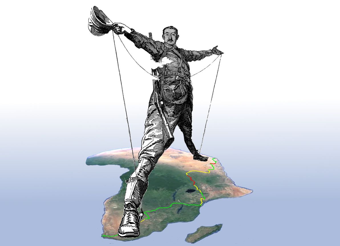
In the late 19th century, the British-South-African personality Cecil Rhodes dreamed of a complete, uninterrupted railway stretching from Cape Town, South Africa, all the way to Cairo, Egypt. During Rhodes's lifetime, the railway extended as far north as modern-day Zimbabwe – which was in that era known by its colonial name Rhodesia (in honour of Rhodes, whose statesmanship and entrepreneurism made its founding possible). A railway traversing the entire north-south length of Africa was an ambitious dream, for an ambitious man.
Rhodes's dream remains unfulfilled to this day.
The famous "Rhodes Colossus", superimposed upon the present-day route of the Cape to Cairo Railway. "The Rhodes Colossus" illustration originally from Punch magazine, Vol. 103, 10 Dec 1892; image courtesy of Wikimedia Commons. Africa satellite image courtesy of Google Earth.
Nevertheless, significant additions have been made to Africa's rail network during the interluding century; and, in fact, only a surprisingly small section of the Cape to Cairo route remains bereft of the Iron Horse's footprint.
Although both information about – (a) the historical Cape to Cairo dream; and (b) the history / current state of the route's various railway segments – abound, I was unable to find any comprehensive study of the current state of the railway in its entirety.
This article, therefore, is an endeavour to examine the current state of the full Cape to Cairo Railway. As part of this study, I've prepared a detailed map of the route, which marks in-service sections, abandoned sections, and missing sections. The map has been generated from a series of KML files, which I've made publicly available on GitHub, and for which I welcome contributions in the form of corrections / tweaks to the route.
Every now and again, Mother Nature reminds us that despite all of our modern technological and cultural progress, we remain mere mortals, vulnerable as always to her wrath. Human lives and human infrastructure continue to regularly fall victim to natural disasters such as floods, storms, fires, earthquakes, tsunamis, and droughts. At times, these catastrophes can even strike indiscriminately at our largest and most heavily-populated cities, including where we least expect them.
This article is a listing and an analysis of the world's largest cities (those with a population exceeding 10 million), and of their natural disaster risk level in a variety of categories. My list includes 23 cities, which represent a combined population of approximately 380 million people. That's roughly 5% of the world's population. Listing and population figures based on Wikipedia's list of metropolitan areas by population.
Per the laws of kashrut, the Jewish religion prohibits the consumption of meat from many animals and birds. Islam's laws of halal enact very similar prohibitions.
Australia and New Zealand are two countries located very far from the Middle East, the home of Judaism and Islam. Their native wildlife is completely different to that found anywhere else in the world. Of course, since European settlement began, they've been thoroughly introduced to the fauna of the wider world. Indeed, these two countries are today famous for being home to some of the world's largest sheep and cattle populations.
However, let's put aside the present-day situation for now, and take ourselves back in time a thousand or so years. Artificial transcontinental animal transportation has not yet begun. The world's animals still live in the regions that G-d ordained for them to live in. G-d has peppered almost every corner of the globe with at least some variety of kosher birds and mammals. Every major world region, bar one.
My fellow Aussies and Kiwis, I'm afraid the verdict is clear: we are living in the Land that G-d forgot.
I've spent a fair bit of time, on several occasions, travelling in South America, including in Chile and Argentina. I've crossed the land border between these two countries several times, in several different places. It's an extremely long border, measuring 5,308km in total.
Recently, I was looking for a list of all the official crossings between the two countries. Finding such a list, in clear and authoritative form, proved more difficult than I expected. Hence, one thing led to another; and before I knew it, I'd embarked upon a serious research mission to develop such a list myself. So, here it is — a list of all highway border crossings between Chile and Argentina, that are open to the general public.