Highway border crossings between Chile and Argentina
I've spent a fair bit of time, on several occasions, travelling in South America, including in Chile and Argentina. I've crossed the land border between these two countries several times, in several different places. It's an extremely long border, measuring 5,308km in total.
Recently, I was looking for a list of all the official crossings between the two countries. Finding such a list, in clear and authoritative form, proved more difficult than I expected. Hence, one thing led to another; and before I knew it, I'd embarked upon a serious research mission to develop such a list myself. So, here it is — a list of all highway border crossings between Chile and Argentina, that are open to the general public.
Note: there's a legend at the end of the article.
Northern crossings
The northern part of the Chile-Argentina frontier is generally hot, dry, and slightly flatter at the top. I found the frontier's northern crossings to be the best-documented, and hence the easiest to research. They're also generally the easiest crossings to make, as they pose the least risk of being impassable due to snowstorms.
Of the northern crossings, the only one I've travelled on is Paso Jama; although I didn't go through the pass itself, I crossed into Chile from Laguna Verde in Bolivia, and cut into the Chilean part of the highway from there (as part of a 4WD tour of the Salar de Uyuni).
Chilean regions: II (Antofagasta), III (Atacama).
Argentine provinces: Jujuy, Salta, Catamarca, La Rioja.
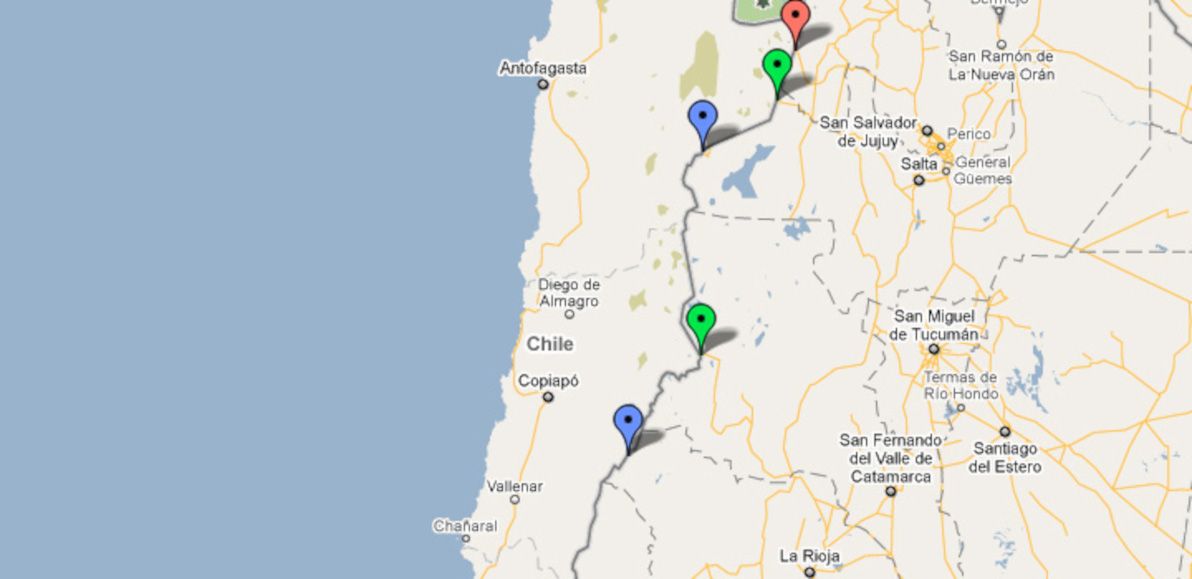
| Name | Route | Type | Notes |
|---|---|---|---|
| Paso Jama | S.P. de Atacama - S.S. de Jujuy | Main highway | |
| Paso Sico | Antofagasta - Salta | Secondary highway | |
| Paso Socompa | Antofagasta - Salta | Minor highway | |
| Paso San Francisco | Copiacó - S.F.V. de Catamarca | Secondary highway | |
| Paso Pircas Negras | Copiacó - La Rioja | Minor highway |
Central crossings
The Central part of the frontier is the most frequently crossed, as it's where you'll find the most direct route from Santiago to Buenos Aires. Unfortunately, Paso Los Libertadores is the only high-quality road in this entire section of the frontier — the mountains are particularly high, and construction of passes is particularly challenging, around here. After all, Aconcagua (the highest mountain in all the Americas) can be clearly seen right next to the main road.
As such, Los Libertadores is an extremely busy pass year-round; this is exacerbated by snowstorms forcing the pass to close during the height of winter, and also occasionally even in summer (despite there being a tunnel under the highest point of the route). I've travelled Los Libertadores twice (once in each direction), and it's a route with beautiful scenery; the zig-zags down the precipitous Chilean side of the pass are also quite hair-raising.
Chilean regions: IV (Coquimbo), V (Valparaíso).
Argentine provinces: San Juan, Mendoza.
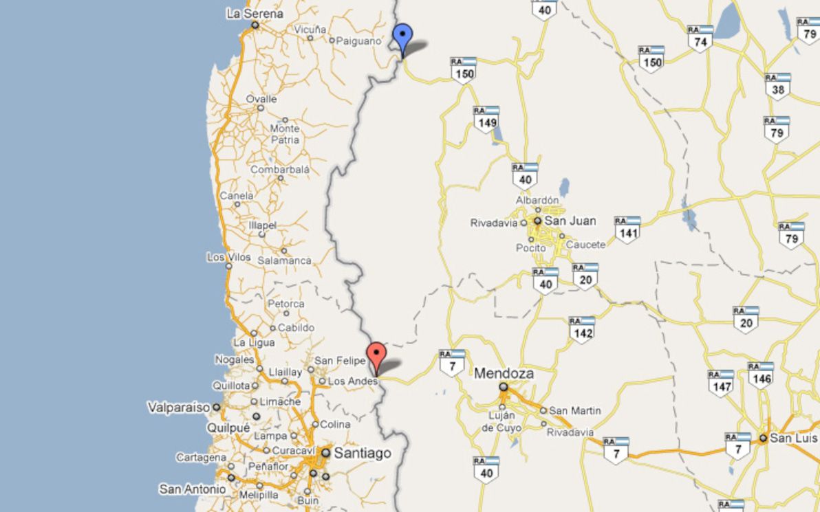
| Name | Route | Type | Notes |
|---|---|---|---|
| Paso Agua Negra | La Serena - San Juan | Minor highway | |
| Paso Los Libertadores | Santiago - Mendoza | Main highway |
Lake district crossings
The lake districts of both Chile and Argentina are famed for their "Swiss Alps of the South" picturesque beauty, and the border crossings in this area are among the most spectacular of all vistas that the region has to offer. There are numerous border crossings in this area, most of which are quite good roads, and two of which are highway-grade.
Paso Cardenal Antonio Samoré is the only one down here that I've crossed. The roads here are all liable to close due to snow conditions; although I was lucky enough to cross in September with no problems.
I should also note that I've explicitly excluded the famous and beautiful Paso Pérez Rosales (Puerto Montt - S.C. de Bariloche) from the list here: this is because, although it's a paved highway-grade road the whole way, the highway is interrupted by a (long) lake crossing. I'm only including on this list crossings that can be made in one complete, uninterrupted land vehicle journey.
Chilean regions: VIII (Biobío), IX (Araucanía), XIV (Los Ríos).
Argentine provinces: Neuquén.
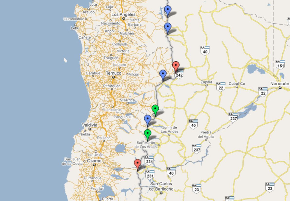
| Name | Route | Type | Notes |
|---|---|---|---|
| Paso Pichachén | Los Angeles - Zapala | Minor highway | |
| Paso Copahue | Los Angeles - Zapala | Minor highway | |
| Paso Pino Hachado | Temuco - Neuquén | Main highway | |
| Paso Icalma | Temuco - Neuquén | Minor highway | |
| Paso Mamuil Malal | Pucón - Junín de L.A. | Secondary highway | |
| Paso Carirriñe | Coñaripe - Junin de L.A. | Minor highway | |
| Paso Huahum | Panguipulli - S.M. de Los Andes | Secondary highway | |
| Paso Cardenal Antonio Samoré | Osorno - S.C. de Bariloche | Main highway |
Southern crossings
These are the passes of the barren, empty pampas of Southern Patagonia. There are no main roads around here, and in some cases there are barely any towns for the roads to connect to, either. I haven't personally travelled any of these crossings, nor have I visited this part of Chile or Argentina at all.
Some of these highways go through rivers, with satellite imagery showing no bridges connecting the two sides; I can only assume that the rivers are passable in 4WD, assuming the water levels are low, or assuming the rivers are partly frozen. This was also by far the most difficult region to research: information about these passes is scarce and undetailed.
Chilean regions: X (Los Lagos), XI (Aisén).
Argentine provinces: Chubut, Santa Cruz.
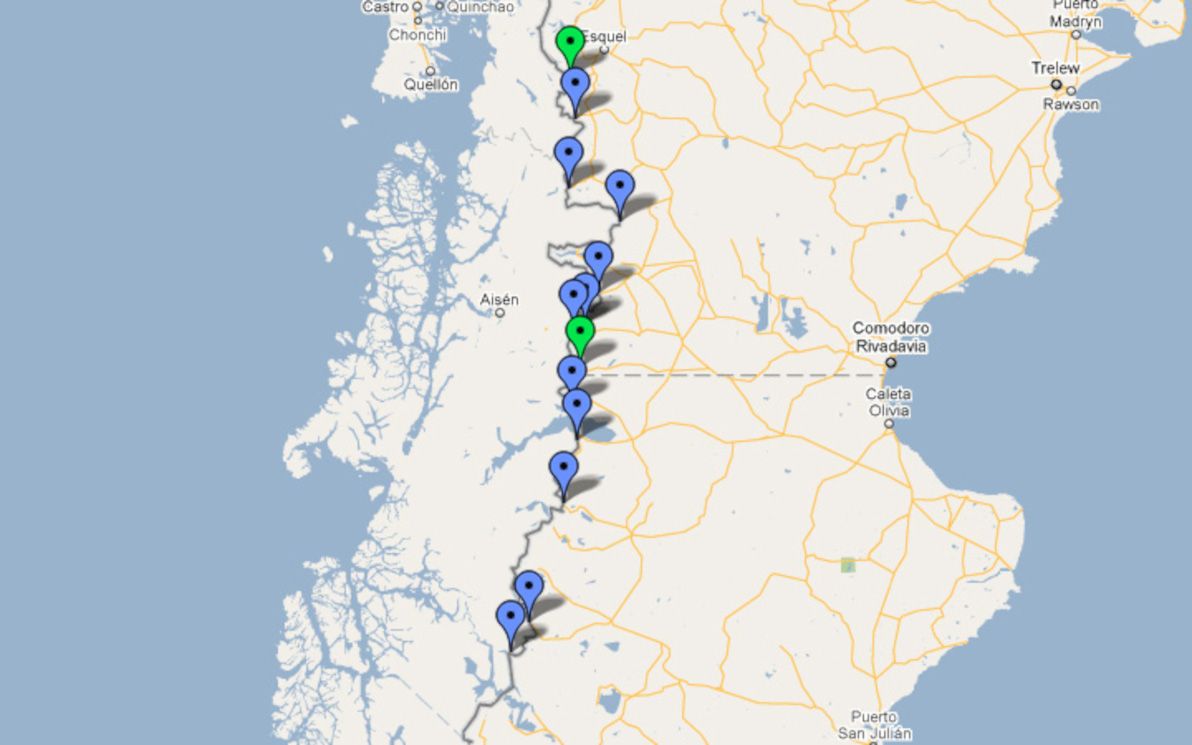
| Name | Route | Type |
|---|---|---|
| Paso Futaleufu | Futaleufu - Esquel | Secondary highway |
| Paso Río Encuentro | Palena - Esquel | Minor highway |
| Paso Las Pampas | Cisnes - Esquel | Minor highway |
| Paso Río Frias | Cisnes - Comodoro Rivadavia | Minor highway |
| Paso Pampa Alta | Coyhaique - Comodoro Rivadavia | Minor highway |
| Paso Coyhaique | Coyhaique - Comodoro Rivadavia | Minor highway |
| Paso Triana | Coyhaique - Comodoro Rivadavia | Minor highway |
| Paso Huemules | Coyhaique - Comodoro Rivadavia | Secondary highway |
| Paso Ingeniero Ibáñez-Pallavicini | Puerto Ibáñez - Perito Moreno | Minor highway |
| Paso Río Jeinemeni | Puerto Guadal - Perito Moreno | Minor highway |
| Paso Roballos | Cochrane - Bajo Caracoles | Minor highway |
| Paso Rio Mayer Ribera Norte | O'Higgins - Las Horquetas | Minor highway |
| Paso Rio Mosco | O'Higgins - Las Horquetas | Minor highway |
Extreme south crossings
The passes of the extreme south are easily crossed when weather conditions are good, as the mountains are much lower down here (or are basically plateaus). In winter, however, land transport is seldom an option. There is one main road in the extreme south, connecting Punta Arenas and Rio Gallegos.
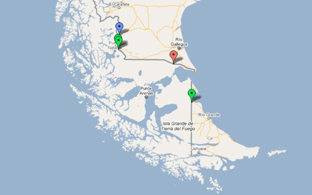
The only crossing I've made in the extreme south is through Paso Rio Don Guillermo, which is unsealed and is little more than a cattle track (although it's pretty straight and flat). The buses from Puerto Natales to El Calafate use this pass: the entrance to the road has a chain across it on both ends, which is unlocked by border police to let the buses through.
Chilean regions: XII (Magallanes).
Argentine provinces: Santa Cruz, Tierra del Fuego.
| Name | Route | Type | Notes |
|---|---|---|---|
| Paso Rio Don Guillermo | Puerto Natales - El Calafate | Minor highway | |
| Paso Dorotea | Puerto Natales - Rio Gallegos | Secondary highway | |
| Paso Laurita - Casas Vieja | Puerto Natales - Rio Gallegos | Secondary highway | |
| Paso Integración Austral | Punta Arenas - Río Gallegos | Main highway | |
| Paso San Sebastián | Porvenir - Rio Grande | Secondary highway |
Legend
Note: here's a link to the Google Map of Chile - Argentina border crossings that is referenced throughout this article.
Main highway
- Red markers on map
- Fully paved
- Public bus services
- Open almost year-round
- Customs and immigration integrated into the crossing
- Constant traffic
Secondary highway
- Green markers on map
- Partially paved
- Little or no public bus services
- Possibly closed some or most of the year
- Customs and immigration possibly integrated into the crossing
- Lesser or seasonal traffic
Minor highway
- Blue markers on map
- Unpaved
- No public bus services, and/or only open for authorised vehicles
- Not open year-round
- Customs and immigration must be done before and/or after the crossing
- Little or no traffic
Additional references
- Chilean government's list of permanent border crossings
- Wikipedia's list of all Argentine border crossings
- Wikipedia's list of countries and territories by land borders
- Viva travel guides: lakes district border crossings
- Neuquén tourism's border crossings list
- Look Patagonia's list of border crossings in Argentine Neuquén province
- Look Patagonia's list of border crossings in Argentine Chubut province
- Interpatagonia's list of passes that lead to Coyhaique