history - GreenAshPoignant wit and hippie ramblings that are pertinent to history
https://greenash.net.au/thoughts/topics/history/
2021-11-15T00:00:00ZThe lost Armidale to Wallangarra railway2021-11-15T00:00:00Z2021-11-15T00:00:00ZJazahttps://greenash.net.au/thoughts/2021/11/the-lost-armidale-to-wallangarra-railway/
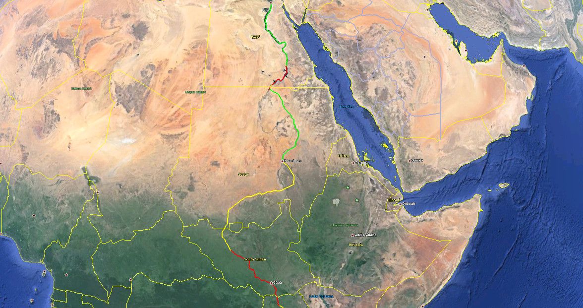
Running more-or-less alongside the most remote section of the New England Highway, through the Northern Tablelands region of NSW, can be found the remnants of a once-proud train line. The Great Northern Railway, as it was known in its heyday, provided the only railway service linking Sydney and Brisbane, between 1889 and 1930. Regular passenger services continued until 1972, and the line has been completely closed since 1988.
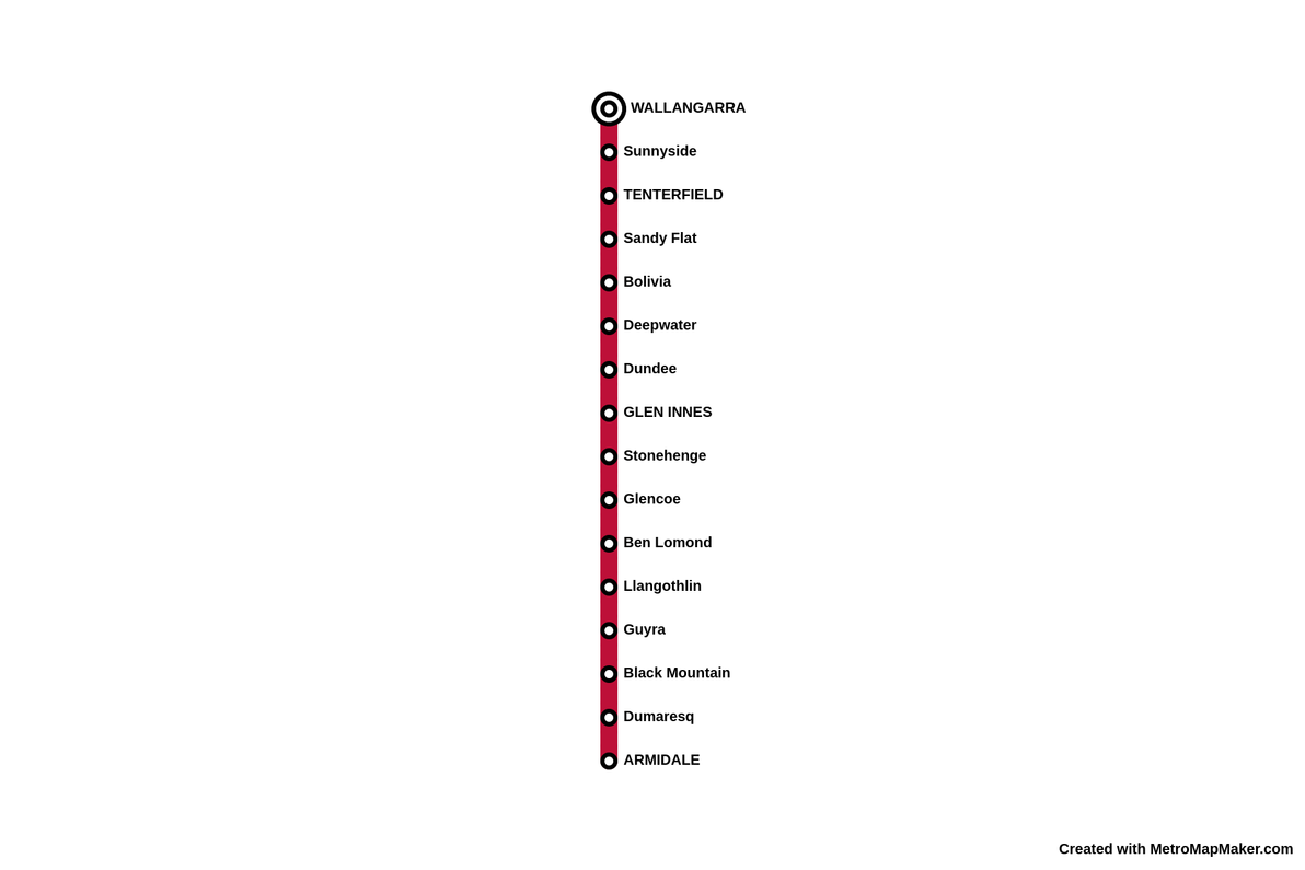
Metro map style illustration of the old Armidale to Wallangarra passenger service Thanks to:Metro Map Maker
Although I once drove through most of the Northern Tablelands, I wasn't aware of this railway, nor of its sad recent history, at the time. I just stumbled across it a few days ago, browsing maps online. I decided to pen this here wee thought, mainly because I was surprised at how scant information there is about the old line and its stations.
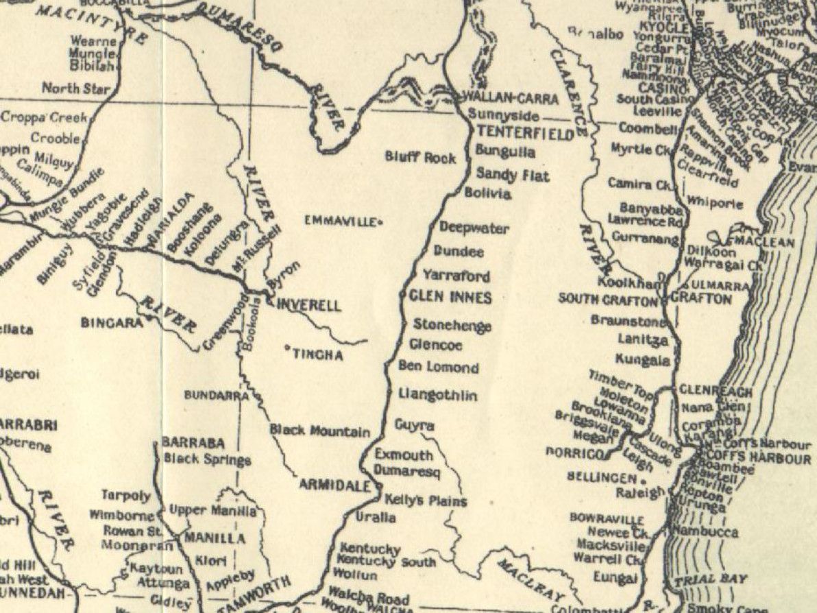
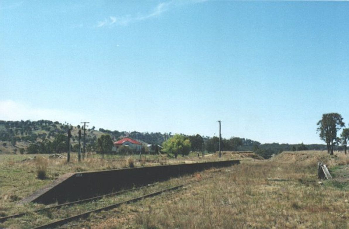
Great Northern Railway as shown in the 1933 official NSW government map Image source:NSWrail.net
You may notice that some of the stops shown in the 1933 map, are missing from my metro map style illustration. I have omitted all of the stops that are listed as something other than "station" in this long list of facilities on the Main North Line. As far as I can tell, all of the stops listed as "unknown" or "loop", were at best very frugal platform sidings that barely qualified as stations, and their locations were never really populated towns (even going by the generous Aussie bush definition of "populated town", that is, "two people, three pubs").
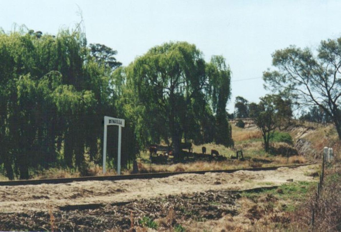
All that remains of Bungulla, just south of Tenterfield Image source:NSWrail.net
Although some people haven't forgotten about it – particularly many of the locals – the railway is clearly disappearing from the collective consciousness, just as it's slowly but surely eroding and rotting away out there in the New England countryside.
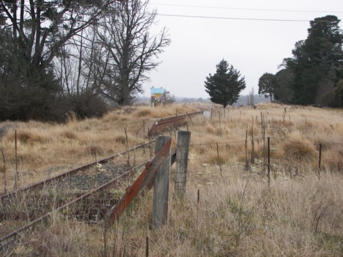
Stonehenge station, just south of Glen Innes, has seen better days Image source:NSWrail.net
Some of the stations along the old line were (apparently) once decent-sized towns, but it's not just the railway that's now long gone, it's the towns too! For example, Bolivia (the place that first caught my eye on the map, and that got me started researching all this – who would have imagined that there's a Bolivia in NSW?!), which legend has it was a bustling place at the turn of the 20th century, is nothing but a handful of derelict buildings now.
Bolivia ain't even a one-horse town no more Image source:NSWrail.net
Other stations – and other towns, for that matter – along the old railway, appear to be faring better. In particular, Black Mountain station is being most admirably maintained by a local group, and Black Mountain village is also alive and well.
The main platform at Black Mountain station Image source:NSWrail.net
These days, on the NSW side, the Main North Line remains open up to Armidale, and a passenger train service continues to operate daily between Sydney and Armidale. On the Queensland side, the Southern line between Toowoomba and Wallangarra is officially still open to this day, and is maintained by Queensland Rail, however my understanding is that there's only a train actually on the tracks, all the way down to Wallangarra, once in a blue moon. On the Main line, a passenger service currently operates twice a week between Brisbane and Toowoomba (it's the Westlander service, which continues from Toowoomba all the way to Charleville).
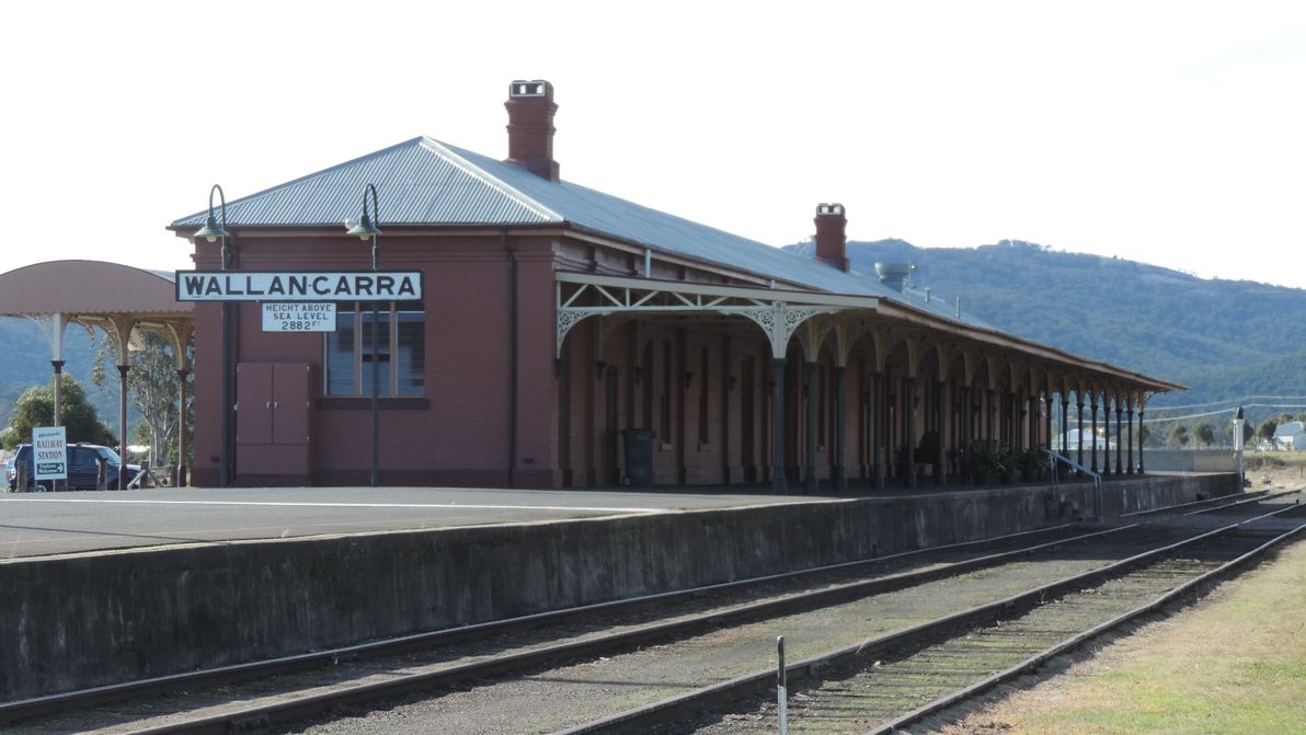
The unique Wallangarra station, with its standard-guage NSW side, and its narrow-guage Qld side Image source:Wikimedia Commons
The chances of the Armidale to Wallangarra railway ever re-opening are – to use the historically appropriate Aussie vernacular – Buckley's and none. The main idea that the local councils have been bandying about for the past few years, has been to convert the abandoned line into a rail trail for cycling. It looks like that plan is on the verge of going ahead, even though a number of local citizens are vehemently opposed to it. Personally, I don't think a rail trail is such a bad idea: the route will at least get more use, and will receive more maintenance, than it has for the past several decades; and it would bring a welcome trickle of tourists and adventurers to the region.
The Armidale to Wallangarra railway isn't completely lost nor forgotten. But it's a woeful echo of its long-gone glory days (it isn't even properly marked on Google Maps – although it's pretty well-marked on OpenStreetMap, and it's still quite visible on Google Maps satellite imagery). And, regretfully, it's one of countless many derelict train lines scattered across NSW: others include the Bombala line (which I've seen numerous times, running adjacent to the Monaro Highway, while driving down to Cooma from Sydney), the Nyngan to Bourke line, and the Murwillumbah line.
May this article, if nothing else, at least help to document what exactly the stations were on the old line, and how they're looking in this day and age. And, whether it's a rail trail or just an old relic by the time I get around to it, I'll have to head up there and see the old line for myself. I don't know exactly what future lies ahead for the Armidale to Wallangarra railway, but I sincerely hope that, both literally and figuratively, it doesn't simply fade into oblivion.
]]>
The eccentric tale of Gustave Eiffel and his Tower2018-10-16T00:00:00Z2018-10-16T00:00:00ZJazahttps://greenash.net.au/thoughts/2018/10/the-eccentric-tale-of-gustave-eiffel-and-his-tower/
The Eiffel Tower, as it turns out, is far more than just the most iconic tourist attraction in the world. As the tallest structure ever built by man at the time – and holder of the record "tallest man-made structure in the world" for 41 years, following its completion in 1889 – it was a revolutionary feat of structural engineering. It was also highly controversial – deeply unpopular, one might even say – with some of the most prominent Parisians of the day fiercely protesting against its "monstruous" form. And Gustave Eiffel, its creator, was brilliant, ambitious, eccentric, and thick-skinned.
From reading the wonderful epic novel Paris, by Edward Rutherford, I learned some facts about Gustave Eiffel's life, and about the Eiffel Tower's original conception, its construction, and its first few decades as the exclamation mark of the Paris skyline, that both surprised and intrigued me. Allow me to share these tidbits of history in this here humble article.
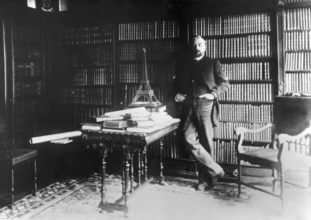
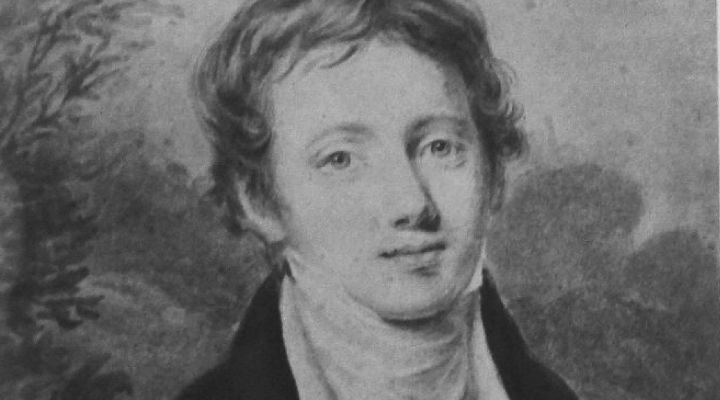
Gustave Eiffel hanging out with a model of his Tower. Image source:domain.com.au.
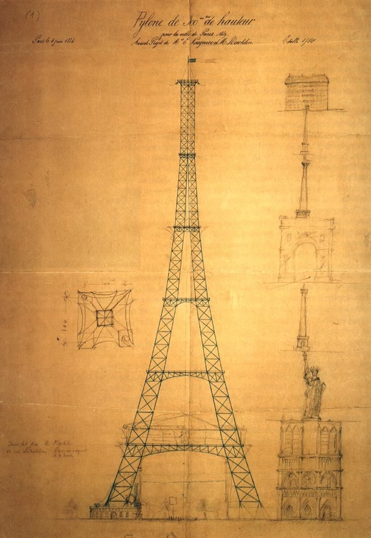
To begin with, the Eiffel Tower was not designed by Gustave Eiffel. The original idea and the first drafts of the design were produced by one Maurice Koechlin, who worked at Eiffel's firm. The same is true of Eiffel's other great claim to fame, the Statue of Liberty (which he built just before the Tower): after Eiffel's firm took over the project of building the statue, it was Koechlin who came up with Liberty's ingenious inner iron truss skeleton, and outer copper "skin", that makes her highly wind-resistant in the midst of blustery New York Harbour. It was a similar story for the Garabit Viaduct, and various other projects: although Eiffel himself was a highly capable engineer, it was Koechlin who was the mastermind, while Eiffel was the salesman and the celebrity.
Eiffel, and his colleagues Maurice Koechlin and Émile Nouguier, were engineers, not designers. In particular, they were renowned bridge-builders of their time. As such, their tower design was all about the practicalities of wind resistance, thermal expansion, and material strength; the Tower's aesthetic qualities were secondary considerations, with architect Stephen Sauvestre only being invited to contribute an artistic touch (such as the arches on the Tower's base), after the initial drafts were completed.
Koechlin's first draft of the Eiffel Tower. Image source:Wikimedia Commons.
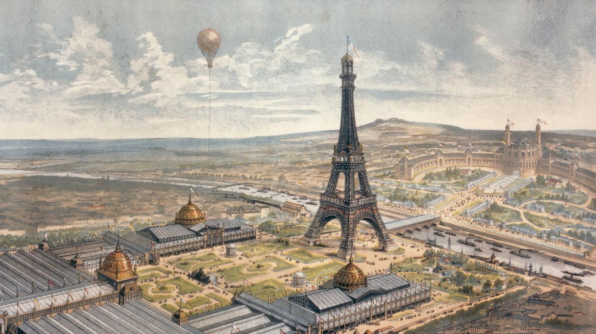
The Eiffel Tower was built as the centrepiece of the 1889 Exposition Universelle in Paris, after winning the 1886 competition that was held to find a suitable design. However, after choosing it, the City of Paris then put forward only a small modicum of the estimated money needed to build it, rather than the Tower's full estimated budget. As such, Eiffel agreed to cover the remainder of the construction costs out of his own pocket, but only on the condition that he receive all commercial income from the Tower, for 20 years from the date of its inauguration. This proved to be much to Eiffel's advantage in the long-term, as the Tower's income just during the Exposition Universelle itself – i.e. just during the first six months of its operating life – more than covered Eiffel's out-of-pocket costs; and the Tower has consistently operated at a profit ever since.
Illustration of the Eiffel Tower during the 1889 World's Fair. Image source:toureiffel.paris.
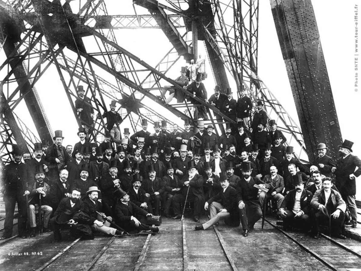
Pioneering construction projects of the 19th century (and, indeed, of all human history before then too) were, in general, hardly renowned for their occupational safety standards. I had always assumed that the building of the Eiffel Tower, which saw workmen reach more dizzying heights than ever before, had taken no small toll of lives. However, it just so happens that Gustave Eiffel was more than a mere engineer and a bourgeois, he was also a pioneer of safety: thanks to his insistence on the use of devices such as guard rails and movable stagings, the Eiffel Tower project amazingly saw only one fatality; and it wasn't even really a workplace accident, as the deceased, a workman named Angelo Scagliotti, climbed the tower while off duty, to impress his girlfriend, and sadly lost his footing.
The Tower's three levels, and its lifts and staircases, have always been accessible to the general public. However, something that not all visitors to the Tower may be aware of, is that near the summit of the Tower, just above the third level's viewing platform, sits what was originally Gustave Eiffel's private apartment. For the 20 years that he owned the rights to the Tower, Eiffel also enjoyed his own bachelor pad at the top! Eiffel reportedly received numerous requests to rent out the pad for a night, but he never did so, instead only inviting distinguished guests of his choosing, such as (no less than) Thomas Edison. The apartment is now open to the public as a museum. Still no word regarding when it will be listed on Airbnb; although another private apartment was more recently added lower down in the Tower and was rented out.
Eiffel's modest abode atop the world, as it looks today. Image source:The Independent.
So why did Eiffel's contract for the rights to the Tower stipulate 20 years? Because the plan was, that after gracing the Paris cityscape for that many years, it was to be torn down! That's right, the Eiffel Tower – which today seems like such an invincible monument – was only ever meant to be a temporary structure. And what saved it? Was it that the City Government came to realise what a tremendous cash cow it could inherit? Was it that Parisians came to love and to admire what they had considered to be a detestable blight upon their elegant city? Not at all! The only thing that saved the Eiffel Tower was that, a few years prior to its scheduled doomsday, a little thing known as radio had been invented. The French military, who had started using the Tower as a radio antenna – realising that it was the best antenna in all of Paris, if not the world at that time – promptly declared the Tower vital to the defence of Paris, thus staving off the wrecking ball.
The big crew gathered at the base of the Tower, Jul 1888. Image source:busy.org.
And the rest, as they say, is history. There are plenty more intriguing anecdotes about the Eiffel Tower, if you're interested in delving further. The Tower continued to have a colourful life, after the City of Paris relieved Eiffel of his rights to it in 1909, and after his death in 1923; and the story continues to this day. So, next time you have the good fortune of visiting La belle Paris, remember that there's much more to her tallest monument than just a fine view from the top.
]]>
How successful was the 20th century communism experiment?2017-11-28T00:00:00Z2017-11-28T00:00:00ZJazahttps://greenash.net.au/thoughts/2017/11/how-successful-was-the-20th-century-communism-experiment/
During the course of the 20th century, virtually every nation in the world was affected, either directly or indirectly, by the "red tide" of communism. Beginning with the Russian revolution in 1917, and ostensibly ending with the close of the Cold War in 1991 (but actually not having any clear end, because several communist regimes remain on the scene to this day), communism was and is the single biggest political and economic phenomenon of modern times.
Communism – or, to be more precise, Marxism – made sweeping promises of a rosy utopian world society: all people are equal; from each according to his ability, to each according to his need; the end of the bourgeoisie, the rise of the proletariat; and the end of poverty. In reality, the nature of the communist societies that emerged during the 20th century was far from this grandiose vision.
Communism obviously was not successful in terms of the most obvious measure: namely, its own longevity. The world's first and its longest-lived communist regime, the Soviet Union, well and truly collapsed. The world's most populous country, the People's Republic of China, is stronger than ever, but effectively remains communist in name only (as does its southern neighbour, Vietnam).
However, this article does not seek to measure communism's success based on the survival rate of particular governments; nor does it seek to analyse (in any great detail) why particular regimes failed (and there's no shortage of other articles that do analyse just that). More important than whether the regimes themselves prospered or met their demise, is their legacy and their long-term impact on the societies that they presided over. So, how successful was the communism experiment, in actually improving the economic, political, and cultural conditions of the populations that experienced it?
Communism: at least the party leaders had fun! Image source:FunnyJunk.
Success:
Health care in Cuba (internationally recognised as being one of the world's best and most accessible public health care systems)
The arts (Soviet theatre and Soviet ballet received funding and support for many years, as Cuban theatre still does; despite severely limiting artistic freedom, most communist regimes did actually make the arts thrive with subsidies)
Education (despite the heavy dose of propaganda in schools, almost all communist regimes have massively improved their populations' literacy rates, and have invested heavily in more schools and universities, and in universal access to them)
Industrialisation (putting aside for a moment the enormous sacrifices made to achieve it, the fact is that the USSR, China, and Vietnam transformed rapidly from agrarian economies into industrial powerhouses under communism, and they remain world industrial heavyweights today)
Freedom (all communist states so far in history have been totalitarian regimes, and have severely curtailed all freedoms – of speech, of movement, of artistic expression, of religion – and that oppressive legacy lives on to this day)
Corruption (far from the Marxist ideal of universal equality, it has most definitely been a case of some are more equal than others in communist states – communism has engendered endemic bribery and nepotism every time)
Human damage (rather than making everyone a winner, communism has generally made almost everyone a victim – as well as the huge number of people murdered, imprisoned, and tortured as enemies of a communist state, almost all citizens other than Party elites have endured prolonged suffering due to the states' constant intrusion into their lives)
Dudes, don't leave a comrade hanging. Image source:FunnyJunk.
Closing remarks
Personally, I have always considered myself quite a "leftie": I'm a supporter of socially progressive causes, and in particular, I've always been involved with environmental movements. However, I've never considered myself a socialist or a communist, and I hope that this brief article on communism reflects what I believe are my fairly balanced and objective views on the topic.
Based on my list of pros and cons above, I would quite strongly tend to conclude that, overall, the communism experiment of the 20th century was not successful at improving the economic, political, and cultural conditions of the populations that experienced it.
I'm reluctant to draw comparisons, because I feel that it's a case of apples and oranges, and also because I feel that a pure analysis should judge communist regimes on their merits and faults, and on theirs alone. However, the fact is that, based on the items in my lists above, much more success has been achieved, and much less failure has occurred, in capitalist democracies, than has been the case in communist states (and the pinnacle has really been achieved in the world's socialist democracies). The Nordic Model – and indeed the model of my own home country, Australia – demonstrates that a high quality of life and a high level of equality are attainable without going down the path of Marxist Communism; indeed, arguably those things are attainable only if Marxist Communism is avoided.
I hope you appreciate what I have endeavoured to do in this article: that is, to avoid the question of whether or not communist theory is fundamentally flawed; to avoid a religious rant about the "evils" of communism or of capitalism; and to avoid judging communism based on its means, and to instead concentrate on what ends it achieved. And I humbly hope that I have stuck to that plan laudably. Because if one thing is needed more than anything else in the arena of analyses of communism, it's clear-sightedness, and a focus on the hard facts, rather than religious zeal and ideological ranting.
]]>
Orientalists of the East India Company2016-10-18T00:00:00Z2016-10-18T00:00:00ZJazahttps://greenash.net.au/thoughts/2016/10/orientalists-of-the-east-india-company/
The infamous East India Company, "the Company that Owned a Nation", is remembered harshly by history. And rightly so. On the whole, it was an exploitative venture, and the British individuals involved with it were ruthless opportunists. The Company's actions directly resulted in the impoverishment, the subjugation, and in several instances the death of countless citizens of the Indian Subcontinent.
Company rule, and the subsequent rule of the British Raj, are also acknowledged as contributing positively to the shaping of Modern India, having introduced the English language, built the railways, and established political and military unity. But these are overshadowed by its legacy of corporate greed and wholesale plunder, which continues to haunt the region to this day.
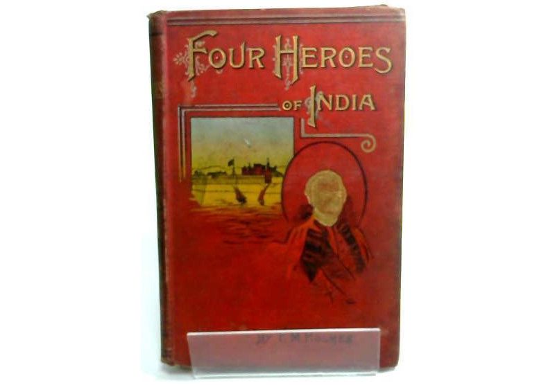
I recently read Four Heroes of India (1898), by F.M. Holmes, an antique book that paints a rose-coloured picture of Company (and later British Government) rule on the Subcontinent. To the modern reader, the book is so incredibly biased in favour of British colonialism that it would be hilarious, were it not so alarming. Holmes's four heroes were notable military and government figures of 18th and 19th century British India.
Clive, Hastings, Havelock, Lawrence; with a Concluding Note on the Rule of Lord Mayo. Image source:eBay.
I'd like to present here four alternative heroes: men (yes, sorry, still all men!) who in my opinion represented the British far more nobly, and who left a far more worthwhile legacy in India. All four of these figures were founders or early members of The Asiatic Society (of Bengal), and all were pioneering academics who contributed to linguistics, science, and literature in the context of South Asian studies.
William Jones
The first of these four personalities was by far the most famous and influential. Sir William Jones was truly a giant of his era. The man was nothing short of a prodigy in the field of philology (which is arguably the pre-modern equivalent of linguistics). During his productive life, Jones is believed to have become proficient in no less than 28 languages, making him quite the polyglot:
Eight languages studied critically: English, Latin, French, Italian, Greek, Arabic, Persian, Sanscrit [sic]. Eight studied less perfectly, but all intelligible with a dictionary: Spanish, Portuguese, German, Runick [sic], Hebrew, Bengali, Hindi, Turkish. Twelve studied least perfectly, but all attainable: Tibetian [sic], Pâli [sic], Pahlavi, Deri …, Russian, Syriac, Ethiopic, Coptic, Welsh, Swedish, Dutch, Chinese. Twenty-eight languages.
Jones is most famous in scholarly history for being the person who first proposed the linguistic family of Indo-European languages, and thus for being one of the fathers of comparative linguistics. His work laid the foundations for the theory of a Proto-Indo-European mother tongue, which was researched in-depth by later linguists, and which is widely accepted to this day as being a language that existed and that had a sizeable native speaker population (despite there being no concrete evidence for it).
Jones spent 10 years in India, working in Calcutta as a judge. During this time, he founded The Asiatic Society of Bengal. Jones was the foremost of a loosely-connected group of British gentlemen who called themselves orientalists. (At that time, "oriental studies" referred primarily to India and Persia, rather than to China and her neighbours as it does today.)
Like his peers in the Society, Jones was a prolific translator. He produced the authoritative English translation of numerous important Sanskrit documents, including Manu Smriti (Laws of Manu), and Abhiknana Shakuntala. In the field of his "day job" (law), he established the right of Indian citizens to trial by jury under Indian jurisprudence. Plus, in his spare time, he studied Hindu astronomy, botany, and literature.
James Prinsep
The numismatist James Prinsep, who worked at the Benares (Varanasi) and Calcutta mints in India for nearly 20 years, was another of the notable British orientalists of the Company era. Although not quite in Jones's league, he was nevertheless an intelligent man who made valuable contributions to academia. His life was also unfortunately short: he died at the age of 40, after falling sick of an unknown illness and failing to recover.
Prinsep was the founding editor of the Journal of the Asiatic Society of Bengal. He is best remembered as the pioneer of numismatics (the study of coins) on the Indian Subcontinent: in particular, he studied numerous coins of ancient Bactrian and Kushan origin. Prinsep also worked on deciphering the Kharosthi and Brahmi scripts; and he contributed to the science of meteorology.
Charles Wilkins
The typographer Sir Charles Wilkins arrived in India in 1770, several years before Jones and most of the other orientalists. He is considered the first British person in Company India to have mastered the Sanskrit language. Wilkins is best remembered as having created the world's first Bengali typeface, which became a necessity when he was charged with printing the important text A Grammar of the Bengal Language (the first book written in Bengali to ever be printed), written by fellow orientalist Nathaniel Brassey Halhed, and more-or-less commissioned by Governor Warren Hastings.
It should come as no surprise that this pioneering man was one of the founders of The Asiatic Society of Bengal. Like many of his colleagues, Wilkins left a proud legacy as a translator: he was the first person to translate into English the Bhagavad Gita, the most revered holy text in all of Hindu lore. He was also the first director of the "India Office Library".
H. H. Wilson
The doctor Horace Hayman Wilson was in India slightly later than the other gentlemen listed here, not having arrived in India (as a surgeon) until 1808. Wilson was, for a part of his time in Company India, honoured with the role of Secretary of the Asiatic Society of Bengal.
Wilson was one of the key people to continue Jones's great endeavour of bridging the gap between English and Sanskrit. His key contribution was writing the world's first comprehensive Sanskrit-English dictionary. He also translated the Meghaduuta into English. In his capacity as a doctor, he researched and published on the matter of traditional Indian medical practices. He also advocated for the continued use of local languages (rather than of English) for instruction in Indian native schools.
The legacy
There you have it: my humble short-list of four men who represent the better side of the British presence in Company India. These men, and other orientalists like them, are by no means perfect, either. They too participated in the Company's exploitative regime. They too were part of the ruling elite. They were no Mother Teresa (the main thing they shared in common with her was geographical location). They did little to help the day-to-day lives of ordinary Indians living in poverty.
Nevertheless, they spent their time in India focused on what I believe were noble endeavours; at least, far nobler than the purely military and economic pursuits of many of their peers. Their official vocations were in administration and business enterprise, but they chose to devote themselves as much as possible to academia. Their contributions to the field of language, in particular – under that title I include philology, literature, and translation – were of long-lasting value not just to European gentlemen, but also to the educational foundations of modern India.
In recent times, the term orientalism has come to be synonymous with imperialism and racism (particularly in the context of the Middle East, not so much for South Asia). And it is argued that the orientalists of British India were primarily concerned with strengthening Company rule by extracting knowledge, rather than with truly embracing or respecting India's cultural richness. I would argue that, for the orientalists presented here at least, this was not the case: of course they were agents of British interests, but they also genuinely came to respect and admire what they studied in India, rather than being contemptuous of it.
The legacy of British orientalism in India was, in my opinion, one of the better legacies of British India in general. It's widely acknowledged that it had a positive long-term educational and intellectual effect on the Subcontinent. It's also a topic about which there seems to be insufficient material available – particularly regarding the biographical details of individual orientalists, apart from Jones – so I hope this article is useful to anyone seeking further sources.
]]>
Robert Dawson: the first anthropologist of Aborigines?2015-09-26T00:00:00Z2015-09-26T00:00:00ZJazahttps://greenash.net.au/thoughts/2015/09/robert-dawson-the-first-anthropologist-of-aborigines/
The treatment of Aboriginal Australians in colonial times was generally atrocious. This is now well known and accepted by most. Until well into the 20th century, Aborigines were subjected to exploitation, abuse, and cold-blooded murder. They were regarded as sub-human, and they were not recognised at all as the traditional owners of their lands. For a long time, virtually no serious attempts were made to study or to understand their customs, their beliefs, and their languages. On the contrary, the focus was on "civilising" them by imposing upon them a European way of life, while their own lifestyle was held in contempt as "savage".
I recently came across a gem of literary work, from the early days of New South Wales: The Present State of Australia, by Robert Dawson. The author spent several years (1826-1828) living in the Port Stephens area (about 200km north of Sydney), as chief agent of the Australian Agricultural Company, where he was tasked with establishing a grazing property. During his time there, Dawson lived side-by-side with the Worimi indigenous peoples, and Worimi anecdotes form a significant part of his book (which, officially, is focused on practical advice for British people considering migration to the Australian frontier).
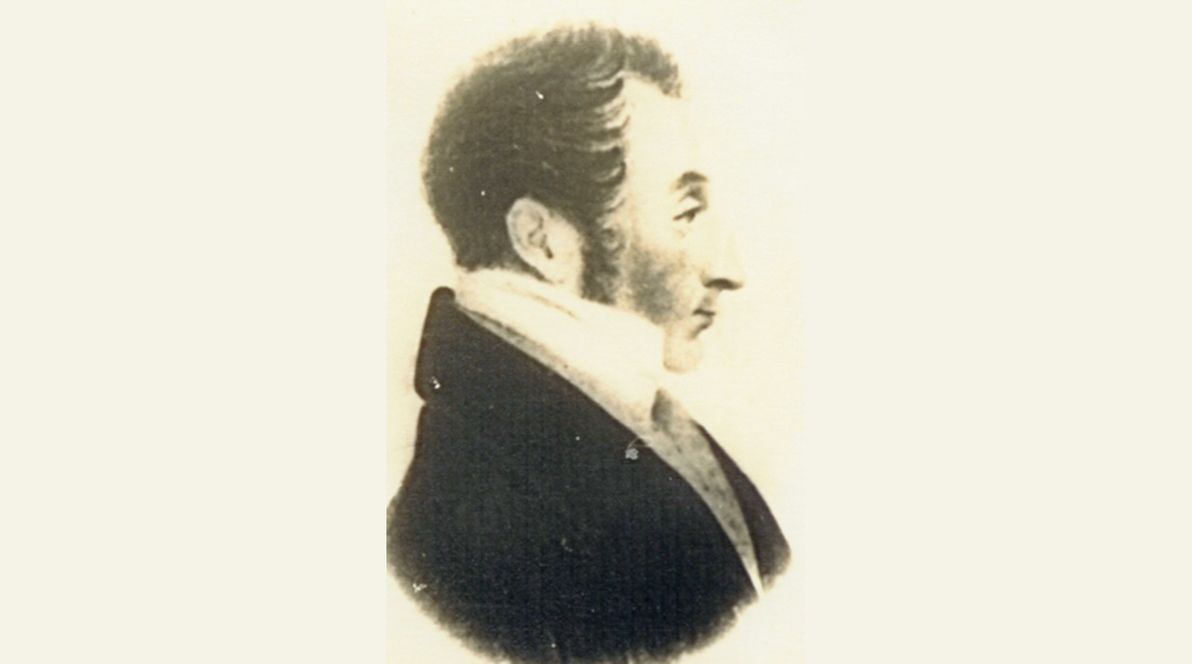
Robert Dawson of the Australian Agricultural Company. Image source:Wikimedia Commons.
In this article, I'd like to share quite a number of quotes from Dawson's book, which in my opinion may well constitute the oldest known (albeit informal) anthropological study of Indigenous Australians. Considering his rich account of Aboriginal tribal life, I find it surprising that Dawson seems to have been largely forgotten by the history books, and that The Present State of Australia has never been re-published since its first edition in 1830 (the copies produced in 1987 are just fascimiles of the original). I hope that this article serves as a tribute to someone who was an exemplary exception to what was then the norm.
Language
The book includes many passages containing Aboriginal words interspersed with English, as well as English words spelt phonetically (and amusingly) as the tribespeople pronounced them; contemporary Australians should find many of these examples familiar, from the modern-day Aboriginal accents:
Before I left Port Stephens, I intimated to them that I should soon return in a "corbon" (large) ship, with a "murry" (great) plenty of white people, and murry tousand things for them to eat … They promised to get me "murry tousand bark." "Oh! plenty bark, massa." "Plenty black pellow, massa: get plenty bark." "Tree, pour, pive nangry" (three, four, five days) make plenty bark for white pellow, massa." "You come back toon?" "We look out for corbon ship on corbon water," (the sea.) "We tee, (see,) massa." … they sent to inform me that they wished to have a corrobery (dance) if I would allow it.
(page 60)
On occasion, Dawson even goes into grammatical details of the indigenous languages:
"Bael me (I don't) care." The word bael means no, not, or any negative: they frequently say, "Bael we like it;" "Bael dat good;" "Bael me go dere."
(page 65)
It's clear that Dawson himself became quite prolific in the Worimi language, and that – at least for a while – an English-Worimi "creole" emerged as part of white-black dialogue in the Port Stephens area.
Food and water
Although this is probably one of the better-documented Aboriginal traits from the period, I'd also like to note Dawson's accounts of the tribespeoples' fondness for European food, especially for sugar:
They are exceedingly fond of biscuit, bread, or flour, which they knead and bake in the ashes … but the article of food which appears most delicious to them, is the boiled meal of Indian corn; and next to it the corn roasted in the ashes, like chestnuts: of sugar too they are inordinately fond, as well as of everything sweet. One of their greatest treats is to get an Indian bag that has had sugar in it: this they cut into pieces and boil in water. They drink this liquor till they sometimes become intoxicated, and till they are fairly blown out, like an ox in clover, and can take no more.
(page 59)
Dawson also described their manner of eating; his account is not exactly flattering, and he clearly considers this behaviour to be "savage":
The natives always eat (when allowed to do so) till they can go on no longer: they then usually fall asleep on the spot, leaving the remainder of the kangaroo before the fire, to keep it warm. Whenever they awake, which is generally three or four times during the night, they begin eating again; and as long as any food remains they will never stir from the place, unless forced to do so. I was obliged at last to put a stop, when I could, to this sort of gluttony, finding that it incapacitated them from exerting themselves as they were required to do the following day.
(page 123)
Regarding water, Dawson gave a practical description of the Worimi technique for getting a drink in the bush in dry times (and admits that said technique saved him from being up the creek a few times); now, of course, we know that similar techniques were common for virtually all Aboriginal peoples across Australia:
It sometimes happens, in dry seasons, that water is very scarce, particularly near the shores. In such cases, whenever they find a spring, they scratch a hole with their fingers, (the ground being always sandy near the sea,) and suck the water out of the pool through tufts or whisps of grass, in order to avoid dirt or insects. Often have I witnessed and joined in this, and as often felt indebted to them for their example.
They would walk miles rather than drink bad water. Indeed, they were such excellent judges of water, that I always depended upon their selection when we encamped at a distance from a river, and was never disappointed.
(page 150)
Tools and weapons
In numerous sections, Dawson described various tools that the Aborigines used, and their skill and dexterity in fashioning and maintaining them:
[The old man] scraped the point of his spear, which was at least about eight feet long, with a broken shell, and put it in the fire to harden. Having done this, he drew the spear over the blaze of the fire repeatedly, and then placed it between his teeth, in which position he applied both his hands to straighten it, examining it afterwards with one eye closed, as a carpenter would do his planed work. The dexterous and workmanlike manner in which he performed his task, interested me exceedingly; while the savage appearance and attitude of his body, as he sat on the ground before a blazing fire in the forest, with a black youth seated on either side of him, watching attentively his proceedings, formed as fine a picture of savage life as can be conceived.
(page 16)
To the modern reader such as myself, Dawson's use of language (e.g. "a picture of savage life") invariably gives off a whiff of contempt and "European superiority". Personally, I try to give him the benefit of the doubt, and to brush this off as simply "using the vernacular of the time". In my opinion, this is fair justification for Dawson's manner of writing to some extent; but it also shows that he wasn't completely innocent, either: he too held some of the very views which he criticised in his contemporaries.
The tribespeople also exercised great agility in gathering the raw materials for their tools and shelters:
Before a white man can strip the bark beyond his own height, he is obliged to cut down the tree; but a native can go up the smooth branchless stems of the tallest trees, to any height, by cutting notches in the surface large enough only to place the great toe in, upon which he supports himself, while he strips the bark quite round the tree, in lengths from three to six feet. These form temporary sides and coverings for huts of the best description.
(page 19)
And they were quite dexterous in their crafting of nets and other items:
They [the women] make string out of bark with astonishing facility, and as good as you can get in England, by twisting and rolling it in a curious manner with the palm of the hand on the thigh. With this they make nets … These nets are slung by a string round their forehead, and hang down their backs, and are used like a work-bag or reticule. They contain all the articles they carry about with them, such as fishing hooks made from oyster or pearl shells, broken shells, or pieces of glass, when they can get them, to scrape the spears to a thin and sharp point, with prepared bark for string, gum for gluing different parts of their war and fishing spears, and sometime oysters and fish when they move from the shore to the interior.
(page 67)
Music and dance
Dawson wrote fondly of his being witness to corroborees on several occasions, and he recorded valuable details of the song and dance involved:
A man with a woman or two act as musicians, by striking two sticks together, and singing or bawling a song, which I cannot well describe to you; it is chiefly in half tones, extending sometimes very high and loud, and then descending so low as almost to sink to nothing. The dance is exceedingly amusing, but the movement of the limbs is such as no European could perform: it is more like the limbs of a pasteboard harlequin, when set in motion by a string, than any thing else I can think of. They sometimes changes places from apparently indiscriminate positions, and then fall off in pairs; and after this return, with increasing ardour, in a phalanx of four and five deep, keeping up the harlequin-like motion altogether in the best time possible, and making a noise with their lips like "proo, proo, proo;" which changes successively to grunting, like the kangaroo, of which it is an imitation, and not much unlike that of a pig.
(page 61)
Note Dawson's poetic efforts to bring to life the corroboree in words, with "bawling" sounds, "phalanx" movements, and "harlequin-like motion". Modern-day writers probably wouldn't bother to go to such lengths, instead assuming that their audience is familiar with the sights and sounds in question (at the very least, from TV shows). Dawson, who was writing for a Victorian English audience, didn't enjoy this luxury.
Families
In an era when most "white fellas" in the Colony were irrevocably destroying traditional Aboriginal family ties (a practice that was to continue well into the 20th century), Dawson was appreciating and making note of the finer details that he witnessed:
They are remarkably fond of their children, and when the parents die, the children are adopted by the unmarried men and women, and taken the greatest care of.
(page 68)
He also observed the prevalence of monogamy amongst the tribes he encountered:
The husband and wife are in general remarkably constant to each other, and it rarely happens that they separate after having considered themselves as man and wife; and when an elopement or the stealing of another man's gin [wife] takes place, it creates great, and apparently lasting uneasiness in the husband.
(page 154)
As well as the enduring bonds between parents and children:
The parents retain, as long as they live, an influence over their children, whether married or not – I then asked him the reason of this [separating from his partner], and he informed me his mother did not like her, and that she wanted him to choose a better.
(page 315)
Dawson made note of the good and the bad; in the case of families, he condoned the prevalence of domestic violence towards women in the Aboriginal tribes:
On our first coming here, several instances occurred in our sight of the use of this waddy [club] upon their wives … When the woman sees the blow coming, she sometimes holds her head quietly to receive it, much like Punch and his wife in the puppet-shows; but she screams violently, and cries much, after it has been inflicted. I have seen but few gins [wives] here whose heads do not bear the marks of the most dreadful violence of this kind.
(page 66)
Clothing
Some comical accounts of how the Aborigines took to the idea of clothing in the early days:
They are excessively fond of any part of the dress of white people. Sometimes I see them with an old hat on: sometimes with a pair of old shoes, or only one: frequently with an old jacket and hat, without trowsers: or, in short, with any garment, or piece of a garment, that they can get.
(page 75)
They usually reacted well to gifts of garments:
On the following morning I went on board the schooner, and ordered on shore a tomahawk and a suit of slop clothes, which I had promised to my friend Ben, and in which he was immediately dressed. They consisted of a short blue jacket, a checked shirt, and a pair of dark trowsers. He strutted about in them with an air of good-natured importance, declaring that all the harbour and country adjoining belonged to him. "I tumble down [born] pickaninny [child] here," he said, meaning that he was born there. "Belonging to me all about, massa; pose you tit down here, I gib it to you." "Very well," I said: "I shall sit down here." "Budgeree," (very good,) he replied, "I gib it to you;" and we shook hands in ratification of the friendly treaty.
(page 12)
Death and religion
Yet another topic which was scarcely investigated by Dawson's colonial peers – and which we now know to have been of paramount importance in all Aborigines' belief systems — rituals regarding death and mourning:
… when any of their relations die, they show respect for their memories by plastering their heads and faces all over with pipe-clay, which remains till it falls off of itself. The gins [wives] also burn the front of the thigh severely, and bind the wound up with thin strips of bark. This is putting themselves in mourning. We put on black; they put on white: so that it is black and white in both cases.
(page 74)
The Aborigines that Dawson became acquainted with, were convinced that the European settlers were re-incarnations of their ancestors; this belief was later found to be fairly widespread amongst Australia's indigenous peoples:
I cannot learn, precisely, whether they worship any God or not; but they are firm in their belief that their dead friends go to another country; and that they are turned into white men, and return here again.
(page 74)
Dawson appears to have debated this topic at length with the tribespeople:
"When he [the devil] makes black fellow die," I said, "what becomes of him afterwards?" "Go away Englat," (England,) he answered, "den come back white pellow." This idea is so strongly impressed upon their minds, that when they discover any likeness between a white man and any one of their deceased friends, they exclaim immediately, "Dat black pellow good while ago jump up white pellow, den come back again."
(page 158)
Inter-tribe relations
During his time with the Worimi and other tribes, Dawson observed many of the details of how neighbouring tribes interacted, for example, in the case of inter-tribal marriage:
The blacks generally take their wives from other tribes, and if they can find opportunities they steal them, the consent of the female never being made a question in the business. When the neighbouring tribes happen to be in a state of peace with each other, friendly visits are exchanged, at which times the unmarried females are carried off by either party.
(page 153)
In one chapter, Dawson gives an amusing account of how the Worimi slandered and villainised another tribe (the Myall people), with whom they were on unfriendly terms:
The natives who domesticate themselves amongst the white inhabitants, are aware that we hold cannibalism in abhorrence; and in speaking of their enemies, therefore, to us, they always accuse them of this revolting practice, in order, no doubt, to degrade them as much as possible in our eyes; while the other side, in return, throw back the accusation upon them. I have questioned the natives who were so much with me, in the closest manner upon this subject, and although they persist in its being the practice of their enemies, still they never could name any particular instances within their own knowledge, but always ended by saying: "All black pellow been say so, massa." When I have replied, that Myall black fellows accuse them of it also, the answer has been, "Nebber! nebber black pellow belonging to Port Tebens, (Stephens;) murry [very] corbon [big] lie, massa! Myall black pellows patter (eat) always."
(page 125)
The book also explains that the members of a given tribe generally kept within their own ancestral lands, and that they were reluctant and fearful of too-often making contact with neighbouring tribes:
… the two natives who had accompanied them had become frightened at the idea of meeting strange natives, and had run away from them about the middle of their journey …
(page 24)
Relations with colonists
Throughout the book, general comments are made that insinuate the fault and the aggression in general of "white fella" in the Colony:
The natives are a mild and harmless race of savages; and where any mischief has been done by them, the cause has generally arisen, I believe, in bad treatment by their white neighbours. Short as my residence has been here, I have, perhaps, had more intercourse with these people, and more favourable opportunities of seeing what they really are, than any other person in the colony.
(page 57)
Dawson provides a number of specific examples of white aggression towards the Aborigines:
The natives complained to me frequently, that "white pellow" (white fellows) shot their relations and friends; and showed me many orphans, whose parents had fallen by the hands of white men, near this spot. They pointed out one white man, on his coming to beg some provisions for his party up the river Karuah, who, they said, had killed ten; and the wretch did not deny it, but said he would kill them whenever he could.
(page 58)
Sydney
As a modern-day Sydneysider myself, I had a good chuckle reading Dawson's account of his arrival for the first time in Sydney, in 1826:
There had been no arrival at Sydney before us for three or four months. The inhabitants were, therefore, anxious for news. Parties of ladies and gentlemen were parading on the sides of the hills above us, greeting us every now and then, as we floated on; and as soon as we anchored, (which was on a Sunday,) we were boarded by numbers of apparently respectable people, asking for letters and news, as if we had contained the budget of the whole world.
(page 46)
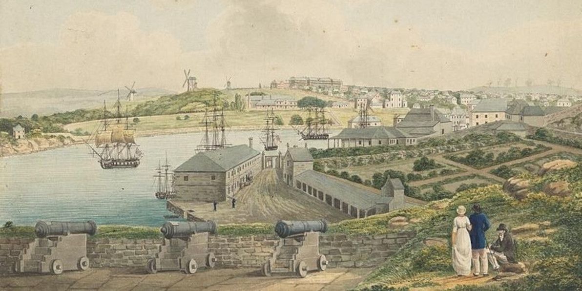
View of Sydney Cove from Dawes Point by Joseph Lycett, ca 1817-1818. Image source:Wikipedia.
No arrival in Sydney, from the outside world, for "three or four months"?! Who would have thought that a backwater penal town such as this, would one day become a cosmopolitan world city, that sees a jumbo jet land and take off every 5 minutes, every day of the week? Although, it seems that even back then, Dawson foresaw something of Sydney's future:
On every side of the town [Sydney] houses are being erected on new ground; steam engines and distilleries are at work; so that in a short time a city will rise up in this new world equal to any thing out of Europe, and probably superior to any other which was ever created in the same space of time.
(page 47)
And, even back then, there were some (like Dawson) who preferred to get out of the "rat race" of Sydney town:
Since my arrival I have spent a good deal of time in the woods, or bush, as it is called here. For the last five months I have not entered or even seen a house of any kind. My habitation, when at home, has been a tent; and of course it is no better when in the bush.
(page 48)
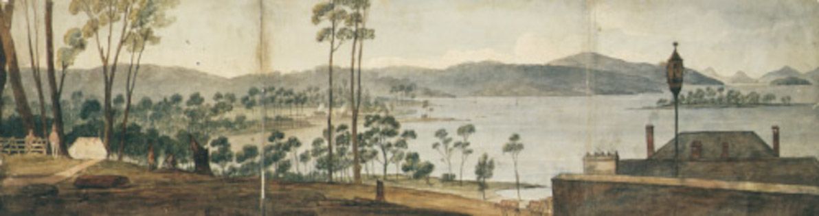
Stockton Beach, just below Port Stephens, was several years ago declared Worimi land. Image source:NSW National Parks.
There's still a fair bit of bush all around Sydney; although, sadly, not as much as there was in Dawson's day.
General remarks
Dawson's impression of the Aborigines:
I was much amused at this meeting, and above all delighted at the prompt and generous manner in which this wild and untutored man conducted himself towards his wandering brother. If they be savages, thought I, they are very civil ones; and with kind treatment we have not only nothing to fear, but a good deal to gain from them. I felt an ardent desire to cultivate their acquaintance, and also much satisfaction from the idea that my situation would afford me ample opportunities and means for doing so.
(page 11)
Nomadic nature of the tribes:
When away from this settlement, they appear to have no fixed place of residence, although they have a district of country which they call theirs, and in some part of which they are always to be found. They have not, as far as I can learn, any king or chief.
(page 63)
Tribal punishment:
I have never heard but of one punishment, which is, I believe, inflicted for all offences. It consists in the culprit standing, for a certain time, to defend himself against the spears which any of the assembled multitude think proper to hurl at him. He has a small target [shield] … and the offender protects himself so dexterously by it, as seldom to receive any injury, although instances have occurred of persons being killed.
(page 64)
Generosity of Aborigines (also illustrating their lack of a concept of ownership / personal property):
They are exceedingly kind and generous towards each other: if I give tobacco or any thing else to any man, it is divided with the first he meets without being asked for it.
(page 68)
Ability to count / reckon:
They have no idea of numbers beyond five, which are reckoned by the fingers. When they wish to express a number, they hold up so many fingers: beyond five they say, "murry tousand," (many thousands.)
(page 75)
Protocol for returning travellers in a tribe:
It is not customary with the natives of Australia to shake hands, or to greet each other in any way when they meet. The person who has been absent and returns to his friends, approaches them with a serious countenance. The party who receives him is the first to speak, and the first questions generally are, where have you been? Where did you sleep last night? How many days have you been travelling? What news have you brought? If a member of the tribe has been very long absent, and returns to his family, he stops when he comes within about ten yards of the fire, and then sits down. A present of food, or a pipe of tobacco is sent to him from the nearest relation. This is given and received without any words passing between them, whilst silence prevails amongst the whole family, who appear to receive the returned relative with as much awe as if he had been dead, and it was his spirit which had returned to them. He remains in this position perhaps for half an hour, till he receives a summons to join his family at the fire, and then the above questions are put to him.
(page 132)
Final thoughts
The following pages are not put forth to gratify the vanity of authorship, but with the view of communicating facts where much misrepresentation has existed, and to rescue, as far as I am able, the character of a race of beings (of whom I believe I have seen more than any other European has done) from the gross misrepresentations and unmerited obloquy that has been cast upon them.
(page xiii)
Dawson wasn't exactly modest, in his assertion of being the foremost person in the Colony to make a fair representation of the Aborigines; however, I'd say his assertion is quite accurate. As far as I know, he does stand out as quite a solitary figure for his time, in his efforts to meaningfully engage with the tribes of the greater Sydney region, and to document them in a thorough and (relatively) unprejudiced work of prose.
I would therefore recommend those who would place the Australian natives on the level of brutes, to reflect well on the nature of man in his untutored state in comparison with his more civilized brother, indulging in endless whims and inconsistencies, before they venture to pass a sentence which a little calm consideration may convince them to be unjust.
(page 152)
Dawson's criticism of the prevailing attitudes was scathing, although it was clearly criticism that was ignored and unheeded by his contemporaries.
It is not sufficient merely as a passing traveller to see an aboriginal people in their woods and forests, to form a just estimate of their real character and capabilities … To know them well it is necessary to see much more of them in their native wilds … In this position I believe no man has ever yet been placed, although that in which I stood approached more nearly to it than any other known in that country.
(page 329)
With statements like this, Dawson is inviting his fellow colonists to "go bush" and to become acquainted with an Aboriginal tribe, as he did. From others' accounts of the era, those who followed in his footsteps were few and far between.
I have seen the natives from the coast far south of Sydney, and thence to Morton Bay (sic), comprising a line of coast six or seven hundred miles; and I have also seen them in the interior of Argyleshire and Bathurst, as well as in the districts of the Hawkesbury, Hunter's River, and Port Stephens, and have no reason whatever to doubt that they are all the same people.
(page 336)
So, why has a man and a book with so much to say about early contact with the Aborigines, lain largely forgotten and abandoned by the fickle sands of history? Probably the biggest reason, is that Dawson was just a common man. Sure, he was the first agent of AACo: but he was no intrepid explorer, like Burke and Wills; nor an important governor, like Arthur Phillip or Lachlan Macquarie. While the diaries and letters of bigwigs like these have been studied and re-published constantly, not everyone can enjoy the historical limelight.
No doubt also a key factor, was that Dawson ultimately fell out badly with the powerful Macarthur family, who were effectively his employers during his time in Port Stephens. The Present State of Australia is riddled with thinly veiled slurs at the Macarthurs, and it's quite likely that this guaranteed the book's not being taken seriously by anyone, in the Colony or elsewhere, for a long time.
Dawson's work is, in my opinion, an outstanding record of indigenous life in Australia, at a time when the ancient customs and beliefs were still alive and visible throughout most of present-day NSW. It also illustrates the human history of a geographically beautiful region that's quite close to my heart. Like many Sydneysiders, I've spent several summer holidays at Port Stephens during my life. I've also been camping countless times at nearby Myall Lakes; and I have some very dear family friends in Booral, a small town which sits alongside the Karuah River just upstream from Port Stephens (and which also falls within Worimi country).
In leaving as a legacy his narrative of the Worimi people and their neighbours (which is, as far as I know, the only surviving first-hand account of these people from the coloial era of any significance), I believe that Dawson's work should be lauded and celebrated. At a time when the norm for bush settlers was to massacre and to wreak havoc upon indigenous peoples, Dawson instead chose to respect and to make friends with those that he encountered.
Personally, I think the honour of "first anthropologist of the Aborigines" is one that Dawson can rightly claim (although others may feel free to dispute this). Descendants of the Worimi live in the Port Stephens area to this day; and I hope that they appreciate Dawson's tribute, as no doubt the spirits of their ancestors do.
]]>
Forgotten realms of the Oxus region2014-10-11T00:00:00Z2014-10-11T00:00:00ZJazahttps://greenash.net.au/thoughts/2014/10/forgotten-realms-of-the-oxus-region/
In classical antiquity, a number of advanced civilisations flourished in the area that today comprises parts of Turkmenistan, Uzbekistan, Tajikistan, and Afghanistan. Through this area runs a river most commonly known by its Persian name, as the Amu Darya. However, in antiquity it was known by its Greek name, as the Oxus (and in the interests of avoiding anachronism, I will be referring to it as the Oxus in this article).
The Oxus region is home to archaeological relics of grand civilisations, most notably of ancient Bactria, but also of Chorasmia, Sogdiana, Margiana, and Hyrcania. However, most of these ruined sites enjoy far less fame, and are far less well-studied, than comparable relics in other parts of the world.
I recently watched an excellent documentary series called Alexander's Lost World, which investigates the history of the Oxus region in-depth, focusing particularly on the areas that Alexander the Great conquered as part of his legendary military campaign. I was blown away by the gorgeous scenery, the vibrant cultural legacy, and the once-majestic ruins that the series featured. But, more than anything, I was surprised and dismayed at the extent to which most of the ruins have been neglected by the modern world – largely due to the region's turbulent history of late.
This article has essentially the same aim as that of the documentary: to shed more light on the ancient cities and fortresses along the Oxus and nearby rivers; to get an impression of the cultures that thrived there in a bygone era; and to explore the climate change and the other forces that have dramatically affected the region between then and now.
Getting to know the rivers
First and foremost, an overview of the major rivers in question. Understanding the ebbs and flows of these arteries is critical, as they are the lifeblood of a mostly arid and unforgiving region.
The Oxus is the largest river (by water volume) in Central Asia. Due to various geographical factors, it's also changed its course more times (and more dramatically) than any other river in the region, and perhaps in the world.
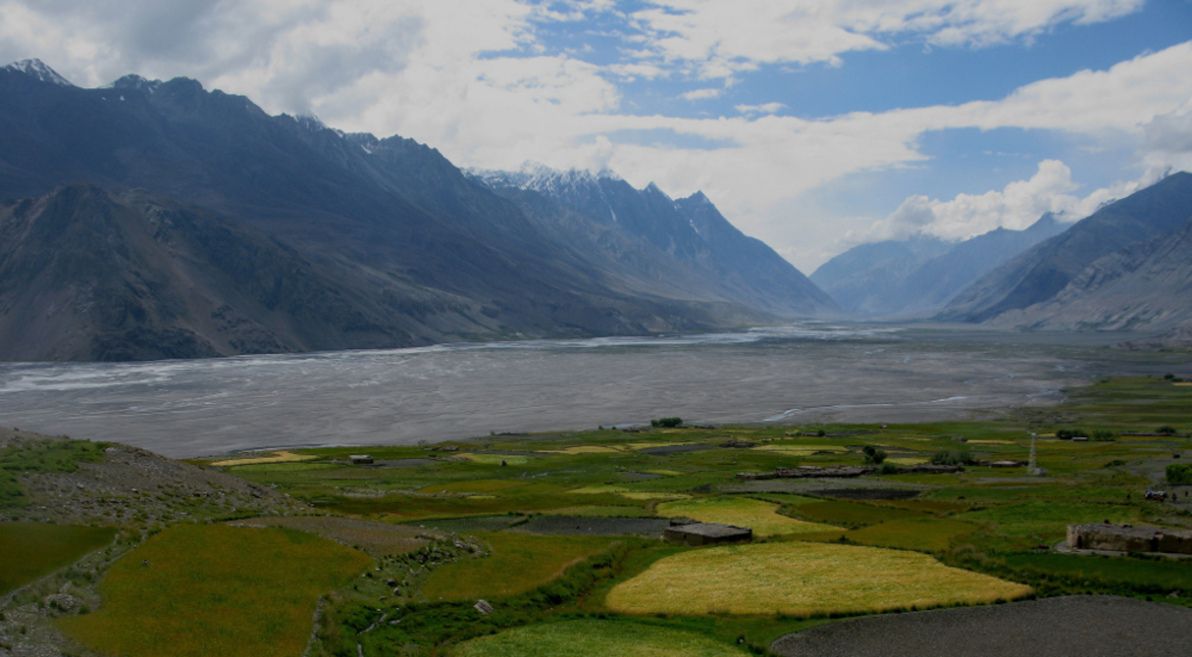
The source of the Oxus is the Wakhan river, which begins at Baza'i Gonbad at the eastern end of Afghanistan's remote Wakhan Corridor, often nicknamed "The Roof of the World". This location is only 40km from the tiny and seldom-crossed Sino-Afghan border. Although the Wakhan river valley has never been properly "civilised" – neither by ancient empires nor by modern states (its population is as rugged and nomadic today as it was millenia ago) – it has been populated continuously since ancient times.
Next in line downstream is the Panj river, which begins where the Wakhan and Pamir rivers meet. For virtually its entire length, the Panj follows the Afghanistan-Tajikistan border; and it winds a zig-zag course through rugged terrain for much of its course, until it leaves behind the modern-day Badakhstan province towards its end. Like the Wakhan, the mountainous upstream part of the Panj was never truly conquered; however, the more accessible downstream part was the eastern frontier of ancient Bactria.
The Oxus proper begins where the Panj and Vakhsh rivers meet, on the Afghanistan-Tajikistan border. It continues along the Afghanistan-Uzbekistan border, and then along the Afghanistan-Turkmenistan border, until it enters Turkmenistan where the modern-day Karakum Canal begins. The river's course has been fairly stable along this part of the route throughout recorded history, although it has made many minor deviations, especially further downstream where the land becomes flatter. This part of the river was the Bactrian heartland in antiquity.
The rest of the river's route – mainly through Turkmenistan, but also hugging the Uzbek border in sections, and finally petering out in Uzbekistan – traverses the flat, arid Karakum Desert. The course and strength of the river down here has changed constantly over the centuries; for this reason, the Oxus has earned the nickname "the mad river". In ancient times, the Uzboy river branched off from the Oxus in northern Turkmenistan, and ran west across the desert until (arguably) emptying into the Caspian Sea. However, the strength of the Uzboy gradually lessened, until the river completely perished approximately 400 years ago. It appears that the Uzboy was considered part of the Oxus (and was given no name of its own) by many ancient geographers.
The Oxus proper breaks up into an extensive delta once in Uzbekistan; and for most of recorded history, it emptied into the Aral Sea. However, due to an aggressive Soviet-initiated irrigation campaign since the 1950s (the culmination of centuries of Russian planning and dreaming), the Oxus delta has rescinded significantly, and the river's waters fizzle out in the desert before reaching the sea. This is one of the major causes of the death of the Aral Sea, one of the worst environmental disasters on the planet.
Although geographically separate, the nearby Murghab river is also an important part of the cultural and archaeological story of the Oxus region (its lower reaches in modern-day Turkmenistan, at least). From its confluence with the Kushk river, the Murghab meanders gently down through semi-arid lands, before opening into a large delta that fans out optimistically into the unforgiving Karakum desert. The Murghab delta was in ancient times the heartland of Margiana, an advanced civilisation whose heyday largely predates that of Bactria, and which is home to some of the most impressive (and under-appreciated) archaeological sites in the region.
I won't be covering it in this article, as it's a whole other landscape and a whole lot more history; nevertheless, I would be remiss if I failed to mention the "sister" of the Oxus, the Syr Darya river, which was in antiquity known by its Greek name as the Jaxartes, and which is the other major artery of Central Asia. The source of the Jaxartes is (according to some) not far from that of the Oxus, high up in the Pamir mountains; from there, it runs mainly north-west through Kyrgyzstan, Uzbekistan, and then (for more than half its length) Kazakhstan, before approaching the Aral Sea from the east. Like the Oxus, the present-day Jaxartes also peters out before reaching the Aral; and since these two rivers were formerly the principal water sources of the Aral, that sea is now virtually extinct.
Hyrcania
Having finished tracing the rivers' paths from the mountains to the desert, I will now – Much like the documentary – explore the region's ancient realms the other way round, beginning in the desert lowlands.
The heartland of Hyrcania (more often absorbed into a map of ancient Parthia, than given its own separate mention) – in ancient times just as in the present-day – is Golestan province, Iran, which is a fertile and productive area on the south-west shores of the Caspian. This part of Hyrcania is actually outside of the Oxus region, and so falls off this article's radar. However, Hyrcania extended north into modern-day Turkmenistan, reaching the banks of the then-flowing Uzboy river (which was ambiguously referred to by Greek historians as the "Ochos" river).
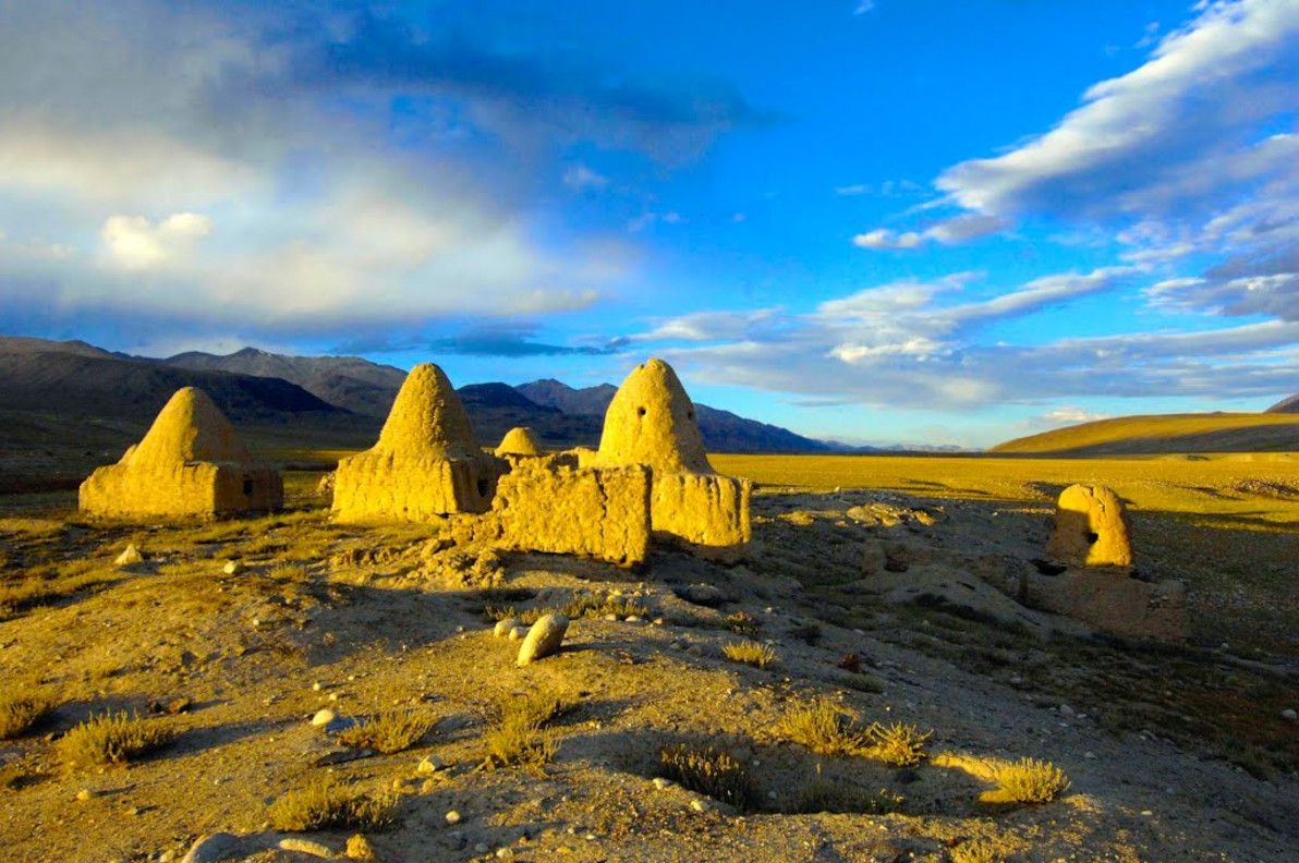
Settlements along the lower Uzboy part of Hyrcania (which was on occasion given a name of its own, Nesaia) were few. The most notable surviving ruin there is the Igdy Kala fortress, which dates to approximately the 4th century BCE, and which (arguably) exhibits both Parthian and Chorasmian influence. Very little is known about Igdy Kala, as the site has seldom been formally studied. The question of whether the full length of the Uzboy ever existed remains unresolved, particularly regarding the section from Sarykamysh Lake to Igdy Kala.
By including Hyrcania in the Oxus region, I'm tentatively siding with those that assert that the "greater Uzboy" did exist; if it didn't (i.e. if the Uzboy finished in Sarykamysh Lake, and if the "lower Uzboy" was just a small inlet of the Caspian Sea), then the extent of cultural interchange between Hyrcania and the actual Oxus realms would have been minimal. In the documentary, narrator David Adams is quite insistent that the Oxus was connected to the Caspian in antiquity, making frequent reference to the works of Patrocles; while this was quite convenient for the documentary's hypothesis that the Oxo-Caspian was a major trade route, the truth is somewhat less black-and-white.
Chorasmia
North-east of Hyrcania, crossing the lifeless Karakum desert, lies Chorasmia, better known for most of its history as Khwarezm. Chorasmia lies squarely within the Oxus delta; although the exact location of its capitals and strongholds has shifted considerably over the centuries, due to political upheavals and due to changes in the delta's course. In antiquity (particularly in the 4th and 3rd centuries BCE), Chorasmia was a vassal state of the Achaemenid Persian empire, much like the rest of the Oxus region; the heavily Persian-influenced language and culture of Chorasmia, which can still be faintly observed in modern times, harks back to this era.
This region was strongest in medieval times, and its medieval capital at the present-day ghost city of Konye-Urgench – known in its heyday as Gurganj – was Chorasmia's most significant seat of power. Gurganj was abandoned in the 16th century CE, when the Oxus changed course and left the once-fertile city and surrounds without water.
It's unknown exactly where antiquity-era Chorsamia was centred, although part of the ruins of Kyrk Molla at Gurganj date back to this period, as do part of the ruins of Itchan Kala in present-day Khiva (which was Khwarezm's capital from the 17th to the 20th centuries CE). Probably the most impressive and best-preserved ancient ruins in the region, are those of the Ayaz Kala fortress complex, parts of which date back to the 4th century BCE. There are numerous other "Kala" (the Chorasmian word for "fortress") nearby, including Toprak Kala and Kz'il Kala.
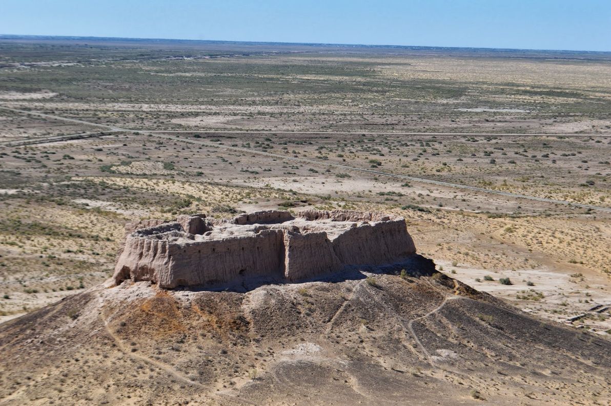
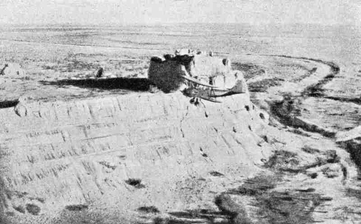
One of the less-studied sites – but by no means a less significant site – is Dev-kesken Kala, a fortress lying due west of Konye-Urgench, on the edge of the Ustyurt Plateau, overlooking the dry channel of the former upper Uzboy river. Much like Konye-Urgench (and various other sites in the lower Oxus delta), Dev-kesken Kala was abandoned when the water stopped flowing, in around the 16th century CE. The city was formerly known as Vazir, and it was a thriving hub of medieval Khwarezm. Also like other sites, parts of the fortress date back to the 4th century BCE.
I should also note that Dev-kesken Kala was one of the most difficult archaeological sites (of all the sites I'm describing in this article) to find information online for. I even had to create the Dev-Kesken Wikipedia article, which previously didn't exist (my first time creating a brand-new page there). The site was also difficult to locate on Google Earth (should now be easier, the co-ordinates are saved on the Wikipedia page). The site is certainly under-studied and under-visited, considering its distinctive landscape and its once-proud history; however, it is remote and difficult to access, and I understand that this Uzbek-Turkmen frontier area is also rather unsafe, due to an ongoing border dispute.
Margiana
South of Chorasmia – crossing the Karakum desert once again – one will find the realm that in antiquity was known as Margiana (although that name is simply the hellenised version of the original Persian name Margu). Much like Chorasmia, Margiana is centred on a river delta in an otherwise arid zone; in this case, the Murghab delta. And like the Oxus delta, the Murghab delta has also dried up and rescinded significantly over the centuries, due to both natural and human causes. Margiana lies within what is present-day southern Turkmenistan.
Although the Oxus doesn't run through Margiana, the realm is nevertheless part of the Oxus region (more surely so than Hyrcania, through which a former branch of the Oxus arguably runs), for a number of reasons. Firstly, it's geographically quite close to the Oxus, with only about 200km of flat desert separating the two. Secondly, the Murghab and the Oxus share many geographical traits, such as their arid deltas (as mentioned above), and also their habit of frequently and erratically changing course. Lastly, and most importantly, there is evidence of significant cultural interchange between Margiana and the other Oxus realms throughout civilised history.
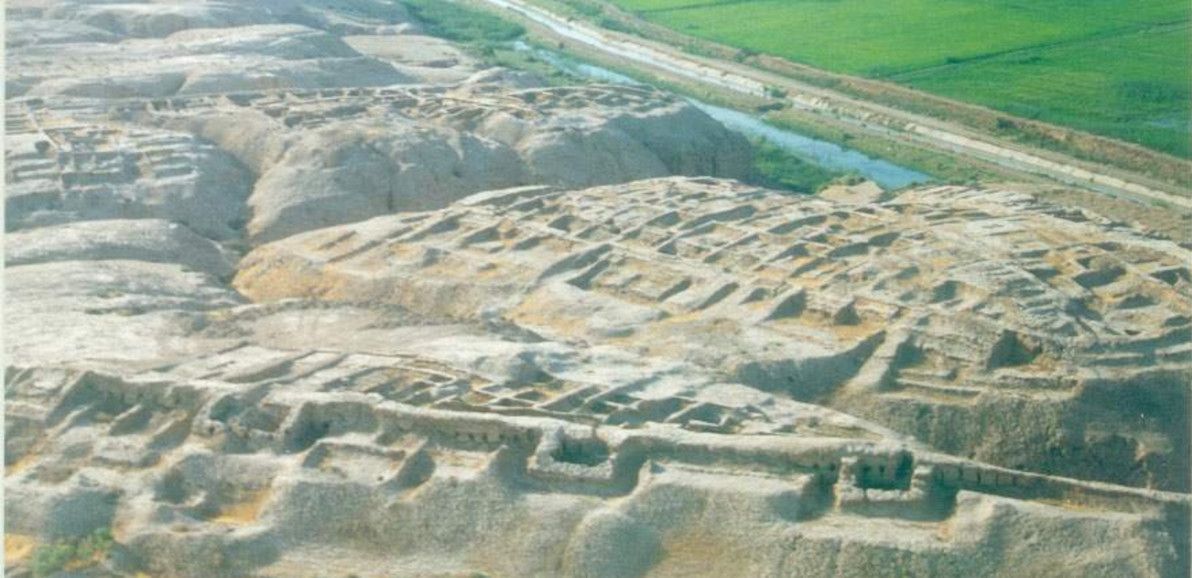
The political centre of Margiana – in the antiquity period and for most of the medieval period, too – was the city of Merv, which was known then as Gyaur Kala (and also briefly by its hellenised name, Antiochia Margiana). Today, Merv is one of the largest and best-preserved archaeological sites in all the Oxus region, although most of the visible ruins are medieval, and the older ruins still lie largely buried underneath. The site has been populated since at least the 5th century BCE.
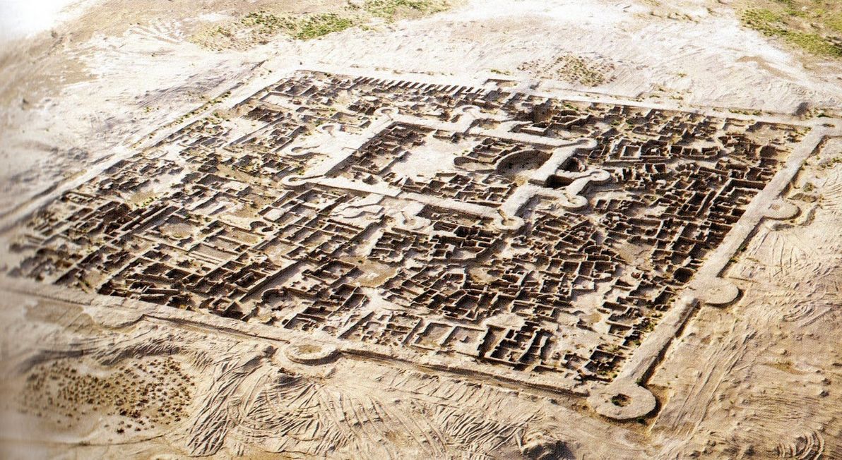
Although Merv was Margiana's capital during the Persian and Greek periods, the site of most significance around here is the far older Gonur Tepe. The site of Gonur was completely unknown to modern academics until the 1970s, when the legendary Soviet archaeologist Viktor Sarianidi discovered it (Sarianidi sadly passed away less than a year ago, aged 84). Gonur lies in what is today the parched desert, but what was – in Gonur's heyday, in approximately 2,000 BCE – well within the fertile expanse of the then-greater Murghab delta.
The vast bronze age complex of Gonur Tepe. Image source:Boskawola.
Gonur was one of the featured sites in the documentary series – and justly so, because it's the key site of the so-called Bactria-Margiana Archaeological Complex. It's also a prime example of a "forgotten realm" in the region: to this day, few tourists and journalists have ever visited it (David Adams and his crew were among those that have made the arduous journey); and, apart from Sarianidi (who dedicated most of his life to studying Gonur and nearby ruins), few archaeologists have explored the site, and insufficient effort is being made by authorities and by academics to preserve the crumbling ruins. All this is a tragedy, considering that some have called for bronze-age Margiana to be added to the list of the classic "cradles of civilisation", which includes Egypt, Babylon, India, and China.
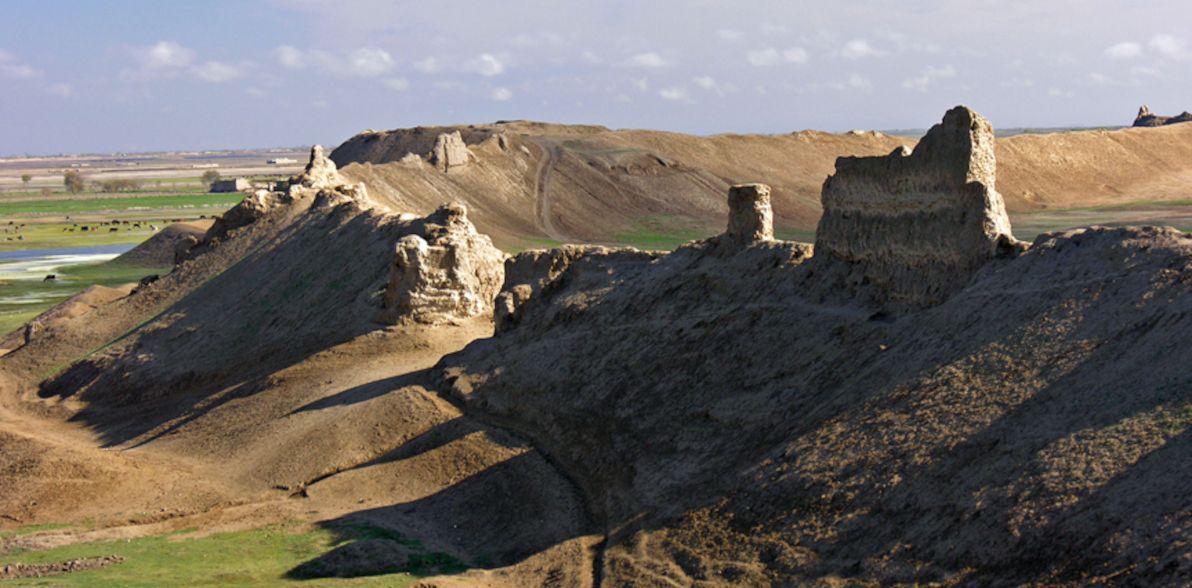
There are many other ruins in Margiana that were part of the bronze-age culture centred in Gonur. One of the other more promiment sites is Altyn Tepe, which lies about 200km south-west of Gonur, still within Turkmenistan but close to the Iranian border. Altyn Tepe, like Gonur, reached its zenith around 2,000 BCE; the site is characterised by a large Babylon-esque ziggurat. Altyn Tepe was also studied extensively by Sarianidi; and it too has been otherwise largely overlooked during modern times.
Sogdiana
Crossing the Karakum desert again (for the last time in this article) – heading north-east from Margiana – and crossing over to the northern side of the Oxus river, one may find the realm that in antiquity was known as Sogdiana (or Sogdia). Sogdiana principally occupies the area that is modern-day southern Uzbekistan and western Tajikistan.
The Sogdian heartland is the fertile valley of the Zeravshan river (old Persian name), which was once known by its Greek name, as the Polytimetus, and which has also been called the Sughd, in honour of its principal inhabitants (modern-day Tajikistan's Sughd province, through which the river runs, likewise honours them).
The Zeravshan's source is high in the mountains near the Tajik-Kyrgyz border, and for its entire length it runs west, passing through the key ancient Sogdian cities of Panjakent, Samarkand (once known as Maracanda), and Bukhara (which all remain vibrant cities to this day), before disappearing in the desert sands approaching the Uzbek-Turkmen border. The Zeravshan probably reached the Oxus and emptied into it – once upon a time – near modern-day Türkmenabat, which in antiquity was known as Amul, and in medieval times as Charjou. For most of its history, Amul lay just beyond the frontiers of Sogdiana, and it was the crossroads of all the principal realms of the Oxus region mentioned in this article.
Although Sogdiana is an integral part of the Oxus region, and although it was a dazzling civilisation in antiquity (indeed, it was arguably the most splendid of all the Oxus realms), I'm only mentioning it in this article for completeness, and I will refrain from exploring its archaeology in detail. (You may also have noted that the Zeravshan river and the Sogdian cities are missing from my custom map of the region). This is because I don't consider Sogdiana to be "forgotten", in anywhere near the sense that the other realms are "forgotten".
The key Sogdian sites – particularly Samarkand and Bukhara, which are both today UNESCO-listed – enjoy international fame; they have been studied intensively by modern academics; and they are the biggest tourist attractions in all of Central Asia. Apart from Sogdiana's prominence in Silk Road history, and its impressive and well-preserved architecture, the relative safety and stability of Uzbekistan – compared with its fellow Oxus-region neighbours Turkmenistan, Tajikistan, and Afghanistan – has resulted in the Sogdian heartland receiving the attention it deserves from the curious modern world.
Also – putting aside its "not forgotten" status – the partial exclusion (or, perhaps more accurately, the ambivalent inclusion) of Sogdiana from the Oxus region has deep historical roots. Going back to Achaemenid Persian times, Sogdiana was the extreme northern frontier of Darius's empire. And when the Greeks arrived and began to exert their influence, Sogdiana was known as Transoxiana, literally meaning "the land across the Oxus". Thus, from the point of view of the two great powers that dominated the region in antiquity – the Persians and the Greeks – Sogdiana was considered as the final outpost: a buffer between their known, civilised sphere of control; and the barbarous nomads who dwelt on the steppes beyond.
Bactria
Finally, after examining the other realms of the Oxus region, we come to the land that was the region's showpiece in the antiquity period: Bactria. The Bactrian heartland can be found south of Sogdiana, separated from it by the (relatively speaking) humble Chul'bair mountain range. Bactria occupies a prime position along the Oxus river: that is, it's the first section lying downstream of overly-rugged terrain; and it's upstream enough that it remains quite fertile to this day, although it's significantly less fertile than it was millennia ago. Bactria falls principally within modern-day northern Afghanistan; but it also encroaches into southern Uzbekistan and Tajikistan.
Historians know more about antiquity-era Bactria than they do about the rest of the Oxus region, primarily because Bactria was better incorporated into the great empires of that age than were its neighbours, and therefore far more written records of Bactria have survived. Bactria was a semi-autonomous satrapy (province) of the Persian empire since at least the 6th century BCE, although it was probably already under Persian influence well before then. It was conquered by Alexander the Great in 328 BCE (after he had already marched through Sogdiana the year before), thus marking the start of Greco-Bactrian rule, making Bactria the easternmost hellenistic outpost of the ancient world.
However, considering its place in the narrative of these empires, and considering its being recorded by both Persian and Greek historians, surprisingly little is known about the details of ancient Bactria today. This is why the documentary was called "Alexander's Lost World". Much like its neighbours, the area comprising modern-day Bactria is relatively seldom visited and seldom studied, due to its turbulent recent history.
The first archaeological site that I'd like to discuss in this section is that of Kampyr Tepe, which lies on the northern bank of the Oxus (putting it within Uzbek territory), just downstream from modern-day Termez. Kampyr Tepe was constructed around the 4th century BCE, possibly initially as a garrison by Alexander's forces. It was a thriving city for several centuries after that. It would have been an important defensive stronghold in antiquity, lying as it does near the western frontier of Bactria proper, not far from the capital, and affording excellent views of the surrounding territory.
There is evidence that a number of different religious groups co-existed peacefully in Kampyr Tepe: relics of Hellenism, Zoroastrianism, and Buddhism from similar time periods have been discovered here. The ruins themselves are in good condition, especially considering the violence and instability that has affected the site's immediate surroundings in recent history. However, the reason for the site's admirable state of preservation is also the reason for its inaccessibility: due to its border location, Kampyr Tepe is part of a sensitive Uzbek military-controlled zone, and access is highly restricted.
The capital of Bactria was the grand city of Bactra, the location of which is generally accepted to be a circular plateau of ruins touching the northern edge of the modern-day city of Balkh. These lie within the delta of the modern-day Balkh river (once known as the Bactrus river), about 70km south of where the Oxus presently flows. In antiquity, the Bactrus delta reached the Oxus and fed into it; but the modern-day Balkh delta (like so many other deltas mentioned in this article) fizzles out in the sand.
Today, the most striking feature of the ruins is the 10km-long ring of thick, high walls enclosing the ancient city. Balkh is believed to have been inhabited since at least the 27th century BCE, although most of the archaeological remains only date back to about the 4th century BCE. The ruins at Balkh are currently on UNESCO's tentative World Heritage list. It's likely that the plateau at Balkh was indeed ancient Bactra; however, this has never been conclusively proven. Modern archaeologists barely had any access to the site until 2003, due to decades of military conflict in the area. To this day, access continues to be highly restricted, for security reasons.
The formidable walls surrounding the ruins of Bactra, adjacent to modern-day Balkh. Image source:Hazara Association of UK.
Bactria was an important centre of Zoroastianism, and Bactra is one of (and is the most likely of) several contenders claiming to be the home of the mythical prophet Zoroaster. Tentatively related to this, is the fact that Bactra was also (possibly) once known as Zariaspa. A few historians have gone further, and have suggested that Bactra and Zariaspa were two different cities; if this is the case, then a whole new can of worms is opened, because it begs a multitude of further questions. Where was Zariaspa? Was Bactra at Balkh, and Zariaspa elsewhere? Or were Bactra and Zariaspa actually the same city… but located elsewhere?
Based on the theory of Ptolemy (and perhaps others), in the documentary David Adams strongly hypothesises that: (a) Bactra and Zariaspa were twin cities, next to each other; (b) the twin-city of Bactra-Zariaspa was located somewhere on the Oxus north of Balkh (he visits and proposes such a site, which I believe was somewhere between modern-day Termez and Aiwanj); and (c) this site, rather than Balkh, was the capital of the Greco-Bactrian kingdom that followed Alexander's conquest. While this is certainly an interesting hypothesis – and while it's true that there hasn't been nearly enough excavation or analysis done in modern times to rule it out – the evidence and the expert opinion, as it stands today, would suggest that Adams's hypothesis is wrong. As such, I think that his assertion of "the lost city of Bactra-Zariaspa" lying on the Oxus, rather than in the Bactrus delta, was stated rather over-confidently and with insufficient disclaimers in the documentary.
Upper Bactria
Although not historically or culturally distinct from the Bactrian heartland, I'm analysing "Upper Bactria" (i.e. the part of Bactria upstream of modern-day Balkh province) separately here, primarily to maintain structure in this article, but also because this farther-flung part of the realm is geographically quite rugged, in contrast to the heartland's sweeping plains.
First stop in Upper Bactria is the archaeological site of Takhti Sangin. This ancient ruin can be found on the Tajik side of the border; and since it's located at almost the exact spot where the Panj and Vakhsh rivers meet to become the Oxus, it could also be said that Takhti Sangin is the last site along the Oxus proper that I'm examining. However, much like the documentary, I'll be continuing the journey further upstream to the (contested) "source of the Oxus".
The principal structure at Takhti Sangin was a large Zoroastrian fire temple, which in its heyday boasted a pair of constantly-burning torches at its main entrance. Most of the remains at the site date back to the 3rd century BCE, when it became an important centre in the Greco-Bactrian kingdom (and when it was partially converted into a centre of Hellenistic worship); but the original temple is at least several centuries older than this, as attested to by various Achaemenid Persian-era relics.
Takhti Sangin is also the place where the famous "Oxus treasure" was discovered in the British colonial era (most of the treasure can be found on display at the British Museum to this day). In the current era, visitor access to Takhti Sangin is somewhat more relaxed than is access to the Bactrian sites further downstream (mentioned above) – there appear to be tour operators in Tajikistan running regularly-scheduled trips there – but this is also a sensitive border area, and as such, access is controlled by the Tajik military (who maintain a constant presence). Much like the sites of the Bactrian heartland, Takhti Sangin has been studied only sporadically by modern archaeologists, and much remains yet to be clarified regarding its history.
Moving further upstream, to the confluence of the Panj and Kokcha rivers, one reaches the site of Ai-Khanoum (meaning "Lady Moon" in modern Uzbek), which is believed (although not by all) to be the legendary city that was known in antiquity as Alexandria Oxiana. This was the most important Greco-Bactrian centre in Upper Bactria: it was built in the 3rd century BCE, and appears to have remained relatively vibrant for several centuries thereafter. It's also the site furthest upstream on the Oxus, for which there is significant evidence to indicate a Greco-Bactrian presence. It's a unique site within the Oxus region, in that it boasts the typical urban design of a classical Greek city; it's virtually "a little piece of Greece" in Central Asia. It even housed an amphitheatre and a gymnasium.
Ai-Khanoum certainly qualifies as a "lost" city: it was unknown to all save some local tribespeople, until the King of Afghanistan chanced upon it during a hunting trip in 1961. Due primarily to the subsequent Afghan-Soviet war, the site has been poorly studied (and also badly damaged) since then. In the documentary, it's explained how (and illustrated with some impressive 3D animation) – according to some – the Greco-Bactrian city was built atop the ruins of an older city, probably of Persian origin, which was itself once a dazzling metropolis. The documentary also indicates that access to Ai-Khanoum is currently tricky, and must be coordinated with the Afghan military; the site itself is also difficult to physically reach, as it's basically an island amongst the rivers that converge around it, depending on seasonal fluctuations.
The final site that I'd like to discuss regarding the realm of Bactria, is that of Sar-i Sang (a name meaning "place of stone"). At this particularly remote spot in the mountains of Badakhstan, there barely exists a town, neither today nor in ancient times. The nearest settlement of any size is modern-day Fayzabad, the provincial capital. From Ai-Khanoum, the Kokcha river winds upstream and passes through Fayzabad; and from there, the Kokcha valley continues its treacherous path up into the mountains, with Sar-i Sang located about 100km's south of Fayzabad.
Sar-i Sang is not a town, it's a mine: at an estimated 7,000 years of age, it's believed to be the oldest continuously-operating mine in the world. Throughout recorded history, people have come here seeking the beautiful precious stone known as lapis lazuli, which exists in veins of the hillsides here in the purest form and in the greatest quantity known on Earth.
Although Sar-i Sang (also known as Darreh-Zu) is quite distant from all the settlements of ancient Bactria (and quite distant from the Oxus), the evidence suggests that throughout antiquity the Bactrians worked the mines here, and that lapis lazuli played a significant role in Bactria's international trade. Sar-i Sang lapis lazuli can be found in numerous famous artifacts of other ancient empires, including the tomb of Tutankhamun in Egypt. Sources also suggest that this distinctive stone was Bactria's most famous export, and that it was universally associated with Bactria, much like silk was associated with China.
The Wakhan
Having now discussed the ancient realms of the Oxus from all the way downstream in the hot desert plains, there remains only one segment of this epic river left to explore: its source far upstream. East of Bactria lies one of the most inaccessible, solitary, and unspoiled places in the world: the Wakhan Corridor. Being the place where a number of very tall mountain ranges meet – among them the Pamirs, the Hindu Kush, and the Karakoram – the Wakhan has often been known as "The Roof of the World".
The Wakhan today is a long, slim "panhandle" of territory within Afghanistan, bordered to the north by Tajikistan, to the south by Pakistan, and to the east by China. This distinctive borderline was a colonial-era invention, a product of "The Great Game" played out between Imperial Russia and Britain, designed to create a buffer zone between these powers. Historically, however, the Wakhan has been nomadic territory, belonging to no state or empire, and with nothing but the immensity of the surrounding geography serving as its borders (as it continues to be on the ground to this day). The area is also miraculously bereft of the scourges of war and terrorism that have plagued the rest of Afghanistan in recent years.
Much like the documentary, my reasons for discussing the Wakhan are primarily geographic ones. The Wakhan is centred around a single long valley, whose river – today known as the Panj, and then higher up as the Wakhan river – is generally recognised as the source of the Oxus. It's important to acknowledge this high-altitude area, which plays such an integral role in feeding the river that diverse cultures further downstream depend upon, and which has fuelled the Oxus's long and colourful history.
There are few significant archaeological sites within the Wakhan. The ancient Kaakha fortress falls just outside the Wakhan proper, at the extreme eastern-most extent of the influence of antiquity-era kingdoms in the Oxus region. The only sizeable settlement in the Wakhan itself is the village of Sarhad, which has been continuously inhabited for millennia, and which is the base of the unique Wakhi people, who are the Wakhan's main tribe (Sarhad is also where the single rough road along the Wakhan valley ends). Just next to Sarhad lies the Kansir fort, built by the Tibetan empire in the 8th century CE, a relic of the battle that the Chinese and Tibetan armies fought in the Wakhan in the year 747 CE (this was probably the most action that the Wakhan has ever seen in its history).
Close to the very spot where the Wakhan river begins is Baza'i Gonbad (or Bozai Gumbaz, in Persian "domes of the elders"), a collection of small, ancient mud-brick domes about which little is known. As there's nothing else around for miles, they are occasionally used to this day as travellers' shelters. They are believed to be the oldest structures in the Wakhan, but it's unclear who built them (it was probably one of the nomadic Kyrgyz tribes that roam the area), or when.
Regarding which famous people have visited the Wakhan throughout history: it appears almost certain that Marco Polo passed through the Wakhan in the 13th century CE, in order to reach China; and a handful of other Europeans visited the Wakhan in the subsequent centuries (and it's almost certain that the only "tourists" to ever visit the Wakhan are those of the past century or so). In the documentary, David Adams suggests repeatedly in the final episode (that in which he journeys to the Wakhan) that Alexander – either the man himself, or his legions – not only entered the Wakhan Corridor, but even crossed one of its high passes over to Pakistan. I've found no source to clearly corroborate this claim; and after posing the question to a forum of Alexander-philes, it appears quite certain that neither Alexander nor his legions ever set foot in the Wakhan.
Conclusion
So, there you have it: my humble overview of the history of a region ruled by rivers, empires, and treasures. As I've emphasied throughout this article, the Oxus region is most lamentably a neglected and under-investigated place, considering its colourful history and its rich tapestry of cultures and landscapes. My aim in writing this piece is simply to inform anyone else who may be interested, and to better preserve the region's proud legacy.
I must acknowledge and wholeheartedly thank David Adams and his team for producing the documentary Alexander's Lost World, which I have referred to throughout this article, and whose material I have re-analysed as the basis of my writings here. The series has been criticised by history buffs for its various inaccuracies and unfounded claims; and I admit that I too, in this article, have criticised it several times. However, despite this, I laud the series' team for producing a documentary that I enjoyed immensely, and that educated me and inspired me to research the Oxus region in-depth. Like the documentary, this article is about rivers and climate change as the primary forces of the region, and Alexander the Great (along with other famous historical figures) is little more than a sidenote to this theme.
I am by no means an expert on the region, nor have I ever travelled to it (I have only "vicariously" travelled there, by watching the documentary and by writing this article!). I would love to someday set my own two feet upon the well-trodden paths of the Oxus realms, and to see these crumbling testaments to long-lost g-ds and kings for myself. For now, however, armchair history blogging will have to suffice.
]]>
Current state of the Cape to Cairo Railway2013-08-01T00:00:00Z2013-08-01T00:00:00ZJazahttps://greenash.net.au/thoughts/2013/08/current-state-of-the-cape-to-cairo-railway/
In the late 19th century, the British-South-African personality Cecil Rhodes dreamed of a complete, uninterrupted railway stretching from Cape Town, South Africa, all the way to Cairo, Egypt. During Rhodes's lifetime, the railway extended as far north as modern-day Zimbabwe – which was in that era known by its colonial name Rhodesia (in honour of Rhodes, whose statesmanship and entrepreneurism made its founding possible). A railway traversing the entire north-south length of Africa was an ambitious dream, for an ambitious man.
Rhodes's dream remains unfulfilled to this day.
The famous "Rhodes Colossus", superimposed upon the present-day route of the Cape to Cairo Railway. "The Rhodes Colossus" illustration originally from Punch magazine, Vol. 103, 10 Dec 1892; image courtesy of Wikimedia Commons. Africa satellite image courtesy of Google Earth.
Nevertheless, significant additions have been made to Africa's rail network during the interluding century; and, in fact, only a surprisingly small section of the Cape to Cairo route remains bereft of the Iron Horse's footprint.
Although both information about – (a) the historical Cape to Cairo dream; and (b) the history / current state of the route's various railway segments – abound, I was unable to find any comprehensive study of the current state of the railway in its entirety.
This article, therefore, is an endeavour to examine the current state of the full Cape to Cairo Railway. As part of this study, I've prepared a detailed map of the route, which marks in-service sections, abandoned sections, and missing sections. The map has been generated from a series of KML files, which I've made publicly available on GitHub, and for which I welcome contributions in the form of corrections / tweaks to the route.
Southern section
As its name suggests, the line begins in Cape Town, South Africa. The southern section of the railway encompasses South Africa itself, along with the nearby countries that have historically been part of the South African sphere of influence: that is, Botswana, Zimbabwe, and Zambia.
Southern section of the Cape to Cairo Railway: Cape Town to Kapiri Mposhi.
The first segment – Cape Town to Johannesburg – is also the oldest, the best-maintained, and the best-serviced part of the entire route. The first train travelled this segment in 1892. There has been continuous service ever since. It's the only train route in all of Africa that can honestly claim to provide a "European standard" of passenger service, between the two major cities that it links. That is, there are numerous classes of service operating on the line – ranging from basic inter-city commuter trains, to business-style fast trains, to luxury sleeper trains – running several times a day.
So, the first leg of the railway is the one that we should be least worried about. Hence, it's marked in green on the map. This should come as no surprise, considering that South Africa has the best-developed infrastructure in all of Africa (by a long shot), as well as Africa's largest economy.
After Johannesburg, we continue along the railway that was already fulfilling Cecil Rhodes's dream before his death. This segment runs through modern-day Botswana, which was previously known as Bechuanaland Protectorate. From Johannesburg, it connects to the city of Mafeking, which was the capital of the former Bechuanaland Protectorate, but which today is within South Africa (where it is a regional capital). The line then crosses the border into Botswana, passes through the capital Gaborone, and continues to the city of Francistown in Botswana's north-east.
Unfortunately, since the opening of the Beitbridge Bulawayo Railway in Zimbabwe in 1999 (providing a direct train route between Zimbabwe and South Africa for the first time), virtually all regular passenger service on this segment (and hence, virtually all regular passenger service on Botswana's train network) has been cancelled. The track is still being maintained, and (apart from some freight trains) there are still occasional luxury tourist trains using the route. However, it's unclear if there are still any regular passenger services between Johannesburg and Mafeking (if there are, they're very few); and sources indicate that there are no regular passenger services at all between Mafeking and Francistown. Hence, the segment is marked in yellow on the map.
(I should also note that the new direct train route from South Africa to Zimbabwe, does actually provide regular passenger service, from Johannesburg to Messina, and then from Beitbridge to Bulawayo, with service missing only in the short border crossing between Messina and Beitbridge. However, I still consider the segment via Botswana to be part of the definitive "Cape to Cairo" route: because of its historical importance; and because only quite recently has service ceased on this segment and has an alternative segment been open.)
From Francistown onwards, the situation is back in the green. There is a passenger train from Francistown to Bulawayo, that runs three times a week. I should also mention here, that Bulawayo is quite a significant spot on the Cape to Cairo Railway, as (a) the grave of Cecil Rhodes can be found atop "World's View", a panoramic hilltop in nearby Matobo National Park; and (b) Bulawayo was the first city that the railway reached in (former) Rhodesia, and to this day it remains Zimbabwe's rail hub. Bulawayo is also home to a railway museum.
For the remainder of the route through Zimbabwe, the line remains in the green. There's a daily passenger service from Bulawayo to Victoria Falls. Sadly, this spectacular leg of the route has lost much of its former glory: due to Zimbabwe's recent economic and political woes, the trains are apparently looking somewhat the worse for wear. Nevertheless, the service continues to be popular and reasonably reliable.
The green is briefly interrupted by a patch of yellow, at the border crossing between Zimbabwe and Zambia. This is because there has been no passenger service over the famous Victoria Falls Bridge – which crosses the Zambezi River at spraying distance from the colossal waterfall, connecting the towns of Victoria Falls and Livingstone – more-or-less since the 1970s. Unless you're on board one of the infrequent luxury tourist trains that still traverse the bridge, it must be crossed on foot (or using local transport). It should also be noted that although the bridge is still most definitely intact and looking solid, it's more than 100 years old, and experts have questioned whether it's receiving adequate care and maintenance.
Victoria Falls Bridge: a marvel of modern engineering, straddles one of the world's natural wonders. Image sourced from: Car Hire Victoria Falls.
Once in Zambia – formerly known as Northern Rhodesia – regular passenger services continue north to the capital, Lusaka; and from there, onward to the crossroads town of Kapiri Mposhi. It's here that the southern portion of the modern-day Cape to Cairo railway ends, since Kapiri Mposhi is the meeting-point of the colonial-era, British-built, South-African / Rhodesian railway network, and a modern-era East-African rail link that was unanticipated in Rhodes's plan.
I should also mention here that the colonial-era network continues north from Kapiri Mposhi, crossing the border with modern-day DR Congo (formerly known as the Belgian Congo), and continuing up to the shores of Lake Tanganyika, where it terminates at the town of Kalemie. The plan in the colonial era was that the Cape to Cairo passenger link would continue north via the Great Lakes in this region of Africa – in the form of lake / river ferries, up to Lake Albert, on the present-day DR Congo / Ugandan border – after which the rail link would resume, up to Egypt via Sudan.
However, I don't consider this segment to be part of the definitive "Cape to Cairo" route, because: (a) further rail links between the Great Lakes, up to Lake Albert, were never built; (b) the line running through eastern DR Congo, from the Zambian border to Kalemie on Lake Tanganyika, is apparently in serious disrepair; and (c) an alternative continuous rail link has existed, since the 1970s, via East Africa, and the point where this link terminates in modern-day Uganda is north of Lake Albert anyway. Therefore, the DR Congo – Great Lakes segment is only being mentioned here as an anecdote of history; and we now turn our attention to the East African network.
Eastern section
The Eastern section of the railway is centred in modern-day Tanzania and Kenya, although it begins and ends within the inland neighbours of these two coastal nations – Zambia and Uganda, respectively. This region, much like Southern Africa, was predominantly ruled under British colonialism in the 19th century (which is why Kenya, the region's hub, was formerly known as British East Africa). However, modern-day Tanzania (formerly called Tanganyika, before the union of Tanganyika with Zanzibar) was originally German East Africa, before becoming a British protectorate in the 20th century.
Eastern section of the Cape to Cairo Railway: Kapiri Mposhi to Gulu.
Kapiri Mposhi, in Zambia, is the start of the TAZARA Railway; this railway runs through the north-east of Zambia, crosses the border to Tanzania near Mbeya, and finishes on the Indian Ocean coast at Dar es Salaam, Tanzania's largest city.
The TAZARA is the newest link in the Cape to Cairo railway network: it was built and financed by the Chinese, and was opened in 1976. It's the only line in the network – and one of the only railway lines in all of Africa – that was built (a) by non-Europeans; and (b) in the post-colonial era. It was not envisioned by Rhodes (nor by his contemporaries), who wanted the line to pass through wholly British-controlled territory (Tanzania was still German East Africa in Rhodes's era). The Zambians wanted it, in order to alleviate their dependence (for international transport) on their southern neighbours Rhodesia and South Africa, with whom tensions were high in the 1970s, due to those nations' Apartheid governments. The line has been in regular operation since opening; hence, it's marked in green on the map.
The TAZARA: a "modern" rail link... African style. Image source: Mzuzu Transit.
Although the TAZARA line doesn't quite touch the other Tanzanian railway lines that meet in Dar es Salaam, I haven't marked any gap in the route at Dar es Salaam. This is for two reasons. Firstly, from what I can tell (by looking at maps and satellite imagery), the terminus of the TAZARA in Dar es Salaam is physically separated from the other lines, by a distance of less than two blocks, i.e. a negligible amount. Secondly, the TAZARA is (as of 1998) physically connected to the other Tanzanian railway lines, at a junction near the town of Kidatu, and there is a cargo transshipment facility at this location. However, I don't believe there's any passenger service from Kidatu to the rest of the Tanzanian network (only cargo trains). So, the Kidatu connection is being mentioned here only as an anecdote; in my opinion, the definitive "Cape to Cairo" route passes through, and connects at, Dar es Salaam.
From Dar es Salaam, the line north is part of the decaying colonial-era Tanzanian rail network. This line extends up to the city of Arusha; the part that we're interested in ends at Moshi (east of Arusha), from where another line branches off, crossing the border into Kenya. Sadly, there has been no regular passenger service on the Arusha line for many years; therefore, nor is there any service to Moshi.
After crossing the Kenyan border, the route passes through the town of Taveta, before continuing on to Voi; here, there is a junction with the most important train line in Kenya: that which connects Mombasa and Nairobi. As with the Arusha line, the Moshi – Voi line has also been bereft of regular passenger service for many years. This entire portion of the rail network appears to be in a serious state of neglect. If there are any trains running in this area, they would be occasional freight trains; and if any track maintenance is being performed on these lines, it would be the bare minimum. Therefore, the full segment from Dar es Salaam to Voi is marked in yellow on the map.
From Voi, there are regular passenger services on the main Kenyan rail line to Nairobi; and onward from Nairobi, there are further passenger services (which appear to be less reliable, but regular nonetheless) to the city of Kisumu, which borders Lake Victoria. The part of this route that we're interested in ends at Nakuru (about halfway between Nairobi and Kisumu), from where another line branches off towards Uganda. The route through Kenya, from Voi to Nakuru, is therefore in the green.
After Nakuru, the line meanders its way towards the Ugandan border; and at Tororo (a city on the Ugandan side), it connects with the Ugandan network. There is apparently no longer any passenger service available from Nakuru to Tororo – i.e. there is no service between Kenya and Uganda. As such, this segment is marked in yellow.
The once-proud Ugandan railway network today lies largely abandoned, a victim of Uganda's tragic history of dictatorship, bloodshed and economic disaster since the 1970s. The only inter-city line that maintains regular passenger service, is the main line from the capital, Kampala, to Tororo. As this line terminates at Kampala, on the shores of Lake Victoria (like the Kenyan line to Kisumu), it is of little interest to us.
From Tororo, Uganda's northern railway line stretches north and then west across the country in a grand arc, before terminating at Pakwach, the point where the Albert Nile river begins, adjacent to Lake Albert. (This line supposedly once continued from Pakwach to Arua; however, I haven't been able to find this extension marked on any maps, nor visible in any satellite imagery). The northernmost point of this railway line is at Gulu; and so, it is the segment of the line up to Gulu that interests us.
Sadly, the entire segment from Tororo to Gulu appears to be abandoned; whether there is even freight service today seems doubtful; thus, this segment is marked in yellow. And, doubly sad, Gulu is also the point at which a continuous, uninterrupted rail network all the way from Cape Town, comes to its present-day end. No rail line was ever constructed north of Gulu in Uganda. Therefore, it is at Gulu that the East African portion of the Cape to Cairo Railway bids us farewell.
Northern section
The northern section of the railway is mainly within Sudan and Egypt – although we'll be tracking (the missing section of) the route from northern Uganda; and, since 2011, the route also passes through the newly-independent South Sudan. As with its southern and eastern African counterparts, the northern part of the railway was primarily built by the British, during their former colonial rule in the region.
Northern section of the Cape to Cairo Railway: Gulu to Cairo.
We pick up from where we finished in the previous section: Gulu in northern Uganda. As has already been mentioned: from Gulu, we hit the first (of only two) – and the most significant – of the missing links in the Cape to Cairo Railway. The next point where the railway begins again, is the city of Wau, located in north-western South Sudan. Therefore, this segment of the route is marked in red on the map. In the interests of at least marking some form of transport along the missing link, the red line follows the main highway route through the region: the Ugandan A104 highway from Gulu north to the border; and from there, at the city of Nimule (just over the border in South Sudan), the South Sudanese A43 highway to Juba (the capital), and then on to Wau (this highway route is about 1,000km in total).
There has been no shortage of discussion, both past and present, regarding plans to bridge this important gap in the rail network. There have even been recent official announcements by the governments of Uganda and of South Sudan, declaring their intention to build a new rail segment from Gulu to Wau. However, there hasn't been any concrete action since the present-day railheads were established about 50 years ago; and, considering that northern Uganda / South Sudan is one of the most troubled regions in the world today, I wouldn't hold my breath waiting for any fresh steel to appear on the ground (not to mention waiting for repairs of the existing neglected / war-damaged train lines). The folks over there have plenty of other, more urgent matters to attend to.
Wau is the southern terminus of the Sudanese rail network. From Wau, the line heads more-or-less straight up, crossing the border from South Sudan into Sudan, and joining the Khartoum – Darfur line at Babanusa. The Babanusa – Wau line was one of the last train lines to be completed in Sudan, opening in 1962 (around the same time as the Tororo – Gulu – Pakwach line opened in neighbouring Uganda). I found a colourful account of a passenger journey along this line, from around 2000. As I understand it, shortly after this time, the line was damaged by mines and explosives, a victim of the civil war. The line is supposedly rehabilitated, and passenger service has ostensibly resumed – however, personally I'm not convinced that this is the case. Therefore, this segment is marked in yellow on the map.
Similarly, the remaining segment of rail onwards to the capital – Babanusa to Khartoum – was apparently damaged during the civil war (that's on top of the line's ageing and dismally-maintained state). There are supposedly efforts underway to rehabilitate this line (along with the rest of the Sudanese rail network in general), and to restore regular services along it. I haven't been able to confirm whether passenger services have yet been restored; therefore, this segment is also marked in yellow on the map.
From the Sudanese capital Khartoum, the country's principal train line traverses the rest of the route north, running along the banks of the Upper Nile for about half the route, before making a beeline across the harsh expanse of the Nubian Desert, and terminating just before the Egyptian border at the town of Wadi Halfa, on the shores of Lake Nasser (the Sudanese side of which is called Lake Nubia). Although trains do appear to get suspended for long-ish intervals, this is the best-maintained route in war-ravaged Sudan, and it appears that regular passenger services are operating from Khartoum to Wadi Halfa. Therefore, this segment is marked in green on the map.
The border crossing from Sudan into Egypt is the second of the two missing links in the Cape to Cairo Railway. In fact, there isn't even a road connecting the two nations, at least not anywhere near the Nile / Lake Nasser. However, this missing link is of less concern, because: (a) the distance is much less (approximately 350km); and (b) Lake Nasser is a large and easily navigable body of water, with regular ferry services connecting Wadi Halfa in Sudan with Aswan in Egypt. Indeed, the convenience and the efficiency of the ferry service (along with the cargo services operating on the lake) is the very reason why nobody's ever bothered to build a rail link through this segment. So, this segment is marked in red on the map: the red line more-or-less follows the ferry route over the lake.
Aswan is Egypt's southernmost city; this has been the case for millenia, since it was the southern frontier of the realm of the Pharoahs, stretching back to ancient times. Aswan is also the southern terminus of the Egyptian rail network's main line; from here, the line snakes its way north, tracing the curves of the heavily-populated Nile River valley, all the way to Cairo, after which the vast Nile Delta begins.
Train service running alongside the famous Nile River. Image source: About.com: Cruises.
The Aswan – Cairo line – the very last segment of Rhodes's grand envisioned network – is second only to the network's very first segment (Cape Town – Johannesburg) in terms of service offerings. There are a range of passenger services available, ranging from basic economy trains, to luxury tourist-oriented sleeper coaches, traversing the route daily. Although Egypt is currently in the midst of quite dramatic political turmoil (indeed, Egypt's recent military coup and ongoing protests are front-page news as I write this), as far as I know these issues haven't seriously disrupted the nation's train services. Therefore, this segment is marked in green on the map.
I should also note that after Cairo, Egypt's main rail line continues on to Alexandria on the Mediterranean coast. However, of course, the Cairo – Alexandria segment is not marked on the map, because it's a map of the Cape to Cairo railway, not the Cape to Alexandria railway! Also, Cairo could be considered to be "virtually" on the Mediterranean coast anyway, as it's connected by various offshoots of the Nile (in the Nile Delta) to the Mediterranean, with regular maritime traffic along these waterways.
End of the line
Well, there you have it: a thorough exercise in mapping and in narrating the present-day path of the Cape to Cairo Railway.
Personally, I've never been to Africa, let alone travelled any part of this long and diverse route. I'd love to do so, one day: although as I've described above, many parts of the route are currently quite a challenge to travel through, and will probably remain so for the foreseeable future. Naturally, I'd be delighted if anyone who has travelled any part of the route could share their "war stories" as comments here.
One question that I've asked myself many times, while researching and writing this article, is: in what year was the Cape to Cairo Railway at its best? (I.e. in what year was more of the line "green" than in any other year?). It would seem that the answer is probably 1976. This year was certainly not without its problems; but, at least as far as the Cape to Cairo endeavour goes, I believe that it was "as good as it's ever been".
This was the year that the TAZARA opened (which is to this day the "latest piece in the puzzle"), providing its inaugural Zambia – Tanzania service. It was one year before the 1977 dissolution of the East African Railways and Harbours Corporation, which jointly developed and managed the railways of Kenya, Uganda, and Tanzania (EAR&H's peak was probably in 1962, it was already in serious decline by 1976, but nevertheless it continued to provide comprehensive services until its end). And it was a year when Sudan's railways were in better operating condition, that nation being significantly less war-damaged than it is today (although Sudan had already suffered several years of civil war by then).
Unfortunately, it was also a year in which the Rhodesian Bush War was raging intensely – as such, on account of the hostilities between then-Rhodesia and Zambia, the Victoria Falls Bridge was largely closed to all traffic at that time (and, indeed, all travel within then-Rhodesia was probably quite difficult at that time). Then again, this hostility was also the main impetus for the construction of the TAZARA link; so, in the long-term, the tensions in then-Rhodesia actually improved the rail network more than they hampered it.
Additionally, it was a year in which Idi Amin's brutal reign of terror in Uganda was at its height. At that time, travel within Uganda was extremely dangerous, and infrastructure was being destroyed more commonly than it was being maintained.
I'm not the first person to make the observation – a fairly obvious one, after studying the route and its history – that travelling from Cape Town to Cairo overland (by train and/or by other transportation) never has been, and to this day is not, an easy expedition! There are numerous change-overs required, including change of railway guage, change to land vehicle, change to maritime vehicle, and more. The majority of the rail (and other) services along the route are poorly-maintained, prone to breakdowns, almost guaranteed to suffer extensive delays / cancellations, and vulnerable to seasonal weather fluctuations. And – as if all those "regular" hurdles weren't enough – many (perhaps the majority) of the regions through which the route passes are currently, or have in recent history been, unstable and dangerous trouble zones.
Hope you enjoyed my run-down (or should I say run-up?) of the Cape to Cairo Railway. Note that – as well as the KML files, which can be opened in Google Earth for best viewing of the route – the route is available here as a Google map.
Your contribution to the information presented here would be most welcome. If you have experience with path editing / Google Earth / KML (added bonus if you're Git / GitHub savvy, and know how to send pull requests), check out the route KML on GitHub, and feel free to refine it. Otherwise, feel free to post your route corrections, your African railway anecdotes, and all your most scathing criticism, using the comment form below (or contact me directly).
]]>
Money: the ongoing evolution2013-04-10T00:00:00Z2013-04-10T00:00:00ZJazahttps://greenash.net.au/thoughts/2013/04/money-the-ongoing-evolution/
In this article, I'm going to solve all the monetary problems of the modern world.
Oh, you think that's funny? I'm being serious.
Alright, then. I'm going to try and solve them. Money is a concept, a product and a system that's been undergoing constant refinement since the dawn of civilisation; and, as the world's current financial woes are testament to, it's clear that we still haven't gotten it quite right. That's because getting financial systems right is hard. If it were easy, we'd have done it already.
I'm going to start with some background, discussing the basics such as: what is money, and where does it come from? What is credit? What's the history of money, and of credit? How do central banks operate? How do modern currencies attain value? And then I'm going to move on to the fun stuff: what can we do to improve the system? What's the next step in the ongoing evolution of money and finance?
Disclaimer: I am not an economist or a banker; I have no formal education in economics or finance; and I have no work experience in these fields. I'm just a regular bloke, who's been thinking about these big issues, and reading up on a lot of material, and who would like to share his understandings and his conclusions with the world.
Ancient history
Money has been around for a while. When I talk about money, I'm talking cash. The stuff that leaves a smell on your fingers. The stuff that jingles in your pockets. Cold hard cash.
The earliest known example of money dates back to the 7th century BC, when the Lydians minted coins using a natural gold-based alloy called electrum. They were a crude affair – with each coin being of a slightly different shape – but they evolved to become reasonably consistent in their weight in precious metal; and many of them also bore official seals or insignias.
From Lydia, the phenomenom of minted precious-metal coinage spread: first to her immediate neighbours – the Greek and Persian empires – and then to the rest of the civilised world. By the time the Romans rose to significance, around the 3rd century BC, coinage had become the norm as a medium of exchange; and the Romans established this further with their standard-issue coins, most notably the Denarius, which were easily verifiable and reliable in their precious metal content.
Money, therefore, is nothing new. This should come as no surprise to you.
What may surprise you, however, is that credit existed before the arrival of money. How can that be? I hear you say. Isn't credit – the business of lending, and of recording and repaying a debt – a newer and more advanced concept than money? No! Quite the reverse. In fact, credit is the most fundamental concept of all in the realm of commerce; and historical evidence shows that it was actually established and refined, well before cold hard cash hit the scene. I'll elaborate further when I get on to definitions (next section). For now, just bear with me.
One of the earliest known historical examples of credit – in the form of what essentially amount to "IOU" documents – is from Ancient Babylonia:
… in ancient Babylonia … common commercial documents … are what are called "contract tablets" or "shuhati tablets" … These tablets, the oldest of which were in use from 2000 to 3000 years B. C. are of baked or sun-dried clay … The greater number are simple records of transactions in terms of "she," which is understood by archaeologists to be grain of some sort.
…
From the frequency with which these tablets have been met with, from the durability of the material of which they are made, from the care with which they were preserved in temples which are known to have served as banks, and more especially from the nature of the inscriptions, it may be judged that they correspond to the medieval tally and to the modern bill of exchange; that is to say, that they are simple acknowledgments of indebtedness given to the seller by the buyer in payment of a purchase, and that they were the common instrument of commerce.
But perhaps a still more convincing proof of their nature is to be found in the fact that some of the tablets are entirely enclosed in tight-fitting clay envelopes or "cases," as they are called, which have to be broken off before the tablet itself can be inspected … The particular significance of these "case tablets" lies in the fact that they were obviously not intended as mere records to remain in the possession of the debtor, but that they were signed and sealed documents, and were issued to the creditor, and no doubt passed from hand to hand like tallies and bills of exchange. When the debt was paid, we are told that it was customary to break the tablet.
We know, of course, hardly anything about the commerce of those far-off days, but what we do know is, that great commerce was carried on and that the transfer of credit from hand to hand and from place to place was as well known to the Babylonians as it is to us. We have the accounts of great merchant or banking firms taking part in state finance and state tax collection, just as the great Genoese and Florentine bankers did in the middle ages, and as our banks do to-day.
Source:What is Money? Original source: The Banking Law Journal, May 1913, By A. Mitchell Innes.
As the source above mentions (and as it describes in further detail elsewhere), another historical example of credit – as opposed to money – is from medieval Europe, where the split tally stick was commonplace. In particular, in medieval England, the tally stick became a key financial instrument used for taxation and for managing the Crown accounts:
A tally stick is "a long wooden stick used as a receipt." When money was paid in, a stick was inscribed and marked with combinations of notches representing the sum of money paid, the size of the cut corresponding to the size of the sum. The stick was then split in two, the larger piece (the stock) going to the payer, and the smaller piece being kept by the payee. When the books were audited the official would have been able to produce the stick with exactly matched the tip, and the stick was then surrendered to the Exchequer.
Tallies provide the earliest form of bookkeeping. They were used in England by the Royal Exchequer from about the twelfth century onward. Since the notches for the sums were cut right through both pieces and since no stick splits in an even manner, the method was virtually foolproof against forgery. They were used by the sheriff to collect taxes and to remit them to the king. They were also used by private individuals and institutions, to register debts, record fines, collect rents, enter payments for services rendered, and so forth. By the thirteenth century, the financial market for tallies was sufficiently sophisticated that they could be bought, sold, or discounted.
It should be noted that unlike the contract tablets of Babylonia (and the similar relics of other civilisations of that era), the medieval tally stick existed alongside an established metal-coin-based money system. The ancient tablets recorded payments made, or debts owed, in raw goods (e.g. "on this Tuesday, Bishbosh the Great received eight goats from Hammalduck", or "as of this Thursday, Kimtar owes five kwetzelgrams of silver and nine bushels of wheat to Washtawoo"). These societies may have, in reality, recorded most transactions in terms of precious metals (indeed, it's believed that the silver shekel emerged as the standard unit in ancient Mesopotamia); but these units had non-standard shapes and were unsigned, whereas classical coinage was uniform in shape, and possessed insignias.
In medieval England, the common currency was sterling silver, which consisted primarily of silver penny coins (but there were also silver shilling coins, and gold pound coins). The medieval tally sticks recorded payments made, or debts owed, in monetary value (e.g. "on this Monday, Lord Snottyham received one shilling and eight pence from James Yoohooson", or "as of this Wednesday, Lance Alot owes sixpence to Sir Robin").
Definitions
Enough history for now. Let's stop for a minute, and get some basic definitions clear.
First and foremost, the most basic question of all, but one that surprisingly few people have ever actually stopped to think about: what is money?
Money itself … is useless until the moment we use it to purchase or invest in something. Although money feels as if it has an objective value, its worth is almost completely subjective.
The seller and the depositor alike receive a credit, the one on the official bank and the other direct on the government treasury, The effect is precisely the same in both cases. The coin, the paper certificates, the bank-notes and the credit on the books of the bank, are all indentical in their nature, whatever the difference of form or of intrinsic value. A priceless gem or a worthless bit of paper may equally be a token of debt, so long as the receiver knows what it stands for and the giver acknowledges his obligation to take it back in payment of a debt due.
Money, then, is credit and nothing but credit. A's money is B's debt to him, and when B pays his debt, A's money disappears. This is the whole theory of money.
Source:What is Money? Original source: The Banking Law Journal, May 1913, By A. Mitchell Innes.
For some, money is a substance in which one may bathe. Image source:DuckTales…Woo-ooo!
I think the first definition is the easiest to understand. Money is a medium of exchange: it has no value in and of itself; but it allows us to more easily exchange between ourselves, things that do have value.
I think the last definition, however, is the most honest. Money is credit: or, to be more correct, money is a type of credit; a credit that is expressed in a uniform, easily quantifiable / divisible / exchangeable unit of measure (as opposed to a credit that's expressed in goats, or in bushels of wheat).
(Note: the idea of money as credit, and of credit as debt, comes from the credit theory of money, which was primarily formulated by Innes (quoted above). This is just one theory of money. It's not the definitive theory of money. However, I tend to agree with the theory's tenets, and various parts of the rest of this article are founded on the theory. Also, it should not be confused with The Theory of Money and Credit, a book from the Austrian School of economics, which asserts that the only true money is commodity money, and which is thus pretty well the opposite extreme from the credit theory of money.)
Which brings us to the next defintion: what is credit?
In the article giving the definition of "money as credit", it's also mentioned that "credit" and "debt" are effectively the same thing; just that the two words represent the two sides of a single relationship / transaction. So, then, perhaps it would make more sense to define what is debt:
Middle English dette: from Old French, based on Latin debitum 'something owed', past participle of debere 'owe'.
A debt is something that one owes; it is one's obligation to give something of value, in return for something that one received.
Conversely, a credit is the fact of one being owed something; it is a promise that one has from another person / entity, that one will be given something of value in the future.
So, then, if we put the two definitions together, we can conclude that: money is nothing more than a promise, from the person / entity who issued the money, that they will give something of value in the future, to the current holder of the money.
Perhaps the simplest to understand example of this, in the modern world, is the gift card typically offered by retailers. A gift card has no value itself: it's nothing more than a promise by the retailer, that they will give the holder of the card a shirt, or a DVD, or a kettle. When the card holder comes into the shop six months later, and says: "I'd like to buy that shirt with this gift card", what he/she really means is: "I have here a written promise from you folks, that you will give me a shirt; I am now collecting what was promised". Once the shirt has been received, the gift card is suddenly worthless, as the documented promise has been fulfilled; this is why, when the retailer reclaims the gift card, they usually just dispose of it.
However, there is one important thing to note: the only value of the gift card, is that it's a promise of being exchangeable for something else; and as long as that promise remains true, the gift card has value. In the case of a gift card, the promise ceases to be true the moment that you receive the shirt; the card itself returns to its original issuer (the retailer), and the story ends there.
Money works the same way, only with one important difference: it's a promise from the government, of being exchangeable for something else; and when you exchange that money with a retailer, in return for a shirt, the promise remains true; so the money still has value. As long as the money continues to be exchanged between regular citizens, the money is not returned to its original issuer, and so the story continues.
So, as with a gift card: the moment that money is returned to its original issuer (the government), that money is suddenly worthless, as the documented promise has been fulfilled. What do we usually return money to the government for? Taxes. What did the government originally promise us, by issuing money to us? That it would take care of us (it doesn't buy us flowers or send us Christmas cards very often; it demonstrates its caring for us mainly with other things, such as education and healthcare). What happens when we pay taxes? The government takes care of us for another year (it's supposed to, anyway). Therefore, the promise ceases to be true; and, believe it or not, the moment that the government reclaims the money in taxes, that money ceases to exist.
The main thing that a government promises, when it issues money, is that it will take care of its citizens; but that's not the only promise of money. Prior to quite recent times, money was based on gold: people used to give their gold to the government, and in return they received money; so, money was a promise that the government would give you back your gold, if you ever wanted to swap again.
In the modern economic system, the governments of the world no longer promise to give you gold (although most governments still have quite a lot of gold, in secret buildings with a lot of fancy locks and many armed guards). Instead, by issuing money these days, a government just promises that its money is worth as much as its economy is worth; this is why governments and citizens the world over are awfully concerned about having a "strong economy". However, what exactly defines "the economy" is rather complicated, and it only gets trickier with every passing year.
So, a very useful side effect of money – as opposed to gift cards – is that as long as the promise of money remains true (i.e. as long as the government keeps taking care of its people, and as long as the economy remains strong), regular people can use whatever money they have left-over (i.e. whatever money doesn't return to the government, at which point it ceases to exist), as a useful medium of exchange in regular day-to-day commerce. But remember: when you exchange your money for a kettle at the shop, this is what happens: at the end of the day, you have a kettle (something of value); and the shop has a promise from the government that it is entitled to something (presumably, something of value).
Recent history
Back to our history class. This time, more recent history. The modern monetary system could be said to have begun in 1694, when the Bank of England was founded. The impetus for establishing it should be familiar to all 21st-century readers: the government of England was deeply in debt; and the Bank was founded in order to acquire a loan of £1.2 million for the Crown. Over the subsequent centuries, it evolved to become the world's first central bank. Also, of great note, this marked the first time in history that a bank (rather than the king) was given the authority to mint new money.
The grand tradition of English banking: The Dawes, Tomes, Mousely, Grubbs, Fidelity Fiduciary Bank. Image source:Scene by scene Mary Poppins.
During the 18th and 19th centuries, and also well into the 20th century, the modern monetary system was based on the gold standard. Under this system, countries tied the value of their currency to gold, by guaranteeing to buy and sell gold at a fixed price. As a consequence, the value of a country's currency depended directly on the amount of gold reserves in its possession. Also, consequently, money at that time represented a promise, by the money's issuer, to give an exact quantity of gold to its current holder. This could be seen as a hangover from ancient and medieval times, when money was literally worth the weight of gold (or, more commonly, silver) of which the coins were composed (as discussed above).
During that same time period, the foundation currency – and by far the dominant currency – of the world monetary system was the British Pound. As the world's strongest economy, the world's largest empire (and hence the world's largest trading bloc), and the world's most industrialised nation, all other currencies were valued relative to the Pound. The Pound became the reserve currency of choice for nations worldwide, and most international transactions were denominated with it.
In the aftermath of World War II, the Allies emerged victorious; but the Pound Sterling met its defeat at long last, at the hands of a new world currency: the US Dollar. Because the War had taken place in Europe (and Asia), the financial cost to the European Allied powers was crippling; North America, on the other hand, hadn't witnessed a single enemy soldier set foot on its soil, and so it was that, with the introduction of the Bretton Woods system in 1944, the Greenback rapidly and ruthlessly conquered the world.
The Dollars are Coming! Image source: The Guardian: Reel history.
Under the Bretton Woods system, the gold standard remained in place: the only real difference, was that gold was now spelled with a capital S with a line through it ($), instead of being spelled with a capital L with a line through it (£). The US Dollar replaced the Pound as the dominant world reserve currency and international transaction currency.
The gold standard finally came to an end when, in 1971, President Nixon ended the direct convertibility of US Dollars to gold. Since then, the USD has continued to reign supreme over all other currencies (although it's been increasingly facing competition). However, under the current system, there is no longer a "other currencies -> USD -> gold" pecking order. Theoretically, all currencies are now created equal; and gold is now just one more commodity on the world market, rather than "the shiny stuff that gives money value".
Since the end of Bretton Woods, the world's major currencies exist in a floating exchange rate regime. This means that the only way to measure a given currency's value, is by determining what quantity of another given currency it's worth. Instead of being tied to the value of a real-life object (such as gold), the value of a currency just "floats" up and down, depending on the fluctuations in that country's economy, and depending on the fluctuations in peoples' relative perceptions of its value.
What we have now
The modern monetary system is a complex beast, but at its heart it consists of three players.
The mythical Hydra, a multi-headed monster. Grandaddy of the modern monetary system, perhaps? Image source:HydraVM.
First, there are the governments of the world. In most countries, there's a department that "represents" the government as a whole, within the monetary system: this is usually called the "Treasury"; it may also be called the Ministry of Finance, among other names. Contrary to what you might think, Treasury does not bring new money into existence (even though Treasury usually governs a country's mint, and thus Treasury is the manufacturer of new physical money).
As discussed in definitions (above), in a "pure" system, money comes into existence when the government issues it (as a promise), and money ceases to exist when the government takes it back (in return for fulfilling a promise). However, in the modern system, the job of bringing new money into existence has been delegated; therefore, money does not cease to exist, the moment that it returns to the government (i.e. the "un-creation" of money has also been delegated).
This delegation allows the government itself to function like any other individual or entity within the system. That is, the government has an "account balance", it receives monetary income (via taxation), it spends money (via its budget program), and it can either be "in the green" or "in the red" (with a strong tendency towards the latter). Thus, the government itself doesn't have to worry too much about the really complicated parts of the modern monetary system; and instead, it can just get on with the job of running the country. The government can also borrow money, to supplement what it receives from taxation; and it can lend money, in addition to its regular spending.
Second, there are these things called "central banks" (also known as "reserve banks", among other names). In a nutshell: the central bank is the entity to which all that stuff I just mentioned gets delegated. The central bank brings new money into existence – officially on behalf of the government; but since the government is usually highly restricted from interfering with the central bank's operation, this is a half-truth at best. It creates new money in a variety of ways. One way – which in practice is usually responsible for only a small fraction of overall money creation, but which I believe is worth focusing on nonetheless – is by buying government (i.e. Treasury) bonds.
Just what is a bond? (Seems we're not yet done with definitions, after all.) A bond is a type of debt (or a type of credit, depending on your perspective). A lends money to B, and in return, B gives A bonds. The bonds are a promise that the debt will be repaid, according to various terms (time period, interest payable, etc). So, bonds themselves have no value: they're just a promise that the holder of the bonds will receive something of value, at some point in the future. In the case of government bonds, the bonds are a promise that the government will provide something of value to their current holder.
But, hang on… isn't that also what money is? A promise that the government will provide something of value to the current holder of the money? So, let me get this straight: the Treasury writes a document (bonds) saying "The government (on behalf of the Treasury) promises to give the holder of this document something of value", and gives it to the central bank; and in return, the central bank writes a document (money) also saying "The government (on behalf of the central bank) promises to give the holder of this document something of value", and gives it to the Treasury; and at the end of the day, the government has more money? Or, in other words (no less tangled): the government lends itself money, and money is also itself a government loan? Ummm… WTF?!
Glad I'm not the only one that sees a slight problem here. Image source:Lol Zone.
Third, there are the commercial banks. The main role of these (private) companies is to safeguard the deposits of, and provide loans to, the general public. The main (original) source of commercial banks' money, is from the deposits of their customers. However, thanks to the practice of fractional reserve banking that's prevalent in the modern monetary system, commercial banks are also responsible for about 95% of the money creation that occurs today; almost all of this private-bank-created money is interest (and principal) from loans. So, yes: money is created out of thin air; and, yes, the majority of money is not created by the government (either on behalf of Treasury or the central bank), but by commercial banks. No surprise, then, that about 97% of the world's money exists only electronically in commercial bank accounts (with physical cash making up the other 3%).
This presents another interesting conundrum: all money supposedly comes from the government, and is supposedly a promise from the government that they will provide something of value; but in today's reality, most of our money wasn't created by the government, it was created by commercial banks! So, then: if I have $100 in my bank account, does that money represent a promise from the government, or a promise from the commercial banks? And if it's a promise from the commercial banks… what are they promising? Beats me. As far as I know, commercial banks don't promise to take care of society; they don't promise to exchange money for gold; I suppose the only possibility is that, much as the government promises that money is worth as much as the nation's economy is worth, commercial banks promise that money is worth as much as they are worth.
And what are commercial banks worth? A lot of money (and not much else), I suppose… which starts taking us round in circles.
I should also mention here, that the central banks' favourite and most oft-used tool in controlling the creation of money, is not the buying or selling of bonds; it's something else that we hear about all the time in the news: the raising or lowering of official interest rates. Now that I've discussed how 95% of money creation occurs via the creation of loans and interest within commercial banks, it should be clear why interest rates are given such importance by government and by the media. The central bank only sets the "official" interest rate, which is merely a guide for commercial banks to follow; but in practice, commercial banks adjust their actual interest rates to closely match the official one. So, in case you had any lingering doubts: the central banks and the commercial banks are, of course, all "in on it" together.
Oh yeah, I almost forgot… and then there are regular people. Just trying to eke out a living, doing whatever's necessary to bring home the dough, and in general trying to enjoy life, despite the best efforts of the multi-headed beast mentioned above. But they're not so important; in fact, they hardly count at all.
In summary: today's system is very big and complex, but for the most part it works. Somehow. Sort of.
Broken promises
In case you haven't worked it out yet: money is debt; debt is credit; and credit is promises.
Bankers, like politicians, are big on promises. In fact, bankers are full of promises (by definition, since they're full of money). And, also like politicians, bankers are good at breaking promises.
Or, to phrase it more accurately: bankers are good at convincing you to make promises (i.e. to take out a loan); and they're good at promising you that you'll have no problem in not breaking your promises (i.e. in paying back the loan); and they're good at promising you that making and not breaking your promises will be really worthwhile for you (i.e. you'll get a return on your loan); and (their favourite part) they're exceedingly good at holding you to your promises, and at taking you to the dry cleaners in the event that you are truly unable to fulfil your promises.
Since money is debt, and since money makes the world go round, the fact that the world is full of debt really shouldn't make anyone raise an eyebrow. What this really means, is that the world is full of promises. This isn't necessarily a bad thing, assuming that the promises being made are fair. In general, however, they are grossly unfair.
Let's take a typical business loan as an example. Let's say that Norbert wants to open a biscuit shop. He doesn't have enough money to get started, so he asks the bank for a loan. The bank lends Norbert a sum of money, with a total repayment over 10 years of double the value of the sum being lent (as is the norm). Norbert uses the money to buy a cash register, biscuit tins, and biscuits, and to rent a suitable shop venue.
There are two possibilities for Norbert. First, he generates sufficient business selling biscuits to pay off the loan (which includes rewarding the bank with interest payments that are worth as much as it cost him to start the business), and he goes on selling biscuits happily ever after. Second, he fails to bring in enough revenue from the biscuit enterprise to pay off the loan, in which case the bank seizes all of his business-related assets, and he's left with nothing. If he's lucky, Norbert can go back to his old job as a biscuit-shop sales assistant.
What did Norbert input, in order to get the business started? All his time and energy, for a sustained period. What was the real cost of this input? Very high: Norbert's time and energy is a tangible asset, which he could have invested elsewhere had he chosen (e.g. in building a giant Lego elephant). And what is the risk to Norbert? Very high: if business goes bad (and the biscuit market can get volatile at times), he loses everything.
What did the bank input, in order to get the business started? Money. What was the real cost of this input? Nothing: the bank pulled the money out of thin air in order to lend it to Norbert; apart from some administrative procedures, the bank effectively spent nothing. And what is the risk to the bank? None: if business goes well, they get back double the money that they lent Norbert (which was fabricated the moment that the loan was approved anyway); if business goes bad, they seize all Norbert's business-related assets (biscuit tins and biscuits are tangible assets), and as for the money… well, they just fabricated it in the first place anyway, didn't they?
Broke(n) nations
One theme that I haven't touched on specifically so far, is the foreign currency exchange system. However, I've already explained that money is worth as much as a nation's economy is worth; so, logically, the stronger a nation's economy is, the more that nation's money is worth. This is the essence of foreign currency exchange mechanics. Here's a formula that I just invented, but that I believe is reasonably accurate, for determining the exchange rate r between two given currencies a and b:
Where sx is the strength of the given economy, and qx is the quantity of the given currency in existence.
So, for example, say we want to determine the exchange rate of US Dollars to Molvanîan Strubls. Let's assume that the US economy is worth "1,000,000" (which is good), and that there are 1,000,000 US Dollars (a) in existence; and let's assume that the Molvanîan economy is worth "100" (which is not so good), and that there are 1,000,000,000 Molvanîan Strubls (b) in existence. Substituting values into the formula, we get:
This, in my opinion, should be sufficient demonstration of why the currencies of strong economies have value, and why people the world over like getting their hands dirty with them; and why the currencies of weak economies lack value, and why their only practical use is for cleaning certain dirty orifices of one's body.
Or, for a real-world example of a currency worth less than its weight in toilet paper, see Zimbabwe. Image source:praag.org.
Now, getting back to the topic of lending money. Above, I discussed how banks lend money to individuals. As it turns out, banks also lend money to foreign countries. Either commercial banks, central banks, or an international bank (such as the IMF), doesn't matter in this context. And, either foreign individuals, foreign companies, or foreign governments, doesn't matter either in this context. The point is: there are folks whose local currency isn't accepted worldwide (if it's even accepted locally), and who need to purchase goods and services from the world market; and so, these folks ask for a loan from banks elsewhere, who are able to lend them money in a strong currency.
The example scenario that I described above (Norbert), applies equally here. Only this time, Norbert is a group of people from a developing country (let's call them The Morbert Group), and the bank is a corporation from a developed country. As in Norbert's case, The Morbert Group input a lot of time and effort to start a new business; and the bank input money that it pulled out of thin air. And, as in Norbert's case, The Morbert Group has a high risk of losing everything, and at the very least is required to pay an exorbitant amount of interest on its loan; whereas the bank has virtually no risk of losing anything, as it's a case of "the house always wins".
So, the injustice of grossly unfair and oft-broken promises between banks and society doesn't just occur within a single national economy, it occurs on a worldwide scale within today's globalised economy. Yes, the bank is the house; and yes (aside from a few hiccups), the house just keeps winning and winning. This is how, in the modern monetary system, a nation's rich people keep getting richer while its poor people keep getting poorer; and it's how the world's rich countries keep getting richer, while the poor countries keep getting poorer.
Serious problems
Don't ask "how did it come to this?" I've just spent a large number of words explaining how it's come to this (see everything above). Face the facts: it has come to this. The modern monetary system has some very serious problems. Here's my summary of what I think those problems are:
Currency inequality promotes poverty. In my opinion, this is the worst and the most disgraceful of all our problems. A currency is only worth as much as its nation's economy is worth. This is wrong. It means that the people who are issued that currency, participate in the global economy with a giant handicap. It's not their fault that they were born in a country with a weaker economy. Instead, a currency should be worth as much as its nation's people are worth. And all people in all countries are "worth" the same amount (or, at least, they should be).
Governments manipulate currency for their own purposes. All (widely-accepted) currency in the world today is issued by governments, and is controlled by the world's central banks. While many argue that the tools used to manipulate the value of currency – such as adjusting interest rates, and trading in bonds – are "essential" for "stabilising" the economy, it's clear that very often, governments and/or banks abuse these tools in the pursuit of more questionable goals. Governments and central banks (particularly those in "strong" countries, such as the US) shouldn't have the level of control that they do over the global financial system.
Almost all new money is created by commercial banks. The creation of new money should not be entrusted to a handful of privileged companies around the world. These companies continue to simply amass ever-greater quantities of money, further promoting poverty and injustice. Money creation should be more fairly distributed between all individuals and between all nations.
It's no longer clear what gives money its value. In the olden days, money was "backed" by gold. Under the current system, money is supposedly backed by the value of the issuing country's economy. However, the majority of new money today is created by commercial banks, so it's unclear if that's really true or not. Perhaps a new way definition of what "backs" money is needed?
Now, at long last – after much discussion of promises made and promises broken – it's time to fulfil the promise that I made at the start of this article. Time to solve all the monetary problems of the modern world!
Possible solutions
One alternative to the modern monetary system, and its fiat money roots (i.e. money "backed by nothing"), is a return to the gold standard. This is actually one of the more popular alternatives, with many arguing that it worked for thousands of years, and that it's only for the past 40-odd years (i.e. since the Nixon Shock in 1971) that we've been experimenting with the current (broken) system.
This is a very conservative argument. The advocates of "bringing back the gold standard" are heavily criticised by the wider community of economists, for failing to address the issues that caused the gold standard to be dropped in the first place. In particular, the critics point out that the modern world economy has been growing much faster than the world's supply of gold has been growing, and that there literally isn't enough physical gold available, for it to serve as the foundation of the modern monetary system.
Personally, I take the critics' side: the gold standard worked up until modern times; but gold is a finite resource, and it has certain physical characteristics that limit its practical use (e.g. it's quite heavy, it's not easily divisible into sufficiently small parts, etc). Gold will always be a valuable commodity – and, as the current economic crisis shows, people will always turn to gold when they lose confidence in even the most stable of regular currencies – but its days as the foundation of currency were terminated for a reason, and so I don't think it's altogether bad that we relegate the gold standard to the annals of history.
How about getting rid of money altogether? For virtually as long as money has existed, it's been often labelled "the root of all evil". The most obvious solution to the world's money problems, therefore, is one that's commonly proposed: "let's just eliminate money." This has been the cry of hippies, of communists, of utopianists, of futurists, and of many others.
Imagine no possessions... I wonder if you can. Image source:Etsy.
Unfortunately, the most prominent example so far in world history of (effectively) eliminating money – 20th century communism – was also an economic disaster. In the Soviet Union, although there was money, the price of all basic goods and services was fixed, and everything was centrally distributed; so money was, in effect, little more than a rationing token. Hence the famous Russian joke: "We pretend to work, They pretend to pay us".
Utopian science fiction is also rife with examples of a future without money. The best-known and best-developed example is Star Trek (an example with which I'm also personally well-acquainted). In the Star Trek universe, where virtually all of humanity's basic needs (i.e. food, clothing, shelter, education, medicine) are provided for in limitless supply by modern technology, "the economics of the future are somewhat different". As Captain Picard says in First Contact: "The acquisition of wealth is no longer the driving force in our lives. We work to better ourselves and the rest of humanity." This is a great idea in principle; but Star Trek also fails to address the practical issues of such a system, any better than contemporary communist theory does.
Star Trek IV: "They're still using money. We need to get some." Image source:Moar Powah.
While I'm strongly of the opinion that our current monetary system needs reform, I don't think that abolishing the use of money is: (a) practical (assuming that we want trade and market systems to continue existing in some form); or (b) going to actually address the issues of inequality, corruption, and systemic instability that we'd all like to see improved. Abolishing money altogether is not practical, because we do require some medium of exchange in order for the civilised world (which has always been built on trade) to function; and it's not going to address the core issues, because money is not the root of all evil, money is just a tool which can be used for either good or bad purposes (the same as a hammer can be used to build a house or to knock someone on the head – the hammer itself is "neutral"). The problem is not money; the problem is greed.
For a very different sci-fi take on the future of money, check out the movie In Time (2011). In this dystopian work, there is a new worldwide currency: time. Every human being is born with a "biological watch", that shows on his/her forearm how much time he/she has left to live. People can earn time, trade with time, steal time, donate time, and store time (in time banks). If you "time out" (i.e. run out of time), you die instantly.
In Time: you're only worth as many seconds as you have left to live. Image source:MyMovie Critic.
The monetary system presented by In Time is interesting, because it's actually very stable (i.e. the value of "time" is very clear, and time as a currency is quite resilient to inflation / deflation, speculation, etc), and it's a currency that's "backed" by a real commodity (i.e. time left alive; commodities don't get much more vital). However, the system also has gross potential for inequality and corruption – and indeed, in the movie, it's clearly demonstrated that everyone could live indefinitely if the banks just kept rewarding infinte quantities of time; but instead. time is meagerly rationed out by the rich and powerful elite (who can create more time out of thin air whenever they want, much as today's elite do with money), in order to enforce a status quo upon the impoverished masses.
One of the most concerted efforts that has been made in recent times, to disrupt (and potentially revolutionise) the contemporary monetary system, is the much-publicised Bitcoin project. Bitcoin is a virtual currency, which isn't issued or backed by any national government (or by any official organisation at all, for that matter), but which is engineered to mimic many of the key characteristics of gold. In particular, there's a finite supply of Bitcoins; and new Bitcoins can only be created by "mining" them.
Bitcoin makes no secret of the fact that it aims to become a new global world currency, and to bring about the demise of traditional government-issued currency. As I've already stated here, I'm in favour of replacing the current world currencies; and I applaud Bitcoin's pioneering endeavours to do this. Bitcoin sports the key property that I think any contender to the "brave new world of money" would need: it's not generated by central banks, nor by any other traditional contemporary authority. However, there are a number of serious flaws in the Bitcoin model, which (in my opinion) mean that Bitcoin cannot and (more importantly) should not ever achieve this.
Most importantly, Bitcoin fails to adequately address the issue of "money creation should be fairly distributed between all". In the Bitcoin model, money creation is in the hands of those who succeed in "mining" new Bitcoins; and "mining" Bitcoins consists of solving computationally expensive cryptographic calculations, using the most powerful computer hardware possible. So, much as Bitcoin shares many of gold's advantages, it also shares many of its flaws. Much as gold mining unfairly favours those who discover the gold-hills first, and thereafter favours those with the biggest drills and the most grunt; so too does Bitcoin unfairly favour those who knew about Bitcoin from the start, and thereafter favour those with the beefiest and best-engineered hardware.
Mining: a dirty business that rewards the boys with the biggest toys. Image source:adelaidenow.
Bitcoin also fails to address the issue of "what gives money its value". In fact, "what gives Bitcoin its value" is even less clear than "what gives contemporary fiat money its value". What "backs" Bitcoin? Not gold. Not any banks. Not any governments or economies. Supposedly, Bitcoin "is" the virtual equivalent of gold; but then again (as others have stated), I'll believe that the day I'm shown how to convert digital Bitcoins into physical metal chunks that are measured in Troy ounces. It's also not clear if Bitcoin is a commodity or a currency (or both, or neither); and if it's a commodity, it's not completely clear how it would succeed as the foundation of the world monetary system, where gold failed.
Plus, assuming that Bitcoin is the virtual equivalent of gold, the fact that it's virtual (i.e. technology-dependent for its very existence) is itself a massive disadvantage, compared to a physical commodity. What happens if the Internet goes down? What happens if there's a power failure? What happens if the world runs out of computer hardware? Bye-bye Bitcoin. What happens to gold (or physical fiat money) in any of these cases? Nothing.
Additionally, there's also significant doubt and uncertainty over the credibility of Bitcoin, meaning that it fails to address the issue of "manipulation of currency [by its issuers] for their own purposes". In particular, many have accused Bitcoin of being a giant scam in the form of a Ponzi scheme, which will ultimately crash and burn, but not before the system's founders and earliest adopters "jump ship" and take a fortune with them. The fact that Bitcoin's inventor goes by the fake name "Satoshi Nakamoto", and has disappeared from the Bitcoin community (and kept his true identity a complete mystery) ever since, hardly enhances Bitcoin's reputation.
This article is not about Bitcoin; I'm just presenting Bitcoin here, as one of the recently-proposed solutions to the problems of the world monetary system. I've heavily criticised Bitcoin here, to the point that I've claimed it's not suitable as the foundation of a new world monetary system. However, let me emphasise that I also really admire the positive characteristics of Bitcoin, which are numerous; and I hope that one day, a newer incarnation is born that borrows these positive characteristics of Bitcoin, while also addressing Bitcoin's flaws (and we owe our thanks to Bitcoin's creator(s), for leaving us an open-source system that's unencumbered by copyright, patents, etc). Indeed, I'd say that just as non-virtual money has undergone numerous evolutions throughout history (not necessarily with each new evolution being "better" than its predecessors); so too will virtual currency undergo numerous evolutions (hopefully with each new evolution being "better"). Bitcoin is only the beginning.
My humble proposal
The solution that I'd like to propose, is a hybrid of various properties of what's been explored already. However, the fundamental tenet of my solution, is something that I haven't discussed at all so far, and it is as follows:
Every human being in the world automatically receives an "allowance", all the time, all their life. This "allowance" could be thought of as a "global minimum wage"; although everyone receives it regardless of, and separate to, their income from work and investments. The allowance could be received once a second, or once a day, or once a month – doesn't really matter; I guess that's more a practical question of the trade-off in: "the more frequent the allowance, the more overhead involved; the less frequent the allowance, the less accurate the system is."
Ideally, the introduction of this allowance would be accompanied by the introduction of a new currency; and this allowance would be the only permitted manner in which new units of the currency are brought into existence. That is, new units of the currency cannot be generated ad lib by central banks or by any other organisation (and it would be literally impossible to circumvent this, a la Bitcoin, thus making the currency a commodity rather than a fiat entity). However, a new currency is not the essential idea – the global allowance per person is the core – and it could be done with one or more existing currencies, although this would obviously have disadvantages.
The new currency for distributing the allowance would also ideally exist primarily in digital form. It would be great if, unlike Bitcoin and its contemporaries, the currency could also exist in a physical commodity form, with an easy way of transforming the currency between digital and physical form, and vice versa. This would require technology that doesn't currently exist – or, at the least, some very clever engineering with the use of current technology – and is more "wishful thinking" at this stage. Additionally, the currency could also exist as an "account balance" genetically / biologically stored within each person, much like in the movie In Time; except that you don't die if you run out of money (you just ain't got no money). However, all of this is non-essential bells and whistles, supplementing my core proposal.
There are a number of other implementation details, that I don't think particularly need to all be addressed at the conceptual level, but that would be significant at the practical level. For example: should the currency be completely "tamper-proof", or should there be some new international body that could modify various parameters (e.g. change the amount of the allowance)? And should the allowance be exactly the same for everyone, or should it vary according to age, physical location, etc? Personally, I'd opt for a completely "tamper-proof" currency, and for a completely standard allowance; but other opinions may differ.
Taxation would operate in much the same way as it does now (i.e. a government's primary source of revenue, would be taxing the income of its citizens); however, the wealth difference between countries would reduce significantly, because at a minimum, every country would receive revenue purely based on its population.
A global allowance (issued in the form of a global currency), doesn't necessarily mean a global government (although the two would certainly function much better together). It also doesn't necessarily mean the end of national currencies; although national currencies would probably, in the long run, struggle to compete for value / relevance with a successful global currency, and would die out.
If there's a global currency, and a global allowance for everyone on the planet, but still individual national governments (some of which would be much poorer and less developed than others), then taxation would still be at the discretion of each nation. Quite possibly, all nations would end up taxing 100% of the allowance that their citizens receive (and corrupt third-world nations would definitely do this); in which case it would not actually be an allowance for individuals, but just a way of enforcing more economic equality between countries based on population.
However, this doesn't necessarily make the whole scheme pointless. If a developing country receives the same revenue from its population's global allowance, as a developed country does (due to similar population sizes), then: the developing country would be able to compete more fairly in world trade; it would be able to attract more investment; and it wouldn't have to ask for loans and to be indebted to wealthier countries.
So, with such a system, the generated currency wouldn't be backed by anything (no more than Bitcoin is backed by anything) – but it wouldn't be fiat, either; it would be a commodity. In effect, people would be the underlying commodity. This is a radical new approach to money. It would also have potential for corruption (e.g. it could lead to countries kidnapping / enslaving each others' populations, in order to steal the commodity value of another country). However, appropriate practical safeguards in the measuring of a country's population, and in the actual distribution of new units of the currency, should be able to prevent this.
It's not absolutely necessary that a new global currency is created, in order to implement the "money for all countries based on population" idea: all countries could just be authorised to mint / receive a quantity of an existing major currency (e.g. USD or EUR) proportional to its population. However, this would be more prone to corruption, and would lack the other advantages of a new global currency (i.e. not backed by any one country, not produced by any central bank).
It has been suggested that a population-based currency is doomed to failure:
So here is were [sic] you need to specify. What happens at round two?
If you do nothing things would go back to how they are now. The rich countries would have the biggest supply of this universal currency (and the most buying power) and the poor countries would loose [sic] their buying power after this one explosive buying spree.
And things would go back to exactly as they are now- no disaster-but no improvemen [sic] to anything.
But if youre [sic] proposing to maintain this condition of equal per capita money supply for every nation then you have to rectify the tendency of the universal currency to flow back to the high productivity countries. Buck the trend of the market somehow.
Dont [sic] know how you would do it. And if you were able to do it I would think that it would cause severe havoc to the world economy.It would amount to very severe global income redistribution.
The poor countries could use this lopsided monetary system to their long term advantage by abstaining from buying consumer goods and going full throttle into buying capital goods from industrialized world to industrialize their own countries. In the long term that would be good for them and for the rich countries as well.
So it could be viewed as a radical form of foreign aid. But its [sic] a little too radical.
Alright: so once you get to "round two" in this system, the developed countries once again have more money than the developing countries. However, that isn't any worse than what we've got at the moment.
And, alright: so this system would effectively amount to little more than a radical form of foreign aid. But why "too radical"? In my opinion, the way the world currently manages foreign aid is not working (as evidenced by the fact that the gap between the world's richest and poorest nations is increasing, not decreasing). The world needs a radical form of foreign aid. So, in my opinion: if the net result of a global currency whose creation and distribution is tied to national populations, is a radical form of foreign aid; then, surely what would be a good system!
Conclusion
So, there you have it. A monster of an article examining the entire history of money, exploring the many problems with the current world monetary system, and proposing a humble solution, which isn't necessarily a good solution (in fact, it isn't even necessarily better than, or as good as, the other possible solutions that are presented here), but which at least takes a shot at tackling this age-old dilemna. Money: can't live with it; can't live without it.
Money has already been a work-in-progress for about 5,000 years; and I'm glad to see that at this very moment, efforts are being actively made to continue refining that work-in-progress. I think that, regardless of what theory of money one subscribes to (e.g. money as credit, money as a commodity, etc), one could describe money as being the "grease" in the global trade machine, and actual goods and services as being the "cogs and gears" in the machine. That is: money isn't the machine itself, and the machine itself is more important than money; but then again, the machine doesn't function without money; and the better the money works, the better the machine works.
So, considering that trade is the foundation of our civilised existence… let's keep refining money. There's still plenty of room for improvement.
]]>
Syria, past and present: mover and shaken2012-08-19T00:00:00Z2012-08-19T00:00:00ZJazahttps://greenash.net.au/thoughts/2012/08/syria-past-and-present-mover-and-shaken/
For the past few weeks, the world's gaze has focused on Syria, a nation currently in the grip of civil war. There has been much talk about the heavy foreign involvement in the conflict — both of who's been fuelling the fire of rebel aggression, and of who's been defending the regime against global sanctions and condemnation. While it has genuine grassroots origins – and while giving any one label to it (i.e. to an extremely complex situation) would be a gross over-simplification — many have described the conflict as a proxy war involving numerous external powers.
Foreign intervention is nothing new in Syria, which is the heart of one of the most ancient civilised regions in the world. Whether it be Syria's intervention in the affairs of others, or the intervention of others in the affairs of Syria – both of the above have been going on unabated for thousands of years. With an alternating role throughout history as either a World Power in its own right, or as a point of significance to other World Powers (with the latter being more often the case), Syria could be described as a serious "mover and shaken" kind of place.
This article examines, over the ages, the role of the land that is modern-day Syria (which, for convenience's sake and at the expense of anachronism, I will continue to refer to as "Syria"), in light of this theme. It is my endeavour that by exploring the history of Syria in this way, I am able to highlight the deep roots of "being influential" versus "being influenced by" – a game that Syria has been playing expertly for millennia – and that ultimately, I manage to inform readers from a new angle, regarding the current tragic events that are occurring there.
Ancient times
The borders of Syria in the ancient world were not clearly defined; however, for as far back as its recorded history extends, the region has been centred upon the cities of Damascus and Aleppo. These remain the two largest and most important cities in Syria to this day. They are also both contenders for the claim of oldest continuously-inhabited city in the world.
One or the other of these two cities has almost always been the seat of power; and on various occasions, Syria has been reduced (by the encroachment of surrounding kingdoms / empires) to little more than the area immediately surrounding one or both of these cities. From the capital, the dominion of Syria has generally extended west to the coastal plains region (centred on the port of Latakia), east to the Euphrates river and beyond (the "Al-Jazira" region), and south to the Hawran Plateau.
Syria's recorded history begins in the Late Bronze Age / Early Iron Age, c. 1200 BC. In this era, the region was populated and ruled by various ancient kingdoms, including the Phoenicians (based in modern-day Lebanon, to the west of Syria), the Hittites (based in modern-day Turkey, to the north of Syria), the Assyrians (based in modern-day Northern Iraq, to the east of Syria), and the ancient Egyptians. Additionally, Syria was often in contact (both friendly and hostile) with the ancient kingdom of Israel, and with the other Biblical realms — including Ammon, Moab, Edom (all in modern-day Jordan), and Philistia (in modern day Israel and Gaza) — which all lay to the south. Most importantly, however, it was around this time that the Arameans emerged.
The Arameans can be thought of as the original, defining native tribe of Syria. The Arameans began as a small kingdom in southern Syria, where they captured Damascus and made it their capital; this also marked the birth of Damascus as a city of significance. The Arameans' early conquests included areas in southern modern-day Lebanon (such as the Bekaa Valley), and in northern modern-day Israel (such as Rehov). Between 1100 BC and 900 BC, the Aramean kingdoms expanded northward to the Aleppo area, and eastward to the Euphrates area. All of this area (i.e. basically all of modern-day Syria) was in ancient times known as Aram, i.e. land of the Arameans.
Aram in the ancient Levant (c. 1000 BC*). Satellite image courtesy of Google Earth.
*Note:Antioch was not founded until c. 320 BC; it is included on this map as a point of reference, due to its significance in later ancient Syrian history.
The story of Aramaic
It is with the Arameans that we can observe the first significant example, in Syria's long history, of a land that has its own distinct style of "influencing" and of "being influenced by". The Arameans are generally regarded by historians as a weak civilisation, that was repeatedly conquered and dominated by neighbouring empires. They never united into a single kingdom; rather, they were a loose confederation of city-states and tribes. The Aramean civilisation in its original form – i.e. as independent states, able to assert their self-determination – came to an end c. 900 BC, when the entire region was subjugted by the Neo Assyrian Empire. Fairly clear example of "being influenced by".
Ironically, however, this subjugation was precisely the event that led to the Arameans subsequently leaving a profound and long-lasting legacy upon the entire region. During the rule of the Neo Assyrians in Syria, a significant portion of the Aramean population migrated – both voluntarily and under duress – to the Assyrian heartland and to Babylonia. Once there, the Aramaic language began to spread: first within the Empire's heartland; and ultimately throughout the greater Empire, which at its height included most of the Fertile Crescent of the ancient Middle East.
The Aramaic language was the lingua franca of the Middle East between approximately 700 BC and 700 AD. Aramaic came to displace its "cousin" languages, Hebrew and Phoenician, in the areas of modern-day Israel and Lebanon. Hebrew is considered the "language of the Jews" and the "language of the Bible"; however, for the entire latter half or so of Bibical Israel's history, the language of conversation was Aramaic, with Hebrew relegated to little more than ritual and scriptural use. It is for this reason that Jesus spoke Aramaic; and it is also for this reason that most of the later Jewish scriptural texts (including several books of the Tanakh, and almost the entire Talmud) were written in Aramaic.
Aramaic included various dialects: of these, the most influential was Syriac, which itself evolved into various regional sub-dialects. Syriac was originally the dialect used by the Imperial Assyrians in their homeland – but in later years, it spread west to northern Syria and to Turkey; and east to Persia, and even as far as India. Syriac played a significant role in the early history of Christianity, and a small number of Christian groups continue to read Syriac Christian texts to this day. Another important dialect of ancient Aramaic was Mandaic, which was the dominant dialect spoken by those Aramaic speakers who settled in ancient Persia.
Although not a direct descendant of Aramaic, Arabic is another member of the Semitic language family; and spoken Arabic was heavily influenced by Aramaic, in the centuries preceding the birth of Islam. The Arabic writing system is a direct descendant of the Nabatean (ancient Jordanian) Aramaic writing system. With the rise of Islam, from c. 630 AD onwards, Arabic began to spread throughout the Middle East, first as the language of religion, then later as the language of bureaucracy, and ultimately as the new lingua franca. As such, it was Arabic that finally ended the long and influential dominance of Aramaic in the region. To this day, the majority of the formerly Aramaic-speaking world – including Syria itself – now uses Arabic almost universally.
Aramaic remains a living language in the modern world, although it is highly endangered. To this day, Aramaic's roots in ancient Aram are attested to, by the fact that the only remaining native speakers of (non-Syriac / non-Mandaic) Aramaic, are the residents of a handful of remote villages, in the mountains of Syria near Damascus. It seems that Aramaic's heyday, as the de facto language of much of the civilised world, has long passed. Linguistically speaking, Syria has long since been "under the influence"; nevertheless, Syria's linguistic heyday still lives on in an isolated corner of the nation's patchwork.
Syria and the Empires
After the conquest of Syria by the Assyrians in c. 900 BC, Syria continued to be ruled by neighbouring or distant empires for the next 1,500 years. Towards the end of the 7th century BC, the Assyrians were overshadowed by the Babylonians, and by c. 600 BC the Babylonians had conquered Syria. Shortly after, the Babylonians were overwhelmed by the growing might of the Persian Empire, and by c. 500 BC Syria was under Persian dominion. Little is known about Syria during these years, apart from accounts of numerous rebellions (particularly under Assyrian rule). However, it seems unlikely that the changes of governance in this era had any noticeable cultural or political effect on Syria.
All that changed c. 330 BC, when Alexander the Great conquered Syria – along with conquering virtually the entire Persian Empire in all its vastness – and Syria, for the first time, fell under the influence of an Empire to its west, rather than to its east (it also came to be known as "Syria" only from this time onward, as the name is of Greek origin). The Greeks built a new capital, Antioch, which dealt a severe blow to Damascus, and which shifted Syria's seat of power to the north for the first time (the Greeks also established Aleppo, which they called Beroea; from its onset, the city was of some importance). The Greeks also imposed their language and religion upon Syria, as they did upon all their Empire; however, these failed to completely replace the Aramaic language and the old religious worship, which continued to flourish outside of the Greek centres.
Syria remained firmly under occidental dominion for quite some time thereafter. The Armenian kingdom conquered Greek Syria in 83 BC, although the Armenians held on to it for only a brief period. Syria was conquered by the Romans, and was made a Roman province in 64 BC; this marked the start of more than 300 years of Syrian administration directly by Imperial Rome.
Syria remained subordinate during this time; however, Antioch was one of the largest and most powerful cities of the Empire (surpassed only by Rome and Byzantium), and as such, it enjoyed a certain level of autonomy. As in the Greek era, Syria continued to be influenced by both the Imperial language (now Latin – although Greek remained more widely-used than Latin in Syria and its neighbours), and by the Imperial religion ("Greco-Roman"); and as in Greek times, this influence continued to grow, but it never completely engulfed Syria.
Syria was also heavily influenced by, and heavily influential in, the birth and early growth of Christianity. From c. 252 AD, Antioch became the home of the world's first organised Christian Church, which later became the Antiochian Orthodox Church (this Church has since moved its headquarters to Damascus). It is said that Paul the Apostle was converted while travelling on the Road to Damascus – thus giving Damascus, too, a significant role in the stories of the New Testament.
From 260 to 273 AD, Syria was controlled by the rebel group of the Roman Empire that governed from Palmyra, a city in central Syria. This rebel government was crushed by the Romans, and Syria and its neighbouring provinces subsequently returned to Roman rule. For the next hundred or so years, the split of the Roman Empire into Western and Eastern halves developed in various stages; until c. 395 AD, when Constantinople (formerly known as Byzantium) officially became the capital of the new Eastern Roman Empire (or "Byzantine Empire"), and Syria (along with its neighbours) became a Byzantine province.
Both the capital (Antioch), and the province of Syria in general, continued to flourish for the next several hundred years of Byzantine rule (including Aleppo, which was second only to Antioch in this era) – until the Muslim conquest of Syria in c. 635 AD, when Antioch fell into a steep decline from which it never recovered. Antioch was finally destroyed c. 1260 AD, thus terminating the final stronghold of Byzantine influence in Syria.
The Muslim conquest of Syria
In 636 AD, the Muslims of Arabia conquered Syria; and Caliph Muawiya I declared Damascus his new home, as well as the capital of the new Islamic world. This marked a dramatic and sudden change for Syria: for the first time in almost 1,000 years, Damascus was re-instated as the seat of power; and, more importantly, Syria was to return to Semitic rule after centuries of Occidental rule.
This also marked the start of Syria's Golden Age: for the first and only time in its history, Syria was to be the capital of a world empire, a serious "mover" and an influencer. Under the Ummayad dynasty, Syria commanded an empire of considerable proportions, stretching all the way from Spain to India. Much of the wealth, knowledge, and strength of this empire flowed directly to the rulers in Damascus.
During the Ummayad Caliphate, Syria was home to an Arab Muslim presence for the first time. The Empire's ruling elite were leading families from Mecca, who moved permanently to Damascus. The conquerors were ultimately the first and the only rulers, in Syria's history, to successfully impose a new language and a new religion on almost the entire populace. However, the conversion of Syria was not an overnight success story: in the early years of the Caliphate, the population of Syria remained predominantly Aramaic- and Greek-speaking, as well as adherents to the old "pagan" religions. It wasn't until many centuries later, that Syria became the majority Arab-speaking, Islam-adherent place that it is today. The fact that Syria being anything other than an "Arab Muslim country" seems far-fetched to a modern reader, is testament to the thoroughness with which the Ummayads and their successors undertook their transformation campaign.
Syria's Golden Age ended in 750 AD, with the Abbasid Dynasty replacing the Ummayads as rulers of the Islamic world, and with the Empire's capital shifting from Damascus to Baghdad. The rest of Syria's history through Medieval times was far from Golden – the formerly prosperous and unified region was divided up and conquered many times over.
A variety of invaders left their mark on Syria in these centuries: Byzantines successfully re-captured much of the north, and even briefly conquered Damascus in 975 AD; the Seljuk Turks controlled much of Syria from Damascus (and Aleppo) c. 1079-1104 AD; Crusaders invaded Syria (along with its neighbours), and caused rampant damage and bloodshed, during the various Crusades that took place throughout the 1100's AD; the Ayyubid Dynasty of Egypt (under Saladin and his successors) intermittently ruled Syria throughout the first half of the 1200's AD; the Mongols attacked Syria numerous times between 1260 and 1300 AD (but failed to conquer Syria or the Holy Land); the Mamluks ruled Syria (from Egypt) for most of the period 1260-1516 AD; and Tamerlane of Samarkand attacked Syria in 1400 AD, sacking both Aleppo and Damascus, and massacring thousands of the inhabitants (before being driven out again by the Mamluks).
It should also be noted that at some point during these turbulent centuries, the Alawite ethnic group and religious sect was born in the north-west of Syria, and quietly grew to dominate the villages of the mountains and the coastal plains near Latakia. The Alawites remained an isolated and secluded rural group until modern times.
These tumultuous and often bloody centuries of Syrian history came to an end in the 1500s, when the Ottoman Turks defeated the Mamluks, and wrested control of Syria and neighbouring territories from them. The subsequent four centuries, under the rule of the Ottoman Empire, marked a welcome period of peace and stability for Syria (in contrast to the devasation of the Crusader and Mongol invasion waves in prior centuries). However, the Ottomans also severely neglected Syria, along with the rest of the Levant, treating the region ever-increasingly as a provincial backwater.
The Ottomans made Aleppo the Syrian capital, thus shifting Syria's power base back to the north after almost nine centuries of Damascus rule (although by this time, Antioch had long been lying in ruins). In the Ottoman period, Aleppo grew to become Syria's largest city (and one of the more important cities of the Empire), far outstripping Damascus in terms of fame and fortune. However, Syria under the Ottomans was an impoverished province of an increasingly ageing empire.
Modern times
The modern world galloped abruptly into Syria on 1 Oct 1918, when the 10th Australian Light Horse Brigade formally accepted the surrender of Damascus by the Ottoman Empire, on behalf of the WWI Allied Forces. The cavalry were shortly followed by the arrival of Lawrence of Arabia, who helped to establish Emir Faisal as the interim leader of a British-backed Syrian government. Officially, from 1918-1920, Syria fell under the British- and French-headed Occupied Enemy Territory Administration.
For the first time since the end of the Ummayad Caliphate, almost 12 centuries prior, Syria became a unified sovereign power again on 7 Mar 1920, when Faisal became king of a newly-declared independent Greater Syria (and as with Caliph Muawiya 12 centuries earlier, King Faisal was also from Mecca). Faisal had been promised Arab independence and governorship by the Allies during WWI, in return for the significant assistance that he and his Arabian brethren provided in the defeat of the Ottomans. However, the Allies failed to live up to their promise: the French successfully attacked the fledgling kingdom; and on 14 Jul 1920, Syria's brief independence ended, and the French Mandate of Syria began its governance. King Faisal was shortly thereafter sent into exile.
Syria had enjoyed a short yet all-too-sweet taste of independence in 1920, for the first time in centuries; and under the French Mandate, the people of Syria demonstrated on numerous occasions that the tasting had left them hungry for permanent self-determination. France, however – which was supposedly filling no more than a "caretaker" role of the region, and which was supposedly no longer a colonial power – consistently crushed Syrian protests and revolts in the Mandate period with violence and mercilessness, particularly in the revolt of 1925.
During the French Mandate, the Alawites emerged as a significant force in Syria for the first time. Embittered by centuries of discrimination and repression under Ottoman rule, this non-Sunni muslim group – along with other minority groups, such as the Druze – were keen to take advantage of the ending of the old status quo in Syria.
Under their governance, the French allowed the north-west corner of Syria – which was at the time known by its Ottoman name, the Sanjuk of Alexandretta – to fall into Turkish hands. This was a major blow to the future Syrian state – although the French hardly cared about Syria's future; they considered the giving-away of the region as a good political move with Turkey. The region was declared the independent Republic of Hatay in 1938; and in 1939, the new state voted to join Turkey as Hatay Province. This region is home to the ruins of Antioch, which was (as discussed earlier) the Syrian capital for almost 1,000 years. It is therefore understandable that Hatay continues to be a thorn in Syrian-Turkish relations to this day.
Syria adopted various names under French rule. From 1922, it was called the "Syrian Federation" for several years; and from 1930, it was called the Syrian Republic. Also, in 1936, Syria signed a treaty of independence from France. However, despite the treaties and the name changes, in reality Syria remained under French Mandate control (including during WWII, first under Vichy French rule and then under Free French rule) until 1946, when the last French troops finally left for good.
Syria has been a sovereign nation (almost) continuously since 17 Apr 1946. However, the first few decades of modern independent Syria were turbulent. Syria experiened numerous changes of government during the 1950s, several of which were considered coups. From 1958-1961, Syria ceded its independence and formed the United Arab Republic with Eygpt; however, this union proved short-lived, and Syria regained its previous sovereignty after the UAR's collapse. Syria has officially been known as the Syrian Arab Republic since re-declaring its independence on 28 Sep 1961.
Syria's government remained unstable for the following decade: however, in 1963, the Ba'ath party took over the nation's rule; and since then, the Ba'ath remain the ruling force in Syria to this day. The Ba'ath themselves experienced several internal coups for the remainder of the decade. Finally, in Nov 1970, then Defence Minister Hafez al-Assad orchestrated a coup; and Syria's government has effectively remained unchanged from that time to the present day. Hafez al-Assad was President until his death in 2000; at which point he was succeeded by his son Bashar al-Assad, who remains President so far amidst Syria's recent return to tumult.
The Assad family is part of Syria's Alawite minority; and for the entire 42-year reign of the Assads, the Alawites have come to dominate virtually the entire top tier of Syria's government, bureaucracy, military, and police force. Assad-ruled Syria has consistently demonstrated favouritism towards the Alawites, and towards various other minority groups (such as the Druze); while flagrantly discriminating against Syria's Sunni Muslim majority, and against larger minority groups (such as the Kurds). Syria's current civil war is, therefore, rooted in centuries-old sectarian bitterness as a highly significant factor.
Modern independent Syria continues its age-old tradition of both being significantly influenced by other world powers, and of exerting an influence of its own (particularly upon its neighbours), in a rather tangled web. Syria has been a strong ally of Russia for the majority of its independent history, in particular during the Soviet years, when Syria was considered to be on the USSR's side of the global Cold War. Russia has provided arms to Syria for many years, and to this day the majority of the Syrian military's weapons arsenal is of Soviet origin. Russia demonstrated its commitment to its longstanding Syrian alliance as recently as last month, when it and China (who acted in support of Russia) vetoed a UN resolution that aimed to impose international sanctions on the Syrian regime.
Syria has also been a friend of Iran for some time, and is considered Iran's closest ally. The friendship between these two nations began in the 1980s, following Iran's Islamic revolution, when Syria supported Iran in the Iran-Iraq War. In the recent crisis, Iran has been the most vocal supporter of the Assad regime, repeatedly asserting that the current conflict in Syria is being artificially exacerbated by US intervention. Some have commented that Iran and Syria are effectively isolated together – that is, neither has any other good friends that it can rely on (even a number of other Arab states, most notably Saudi Arabia, have vocally shunned the regime) – and that as such, the respective Ayatollah- and Alawite-ruled regimes will be allies to the bitter end.
In terms of exerting an influence of its own, the principal example of this in modern Syria is the state's heavy sponsorship of Hezbollah, and its ongoing intervention in Lebanon, on account of Hezbollah among other things. Syria supports Hezbollah for two reasons: firstly, in order to maintain a strong influence within Lebanese domestic politics and power-plays; and secondly, as part of its ongoing conflict with Israel.
Of the five Arab states that attacked Israel in 1948 (and several times again thereafter), Syria is the only one that still has yet to establish a peace treaty with the State of Israel. As such – despite the fact that not a single bullet has been fired between Israeli and Syrian forces since 1973 – the two states are still officially at war. Israel occupied the Golan Heights in the 1967 Six-Day War, and remains in control of the highly disputed territory to this day. The Golan Heights has alternated between Israeli and Syrian rule for thousands of years – evidence suggests that the conflict stretches back as far as Israelite-Aramean disputes three millenia ago – however, the area is recognised as sovereign Syrian territory by the international community today.
The story continues
As I hope my extensive account of the land's narrative demonstrates, Syria is a land that has seen many rulers and many influences come and go, for thousands of years. Neither conflict, nor revolution, nor foreign intervention, are anything new for Syria.
The uprising against Syria's ruling Ba'ath government began almost 18 months ago, and it has become a particularly brutal and destructive conflict in recent months. It seems unlikely that Syria's current civil war will end quickly – on the contrary, it appears to be growing ever-increasingly drawn-out, at this stage. Various international commentators have stated that it's "almost certain" that the Assad regime will ultimately fall, and that it's now only a matter of time. Personally, I wouldn't be too quick to draw such conclusions – as my historical investigations have revealed, Syria is a land of surprises, as well as a land where webs of interrelations stretch back to ancient times.
The Assad regime was merely the latest chapter in Syria's long history; and whatever comes next, will merely be the land's following chapter. For a land that has witnessed the rise and fall of almost every major empire in civilised history; that has seen languages, religions, and ethnic groups make their distinctive mark and leave their legacy; for such a land as this, the current events – dramatic, tragic, and pivotal though they may be – are but a drop in the ocean.
]]>
The English Language and The Celtic Question2010-08-30T00:00:00Z2010-08-30T00:00:00ZJazahttps://greenash.net.au/thoughts/2010/08/the-english-language-and-the-celtic-question/
According to most linguistic / historical sources, the English language as we know it today is a West Germanic language (the other two languages in this family being German and Dutch). Modern English is the descendant of Old English, and Old English was essentially born when the Anglo-Saxons migrated to the isle of Great Britain in the 5th c. C.E., from their traditional homeland in the north-west of modern Germany. Prior to this time, it's believed that the inhabitants of all parts of the British Isles were predominantly Celtic speakers, with a small Latin influence resulting from the Roman occupation of Britain.
Of the languages that have influenced the development of English over the years, there are three whose effect can be overwhelmingly observed in modern English: French ("Old Norman"), Latin, and Germanic (i.e. "Old English"). But what about Celtic? It's believed that the majority of England's pre-Anglo-Saxon population spoke Brythonic (i.e. British Celtic). It's also been recently asserted that the majority of England's population today is genetically pre-Anglo-Saxon Briton stock. How, then — if those statements are both true — how can it be that the Celtic languages have left next to no legacy on modern English?
The Celtic Question — or "Celtic Puzzle", as some have called it — is one that has spurred heated debate and controversy amongst historians for many years. The traditional explanation of the puzzle, is the account of the Germanic migration to Britain, as given in the Anglo-Saxon Chronicle. As legend has it, in the year 449 C.E., two Germanic brothers called Hengest and Horsa were invited to Britain by Vortigern (King of the Britons) as mercenaries. However, after helping the Britons in battle, the two brothers murdered Vortigern, betrayed the Britons, and paved the way for an invasion of the land by the Germanic tribes the Angles, the Saxons and the Jutes.
Over the subsequent centuries, the Britons were either massacred, driven into exile, or subdued / enslaved. Such was the totality of the invasion, that aside from geographical place-names, virtually no traces of the old Brythonic language survived. The invaded land came to be known as "England", deriving from "Angle-land", in honour of the Angles who were one of the chief tribes responsible for its inception.
Various historians over the years have suggested that the Anglo-Saxons committed genocide on the indigenous Britons that failed to flee England (those that did flee went to Wales, Cornwall, Cumbria and Brittany). This has always been a contentious theory, mainly because there is no historical evidence to support any killings on a scale necessary to constitute "genocide" in England at this time.
More recently, the geneticist Stephen Oppenheimer has claimed that the majority of English people today are the descendants of indigenous Britons. Oppenheimer's work, although being far from authoritative at this time (many have criticised its credibility), is nevertheless an important addition to the weight of the argument that a large-scale massacre of the Celtic British people did not occur.
(Unfortunately, Oppenheimer has gone beyond his field of expertise,which is genetics, and has drawn conclusions on the linguistic history of Britain — namely, he argues that the pre-Roman inhabitants of England were not Celtic speakers, but that they were instead Germanic speakers. This argument is completely flawed from an academic linguistic perspective; and sadly, as a consequence, Oppenheimer's credibility in general has come to be questioned.)
Explanations to the riddle
Although the Celtic Question may seem like a conundrum, various people have come up with logical, reasonable explanations for it. One such person is Geoffrey Sampson, who has written a thorough essay about the birth of the English language. Sampson gives several sound reasons why Celtic failed to significantly influence the Anglo-Saxon language at the time of the 5th century invasions. His first reason is that Celtic and Germanic are two such different language groups, that they were too incompatible to easily mix and merge:
The Celtic languages… are very different indeed from English. They are at least as "alien" as Russian, or Greek, say.
His second reason is that, while many Britons surely did remain in the conquered areas of England, a large number must have also "run to the hills":
But when we add the lack of Celtic influence on the language, perhaps the most plausible explanation is an orderly retreat by the ancient Britons, men women and children together, before invaders that they weren't able to resist. Possibly they hoped to regroup in the West and win back the lands they had left, but it just never happened.
I also feel compelled to note that while Sampson is a professor and his essay seems reasonably well-informed, I found a rather big blotch to his name. He was accused of expressing racism, after publishing another essay on his web site entitled "There's Nothing Wrong with Racism". This incident seems to have cut short the aspirations that he had of pursuing a career in politics. Also, even before doing the background research and unearthing that incident, I felt suspicion stirring within me when I read this line, further down in his essay on the English language, regarding the Battle of Hastings:
The battle today is against a newer brand of Continental domination.
That sounds to me like the remark of an unashamed typical old-skool English xenophobiac. Certainly, anyone who makes remarks like that, is someone I'd advise listening to with a liberal grain of salt.
Another voice on this topic is Claire Lovis, who has written a great balanced piece regarding the Celtic influence on the English language. Lovis makes an important point when she remarks on the stigmatisation of Celtic language and culture by the Anglo-Saxons:
The social stigma attached to the worth of Celtic languages in British society throughout the last thousand years seems responsible for the dearth of Celtic loan words in the English language… Celtic languages were viewed as inferior, and words that have survived are usually words with geographical significance, and place names.
Lovis re-iterates, at the end of her essay, the argument that the failure of the Celtic language to influence English was largely the result of its being looked down upon by the ruling invaders:
The lack of apparent word sharing is indicative of how effective a social and political tool language can be by creating a class system through language usage… the very social stigma that suppressed the use of Celtic language is the same stigma that prevents us learning the full extent of the influence those languages have had on English.
The perception of Celtic language and culture as "inferior" can, of course, be seen in the entire 1,000-year history of England's attitudes and treatment towards her Celtic neighbours, particularly in Scotland and Ireland. The Ango-Saxon medieval (and even modern) England consistently displayed contempt and intolerance towards those with a Celtic heritage, and this continues — at least to some extent — even to the present day.
My take on the question
I agree with the explanations given by Sampson and Lovis, namely that:
Celtic was "alien" to the Anglo-Saxon language, hence it was a question of one language dominating over the other, with a mixed language being an unlikely outcome
Many Celtic people fled England, and those that remained were in no position to preserve their language or culture
Celtic was stigmatised by the Anglo-Saxons over a prolonged period of time, thus strongly encouraging the Britons to abandon their old language and to wholly embrace the language of the invaders
The strongest parallel that I can think of for this "Celtic death" in England, is the Spanish conquest of the Americas. In my opinion, the imposition of Spanish language and culture upon the various indigenous peoples of the New World in the 16th century — in particular, upon the Aztecs and the Mayans in Mexico — seems very similar to the situation with the Germanics and the Celtics in the 5thcentury:
The Spanish language and the native American languages were completely "alien" to each other, leaving little practical possibility of the languages easily fusing (although I'd say that, in Mexico in particular, indigenous language actually managed to infiltrate Spanish much more effectively than Celtic ever managed to infiltrate English)
The natives of the New World either fled the conquistadores, or they were enslaved / subdued (or, of course, they died — mostly from disease)
The indigenous languages and cultures were heavily stigmatised and discouraged (in the case of the Spanish inquisition, on pain of death — probably more extreme than what happened at any time during the Anglo-Saxon invasion of Britain), thus strongly encouraging the acceptance of the Spanish language (and, of course, the Catholic Church)
In Mexico today, the overwhelming majority of the population is classified as being ethnically "mestizo" (meaning "mixture"), with the genetics of the mestizos tending generally towards the indigenous side. That is, the majority of Mexicans today are of indigenous stock. And yet, the language and culture of modern Mexico are almost entirely Spanish, with indigenous languages all but obliterated, and with indigenous cultural and religious rites severely eroded (in the colonial heartland, that is — in the jungle areas, in particular the Mayan heartland of the south-east, indigenous language and culture remains relatively strong to the present day).
Mexico is a comparatively modern and well-documented example of an invasion, where the aftermath is the continuation of an indigenous genetic majority, coupled with the near-total eradication of indigenous language. By looking at this example, it isn't hard to imagine how a comparable scenario could have unfolded (and most probably did unfold) 1,100 years earlier in Britain.
There doesn't appear to be any parallel in terms of religious stigmatisation — certainly nothing like the Spanish Inquisition occurred during the Anglo-Saxon invasion of Britain, and to suggest as much would be ludicrous — and all of Britain was swept by a wave of Christianity just a few centuries after, anyway (and no doubt the Anglo-Saxon migrations were still occurring while Britain was being converted en masse away from both Celtic and Germanic paganism). There's also no way to know whether the Britons were forcibly indoctrinated with the Anglo-Saxon language and culture — by way of breaking up families, stealing children, imposing changes on pain of death, and so on — or whether they embraced the Anglo-Saxon language and culture of their own volition, under the sheer pressure of stigmatisation and the removal of economic / social opportunity for those who resisted change. Most likely, it was a combination of both methods, varying between places and across time periods.
The Brythonic language is now long since extinct, and the fact is that we'll never really know how it was that English came to wholly displace it, without being influenced by it to any real extent other than the preservation of a few geographical place names (and without the British people themselves disappearing genetically). The Celtic question will likely remain unsolved, possibly forever. But considering that modern English is the world's first de facto global lingua franca (not to mention the native language of hundreds of millions of people, myself included), it seems only right that we should explore as much as we can into this particularly dark aspect of our language's origins.