environment - GreenAshPoignant wit and hippie ramblings that are pertinent to environment
https://greenash.net.au/thoughts/topics/environment/
2025-01-01T00:00:00ZSea level rise is gonna get a whole lot realer2025-01-01T00:00:00Z2025-01-01T00:00:00ZJazahttps://greenash.net.au/thoughts/2025/01/sea-level-rise-is-gonna-get-a-whole-lot-realer/
I was alarmed to recently learn that plenty of folks out there on the interwebz don't believe that the seas have risen, at all, for several centuries. Although, in hindsight, I shouldn't be surprised: after all, there's no shortage of climate change deniers out there, and sea level rise is very (although not completely) interconnected with climate change.
To be fair to those folks, it's true that – as they claim – the water level of various landmarks around the world, such as the Statue of Liberty, Plymouth Rock, and (in my own stomping ground of Sydney Harbour) Fort Denison, has not "visibly" risen since they were erected.
The fact, per the consensus of reputable scientists, is that the global average sea level has risen by 15-25cm (6-10") since 1900. Now, I'm willing to entertain the notion that, alright, for all practical purposes, that's not much. And that's just the average. So I consider it not unreasonable to concede that there are numerous places in the world today, where the sea level has barely, if at all, risen.
The thing is, sea level rise lags behind global warming by several decades. So (if you'll excuse my hitting-rather-close-to-home choice of pun), what we've seen so far is just the tip of the iceberg. We've already locked in another 10-25cm (4-10") of sea level rise between now and 2050. And we're currently looking at a minimum 28-61cm (11-24") of sea level rise between now and 2100, and a minimum 40-95cm (16-38") of sea level rise between now and 2200. And those are the best-case scenarios, based: on the most conservative of scientists' conclusions; and on the world taking drastic action to reduce greenhouse gas emissions starting right now (a depressingly unlikely occurrence).
So, ok, perhaps sea level rise ain't gotten real yet for most people (although it sure has for some people). But I got news for y'all: it's gonna get a whole lot realer.
It's complicated
Sea level rise is, admittedly, one of the tricker symptoms of climate change to get your head around.
Firstly, it hasn't occurred – at least, not in most of the world – in as dramatic or as visible a manner as various other phenomena have. Glacial melting is clear as day, to anyone who is a local resident of, or a long-time vacationer to, one of the hotspots. Droughts, heatwaves and bushfires / wildfires have been noticeably increasing in both frequency and intensity, in North America, in Europe, and here in Australia (to name but a few places). Glaciers don't un-retreat, and charred countryside doesn't un-burn, when the tide goes out.
The only places in the world where the sea level rise merde (if you'll excuse my French) has already visibly hit the fan, are remote, impoverished, sparsely-populated, seldom-visited islands, particularly in the Pacific. So it's relatively easy, right now, for much of the world to feign blissful ignorance, if everything appears to still be cool and normal on the coastline down the road from your house.
The Maldives: not as idyllic as it looks. Image source:PxHere.
Also, the amount of sea level rise that has occurred over the past century-and-a-bit is, historically speaking, quite modest. Sure, it's the most significant rise in the past 3,000 years. However, from around 20,000 years ago (at the end of the last ice age), until around the start of Classical Antiquity, the sea level rose by about 125m (400'). That's great ammunition for deniers to go around claiming: "sea levels have always risen and fallen naturally, whatever is happening now has nothing to do with human activity".
Secondly, although scientists unanimously agree that sea level rise is accelerating and that it will get pretty bad pretty soon, there is massive uncertainty as to exactly how much and when. As I said, a 28-61cm (11-24") sea level rise between now and 2100 is the best-case forecast. The current worst-case forecast is a 1.3-1.6m (4-5') sea level rise between now and 2100. There are numerous forecasts in between.
Apart from not realising that it's already happening, and not realising that it lags behind air temperature changes by several decades, most people also don't realise for just how insanely long the sea level is going to keep on rising, as a result of industrialised humanity's love affair with carbon. In this arena too, estimates vary quite widely. But we're looking at a best-case forecast of a 2-3m (6-10') sea level rise over the next 2,000 years, and a current worse-case forecast of a 19-22m (62-72') sea level rise over the next 2,000 years.
But that's not all. The thing is, all that carbon we've emitted lately, it just ain't going anywhere in a hurry, it's going to keep hanging around like a bad smell. As such, we're looking a a best-case forecast of a 6-7m (19-23') sea level rise over the next 10,000 years, and a current worst-case forecast of a 52m (170') sea level rise over the next 10,000 years.
More of the world may well be going the way of Atlantis soon. Image source:Wallpaper Delight.
Get ready
The sea may have only barely perceptibly risen so far, but it's about to rise a whole lot more. It's going to happen soon enough, that it will have a real and devastating effect, not on your great-grandchildren, not on your grandchildren, but on your children (and mine) who have already been born. Even considering the best-case forecasts, the map of the world's coastlines will already be different by the end of this century; and it will be unrecognisable in millennia to come.
]]>
Ozersk: the city on the edge of plutonium2022-08-29T00:00:00Z2022-08-29T00:00:00ZJazahttps://greenash.net.au/thoughts/2022/08/ozersk-the-city-on-the-edge-of-plutonium/Ozersk (also spelled Ozyorsk) – originally known only by the codename Chelyabinsk-40 – is the site of the third-worst nuclear disaster in world history, as well as the birthplace of the Soviet Union's nuclear weapons arsenal. But I'll forgive you if you've never heard of it (I hadn't, until now). Unlike numbers one (Chernobyl) and two (Fukushima), the USSR managed to keep both the 1957 incident, and the place's very existence, secret for over 30 years.
Ozersk being so secret that few photos of it are available, is a good enough excuse, in my opinion, for illustrating this article with mildly amusing memes instead. Image source: Legends Revealed
Amazingly, to this day – more than three decades after the fall of communism – this city of about 100,000 residents (and its surrounds, including the Mayak nuclear facility, which is ground zero) remains a "closed city", with entry forbidden to all non-authorised personnel.
And, apart from being enclosed by barbed wire, it appears to also be enclosed in a time bubble, with the locals still routinely parroting the Soviet propaganda that labelled them "the nuclear shield and saviours of the world"; and with the Soviet-era pact still effectively in place that, in exchange for their loyalty, their silence, and a not-un-unhealthy dose of radiation, their basic needs (and some relative luxuries to boot) are taken care of for life.
Map of Ozersk and surrounds. Bonus: the most secret places and the most radioactive places are marked! Image source: Google Maps
So, as I said, there's very little information available on Ozersk, because to this day: it remains forbidden for virtually anyone to enter the area; it remains forbidden for anyone involved to divulge any information; and it remains forbidden to take photos / videos of it, or to access any documents relating to it. For over three decades, it had no name and was marked on no maps; and honestly, it seems like that might as well still be the case.
Frankly, even had the 1957 explosion not occurred, the area would still be horrendously contaminated. Both before and after that incident, they were dumping enormous quantities of unadulterated radioactive waste directly into the water bodies in the vicinity, and indeed, they continue to do so, to this day. It's astounding that anyone still lives there – especially since, ostensibly, you know, Russians are able to live where they choose these days.
I love the smell of strontium-90 in the morning. Image source: imgflip
As far as I can gather, from the available sources, most of the present-day residents of Ozersk are the descendants of those who were originally forced to go and live there in Stalin's time. And, apparently, most people who have been born and raised there since the fall of the USSR, choose to stay, due to: family ties; the government continuing to provide for their wellbeing; ongoing patriotic pride in fulfilling their duty; fear of the big bad world outside; and a belief (foolhardy or not) that the health risks are manageable. It's certainly possible that there are more sinister reasons why most people stay; but then again, in my opinion, it's not implausible that no outright threats or prohibitions are needed, in order to maintain the status quo.
Except Boris, every second Tuesday, when he does his vodka run. Image source: Wonkapedia
Only one insider appears to have denounced the whole spectacle in recent history: lifelong resident Nadezhda Kutepova, who gave an in-depth interview with Western media several years ago. Kutepova fled Ozersk, and Russia, after threats were made against her, due to her campaigning to expose the truth about the prevalence of radiation sickness in her home town.
And only one outsider appears to have ever gotten in covertly, lived, and told the tale: Samira Goetschel, who produced City 40, the world's only documentary about life in Ozersk (the film features interview footage with Kutepova, along with several other Ozersk locals). Honestly, life inside North Korea has been covered more comprehensively than this.
Surely you didn't think I'd get through a whole meme-replete article on nuclear disaster without a Simpsons reference?! Image source: imgflip
Considering how things are going in Putin's Russia, I don't imagine anything will be changing in Ozersk for a long time yet. Looks like business as usual – utterly trash the environment, manufacture dodgy nuclear stuff, maintain total secrecy, brainwash the locals, cause sickness and death – is set to continue indefinitely.
You can find much more in-depth information, in many of the articles and videos that I've linked to. Anyway, in a nutshell, Ozersk: you've never been there, and you'll never be able to go there, even if you wanted to. Which you don't. Now, please forget everything you've just read. This article will self-destruct in five seconds.
]]>
Is Australia supporting atrocities in West Papua?2022-04-30T00:00:00Z2022-04-30T00:00:00ZJazahttps://greenash.net.au/thoughts/2022/04/is-australia-supporting-atrocities-in-west-papua/
A wee lil' fact check style analysis of The Juice Media's 2018 video Honest Government Ad: Visit West Papua. Not that I don't love TJM's videos (that would be un-Australien!). Just that a number of the claims in that particular piece took me by surprise.
Note: in keeping with what appears to be the standard in English-language media, for the rest of this article I'll be referring to the whole western half of the island of New Guinea – that is, to both of the present-day Indonesian provinces of Papua and West Papua – collectively as "West Papua".
Grasberg mine
Let's start with one of the video's least controversial claims – one that's about a simple objective fact, and one that has nothing to do with Australia:
[Grasberg mine] … the biggest copper and gold mine in the world
Close enough
I had never heard of the Grasberg mine before. Just like I had never heard much in general about West Papua before – even though it's only about 200km from (the near-uninhabited northern tip of) Australia. Which I guess is due to the scant media coverage afforded to what has become a forgotten region.
But. Are a significant number of Australian-trained Indonesian government personnel deployed in West Papua, compared with elsewhere in the vastness of Indonesia? We don't know (although it seems unlikely). Does Australia train Indonesian personnel in a manner that encourages violence towards civilians? No idea (but I should hope not). And does Australia have any control over what the Indonesian government does with the resources provided to it? Not really.
I agree that, considering the Indonesian military's track record of human rights abuses, it would probably be a good idea for Australia to stop resourcing it. The risk of Australia indirectly facilitating human rights abuses, in my opinion, outweighs the diplomatic and geopolitical benefits of neighbourly cooperation.
Nevertheless: Australia (as far as we know) has no boots on the ground in West Papua; (I have to reluctantly say that) Australia is not responsible for how the Indonesian military utilises the training and equipment that it has received; and there's insufficient evidence to link Australia's support of the Indonesian military to date, with goings-on in West Papua.
I declare this claim to be exaggerated.
Corporate plunder
so that our other mates [Rio Tinto, LG, BP, Freeport-McMoRan] can come in and start makin' the ching ching
Freeport-McMoRan has, of course, been Grasberg's principal owner and operator for most of the mine's history, as well as the principal entity that has been raking in on the mine's insane profits. The company has some business ventures in Australia, although its ties with the Australian economy, and therefore with the Australian government, appear to be quite modest.
BP is the main owner of the Tangguh gas field, which is probably the second-largest and second-most-lucrative (and second-most-polluting!) industrial enterprise in West Papua. BP is of course a British company, but it has a significant presence in Australia. LG appears to also be involved in Tangguh. LG is a Korean company, and it has modest ties to the Australian economy.
The Tangguh LNG site in West Papua Image source: KBR
So, all of these companies could be considered "mates" of the Australian government (some more so than others). And all of them are, or until recently were, "makin' the ching ching" in West Papua.
I declare this claim to be very close to the truth.
Stopping independence
Remember when two Papuans [Clemens Runaweri and Willem Zonggonau] tried to flee to the UN to expose this bulls***? We [Australia] prevented them from ever getting there, by detaining them on Manus Island
Checks out
Well, no, I don't remember it, because – apart from the fact that it happened long before I was born – it's an incident that has scarcely ever been covered by the media (much like the lack of media coverage of West Papua in general). Nevertheless, it did happen, and it is documented:
In May 1969, two young West Papuan leaders named Clemens Runaweri and Willem Zonggonau attempted to board a plane in Port Moresby for New York so that they could sound the alarm at UN headquarters. At the request of the Indonesian government, Australian authorities detained them on Manus Island when their plane stopped to refuel, ensuring that West Papuan voices were silenced.
After being briefly detained, the two men lived the rest of their lives in exile in Papua New Guinea. Zonggonau died in Sydney in 2006, where he and Runaweri were visiting, still campaigning to free their homeland until the end. Runaweri died in Port Moresby in 2011.
Celebrating half a century of locking up innocent people on remote Pacific islands Image source: The New York Times
I declare this claim to be 100% correct.
Training hitmen
We [Australia] helped train [at the Indonesia-Australia Defence Alumni Association (IKAHAN)] and arm those heroes [the hitmen who assassinated the Papuans' leader Theys Eluay in 2001]
I don't know why IKAHAN was mentioned together with the 2001 murder of Eluay, because it wasn't founded until 2011, so one couldn't possibly have anything to do with the other. It's possible that Eluay's killers received Australian-backed training elsewhere, but not there. Similarly, it's possible that training undertaken at IKAHAN has contributed to other shameful incidents in West Papua, but not that one. Mentioning IKAHAN does nothing except conflate the facts.
In any case, I repeat, (I have to reluctantly say that) Australia is not responsible for how the Indonesian military utilises the training and equipment that it has received; and there's insufficient evidence to link Australia's support of the Indonesian military to date, with goings-on in West Papua.
I declare this claim to be exaggerated.
Shipments from Cairns
which [Grasberg mine] is serviced by massive shipments from Cairns. Cairns! The Aussie town supplying West Papua's Death Star with all its operational needs
"Citations needed"
This claim really came at me out of left field. So much so, that it was the main impetus for me penning this article as a fact check. Can it be true? Is the laid-back tourist town of Cairns really the source of regular shipments of supplies, to the industrial hellhole that is Grasberg?
I honestly don't know how TJM got their hands on this bit of intel, because there's barely any mention of it in any media, mainstream or otherwise. Clearly, this was an arrangement that all involved parties made a concerted effort to keep under the radar for many years.
In any case, yes, it appears to be true. Or, at least, it was true at the time that the video was published, and it had been true for about 45 years, up until that time. Then, in 2019, the shipping, and Freeport-McMoRan's presence in town, apparently disappeared from Cairns, presumably replaced by alternative logistics based in Indonesia (and presumably due to the Indonesian government having negotiated to make itself the majority owner of Grasberg shortly before that).
It makes sense logistically. Cairns is one of the closest fully-equipped ports to Grasberg, only slightly further away than Darwin. Much closer than Jakarta or any of the other big ports in the Indonesian heartland. And I can imagine that, for various economic and political reasons, it may well have been easier to supply Grasberg primarily from Australia rather than from elsewhere within Indonesia.
I would consider that this claim fully checks out, if I could find more sources to corroborate it. However, there's virtually no word of it in any mainstream media; and the sources that do mention it are old and of uncertain reliability.
I declare this claim to be "citations needed".
Verdict
Australia is proud to continue its fine tradition of complicity in West Papua
Exaggerated
In conclusion, I declare that the video "Honest Government Ad: Visit West Papua", on the whole, checks out. In particular, its allegation of the Australian government being economically complicit in the large-scale corporate plunder and environmental devastation of West Papua – by way of it having significant ties with many of the multinational companies operating there – is spot-on.
But. Regarding the Australian government being militarily complicit in human rights abuses in West Papua, I consider that to be a stronger allegation than is warranted. Providing training and equipment to the Indonesian military, and then turning a blind eye to the Indonesian military's actions, is deplorable, to be sure. Australia being apathetic towards human rights abuses, would be a valid allegation.
To be "complicit", in my opinion, there would have to be Australian personnel on the ground, actively committing abuses alongside Indonesian personnel, or actively aiding and abetting such abuses.
Don't get me wrong, I most certainly am not defending Australia as the patron saint of West Papua, and I'm not absolving Australia of any and all responsibility towards human rights abuses in West Papua. I'm just saying that TJM got a bit carried away with the level of blame they apportioned to Australia on that front.
Protesting for West Papuan independence Image source: new mandala
Also, bear in mind that the only reason I'm "going soft" on Australia here, is due to a lack of evidence of Australia's direct involvement militarily in West Papua. It's quite possible that there is indeed a more direct involvement, but that all evidence of it has been suppressed, both by Indonesia and by Australia.
And hey, I'm trying to play devil's advocate in this here article, which means that I'm giving TJM more of a grilling than I otherwise would, were I to simply preach my unadulterated opinion.
I'd like to wholeheartedly thank TJM for producing this video (along with all their other videos). Despite me giving them a hard time here, the video is – as TJM themselves tongue-in-cheek say – "surprisingly honest!". It educated me immensely, and I hope it educates many more folks just as immensely, as to the lamentable goings-on, right on Australia's doorstep, about which we Aussies (not to mention the rest of the world) hear unacceptably little.
The Australian government is, at the very least, one of those responsible for maintaining the status quo in West Papua. And "business as usual" over there clearly includes a generous dollop of atrocities.
]]>
Japan's cherry blossom: as indisputable as climate change evidence gets2021-07-25T00:00:00Z2021-07-25T00:00:00ZJazahttps://greenash.net.au/thoughts/2021/07/japans-cherry-blossom-as-indisputable-as-climate-change-evidence-gets/
This year, Japan's earliest cherry blossom in 1,200 years made headlines around the world. And rightly so. Apart from being (as far as I can tell) a truly unparalleled feat of long-term record-keeping, it's also a uniquely strong piece of evidence in the case for man-made climate change.
I think this graph speaks for itself. Image source:BBC News
Green-minded lefties (of whom I count myself one) would tend to trust this data, without feeling the need to dig any deeper into where it came from, nor into how it got collated. However, putting myself in the shoes of a climate change sceptic, I can imagine that there are plenty of people out there who'd demand the full story, before being willing to digest the data, let alone to accept any conclusions arising from it. And hey, regardless of your political or other leanings, it's a good idea for everyone to conduct some due diligence background research, and to not blindly be believin' (especially not anything that you read online, because I hate to break it to you, but not everything on the internet is true!).
When I first saw the above graph – of the cherry blossom dates over 1,200 years – in the mainstream media, I assumed that the data points all came from a nice, single, clean, consistent source. Like, you know, a single giant tome, a "cherry blossom codex", that one wizened dude in each generation has been adding a line to, once a year, every year since 812 CE, noting down the date. But even the Japanese aren't quite that meticulous. The real world is messy!
According to the introductory text on the page from Osaka Prefecture University, the pre-modern data points – defined as being from 812 CE to 1880 – were collected:
… from many diaries and chronicles written by Emperors, aristocrats, goveners and monks at Kyoto …
For every data point, the source is listed. Many of the sources yield little or no results in a Google search. For example, try searching (including quotes) for "Yoshidake Hinamiki" (the source for the data points from 1402 and 1403), for which the only results are a handful of academic papers and books in which it's cited, and nothing actually explaining what it is, nor showing more than a few lines of the original text.
Or try searching for "Inryogen Nichiroku" (the source for various data points between 1438 and 1490), which has even fewer results: just the cherry blossom data in question, nothing else! I'm assuming that information about these sources is so limited, mainly due to there being virtually no English-language resources about them, and/or due to the actual titles of the sources having no standard for correct English transliteration. I'm afraid that, since my knowledge of Japanese is close to zilch, I'm unable to search for anything much online in Japanese, let alone for information about esoteric centuries-old texts.
The listed source for the very first data point of 812 CE is the Nihon Kōki. That book, along with the other five books that comprise the Rikkokushi – and all of which are compiled in the Ruijū Kokushi – appears to be one of the more famous sources. It was officially commissioned by the Emperor, and was authored by several statesmen of the imperial court. It appears to be generally considered as a reliable source of information about life in 8th and 9th century Japan.
Japanese literary works go back over a thousand years. Image source:Wikimedia Commons
The data points from 812 CE to 1400 are somewhat sporadic. There are numerous gaps, sometimes of as much as 20 years. Nevertheless, considering the large time scale under study, the data for that period is (in my unqualified layman's opinion) of high enough frequency for it to be statistically useful. The data points from 1400 onwards are more contiguous (i.e. there are far fewer gaps), so there appears to have been a fairly consistent and systematic record-keeping regime in place since then.
How much you want to trust the pre-modern data really depends, I guess, on what your opinion of Japanese civilisation is. When considering that matter, bear in mind that the Imperial House of Japan is believed to be the oldest continuous monarchy in the world, and that going back as far as the 8th century, Japan was already notable for its written works. Personally, I'd be willing to give millenium-old Japanese texts the benefit of the doubt in terms of their accuracy, more than I'd be willing to do so for texts from most other parts of the world from that era.
The man behind this data set, Yasuyuki Aono, is an Associate Professor in Environmental Sciences and Technology at Osaka Prefecture University (not a world-class university, but apparently it's roughly one of the top 20 universities in Japan). He has published numerous articles over his 30+ year career. His 2008 paper: Phenological data series of cherry tree flowering in Kyoto, Japan, and its application to reconstruction of springtime temperatures since the 9th century – the paper which is the primary source of much of the data set – is his seminal work, having been cited over 250 times to date.
So, the data set, the historical sources, and the academic credentials, all have some warts. But, in my opinion, those warts really are on the small side. It seems to me like pretty solid research. And it appears to have all been quite thoroughly peer reviewed, over numerous publications, in numerous different journals, by numerous authors, over many years. You can and should draw your own conclusions, but personally, I declare this data to be trustworthy, and I assert that anyone who doubts its trustworthiness (after conducting an equivalent level of background research to mine) is splitting hairs.
It don't get much simpler
Having got that due diligence out of the way, I hope that even any climate change sceptics out there who happen to have read this far (assuming that any such folk should ever care to read an article like this on a web site like mine) are willing to admit: this cherry blossom data is telling us something!
I was originally hoping to give this article a title that went something like: "Five indisputable bits of climate change evidence". That is, I was hoping to find four or so other bits of evidence as good as this one. But I couldn't! As far as I can tell, there's no other record of any other natural phenomenon on this Earth (climate change related or otherwise), that has been consistently recorded, in writing, more-or-less annually, for the past 1,000+ years. So I had to scrap that title, and just focus on the cherry blossoms.
The annual cherry blossom in Japan is a spectacle of great beauty. Image source:Wikimedia Commons
Apart from the sheer length of the time span, the other thing that makes this such a gem, is the fact that the data in question is so simple. It's just the date of when people saw their favourite flower bloom each year! It's pretty hard to record it wrongly – even a thousand years ago, I think people knew what day of the year it was. It's not like temperature, or any other non-discrete value, that has to be carefully measured, by trained experts, using sensitive calibrated instruments. Any old doofus can write today's date, and get it right. It's not rocket science!
That's why I really am excited about this cherry blossom data being the most indisputable evidence of climate change ever. It's not going back 200 years, it's going back 1,200 years. It's not projected data, it's actual data. It's not measured, it's observed. And it was pretty steady for a whole millenium, before taking a noticeable nosedive in the 20th century. If this doesn't convince you that man-made climate change is real, then you, my friend, have well and truly buried your head in the sand.
]]>
Where there be no roads2016-03-09T00:00:00Z2016-03-09T00:00:00ZJazahttps://greenash.net.au/thoughts/2016/03/where-there-be-no-roads/
And now for something completely different, here's an interesting question. What terra firma places in the world are completely without roads? Where in the world will you find large areas, in which there are absolutely no official vehicle routes?
A road (of sorts) slowly being extended into the vast nothingness of Siberia. Image source:Favourite picture: Road construction in Siberia – RoadStars.
Naturally, such places also happen to be largely bereft of any other human infrastructure, such as buildings; and to be largely bereft of any human population. These are places where, in general, nothing at all is to be encountered save for sand, ice, and rock. However, that's just coincidental. My only criteria, for the purpose of this article, is a lack of roads.
Alaska
I was inspired to write this article after reading James Michener's epic novel Alaska. Before reading that book, I had only a vague knowledge of most things about Alaska, including just how big, how empty, and how inaccessible it is.
Map of Alaska: areas without roads (approximate) are highlighted in red. Image source: Google Earth (red highlighting by yours truly).
One might think that, on account of it being part of the United States, Alaska boasts a reasonably comprehensive road network. Think again. Unlike the "Lower 48" (as the contiguous USA is referred to up there), only a small part of Alaska has roads of any sort at all, and that's the south-east corner around Anchorage and Fairbanks. And even there, the main routes are really part of the American Interstate network only on paper.
As you can see from the map, the entire western part of the state, and most of the north of the state, lack any road routes whatsoever. The north-east is also almost without roads, except for the Dalton Highway – better known locally as "The Haul Road" – which is a crude and uninhabited route for most of its length.
There has been discussion for decades about the possibility of building a road to Nome, which is the biggest settlement in western Alaska. However, such a road remains a pipe dream. It's also impossible to drive to Barrow, which is the biggest place in northern Alaska, and also the northernmost city in North America. This is despite Barrow being only about 300km west of the Dalton Highway's terminus at the Prudhoe Bay oilfields.
Road building is a trouble-fraught enterprise in Alaska, where distances are vast, population centres are few (or none), and geography / climate is harsh. In particular, building roads on permafrost (of which much of Alaska's terrain is) can be challenging, because the frozen soil expands in summer, and violently cracks whatever is on top of it. Also, while solid in winter, permafrost turns to muddy swamps in summer.
Alaska's Yukon River frozen solid in winter. Image source:Yukon Animator.
It's no wonder, then, that for most of the far-flung outposts in northern and western Alaska, the main forms of transport are by sea or air. Where terrestrial transport is taken, it's most commonly in the form of a dog sled, and remains so to this day. In winter, Alaska's true main highways are its frozen rivers – particularly the mighty Yukon – which have been traversed by sled dogs, on foot (often with fatal results), and even by bicycle.
Canada
Much like its neighbour Alaska, northern Canada is also a vast expanse of frozen tundra that remains largely uninhabited. Considering the enormity of the area in question, Canada has actually made quite impressive progress in the building of roads further north. However, as the map illustrates, much of the north remains pristine and unblemished.
Map of Canada: areas without roads (approximate) are highlighted in red. Image source: Google Earth (red highlighting by yours truly).
Fun in the sun in Iqaluit, Nunavut. Image source:Huffington Post.
The Northwest Territories is barren in many places, too. The entire eastern pocket of the Territories, bordering Nunavut and Saskatchewan (i.e. everything east of Tibbitt Lake, where the Ingraham Trail ends), has not a single road. And there are no roads north of Wrigley (where the Mackenzie Highway ends), except for the northernmost section of the Dempster Highway up to Inuvik. There are also no roads north of the Dempster Highway in Yukon Territory. And, on the other side of Canada, there are no roads in Quebec or Labrador north of Caniapiscau and the Trans-Taiga Road.
Greenland
Continuing east around the Arctic Circle, we come to Greenland, which is the largest contiguous and permanently-inhabited land mass in the world to have no roads at all between its settlements. Greenland is also the world's largest island.
Map of Greenland: areas without roads (approximate) are highlighted in red. Image source: Google Earth (red highlighting by yours truly).
The reason for the lack of road connections is the Greenland ice sheet, the second-largest body of ice in the world (after the Antarctic ice sheet), which covers 81% of the territory's surface. (And, as such, the answer to the age-old question "Is Greenland really green?", is overall "No!"). The only way to travel between Greenland's towns year-round is by air, with sea travel being possible only in summer, and dog sledding only in winter.
Svalbard
I'm generally avoiding covering small islands in this article, and am instead focusing on large continental areas. However, Svalbard (with Spitsbergen actually being the main island) is the largest island in the world – apart from islands that fall within other areas covered in this article – that has no roads between any of its settlements.
Map of Svalbard: areas without roads (approximate) are highlighted in red. Image source: Google Earth (red highlighting by yours truly).
Svalbard is a Norwegian territory situated well north of the Arctic Circle. Its capital, Longyearbyen, is the northernmost city in the world. There are no roads linking Svalbard's handful of towns. Travel options involve air, sea, or snow.
Siberia
The largest geographical region of the world's largest country (Russia), and well known as a vast "frozen wasteland", it should come as no surprise that Siberia features in this article. Siberia is the last of the arctic areas that I'll be covering here (indeed, if you continue east, you'll get back to Alaska, where I started). Consisting primarily of vast tracts of taiga and tundra, Siberia – particularly further north and further east – is a sparsely inhabited land of extreme cold and remoteness.
Map of Siberia: areas without roads (approximate) are highlighted in red. Image source: Google Earth (red highlighting by yours truly).
Considering the size, the emptiness, and the often challenging terrain, Russia has actually made quite impressive achievements in building transport routes through Siberia. Starting with the late days of the Russian Empire, going strong throughout much of the Soviet Era, and continuing with the present-day Russian Federation, civilisation has slowly but surely made inroads (no pun intended) into the region.
North-west Russia – which actually isn't part of Siberia, being west of the Ural Mountains – is quite well-serviced by roads these days. There are two modern roads going north all the way to the Barents Sea: the R21 Highway to Murmansk, and the M8 route to Arkhangelsk. Further east, closer to the start of Siberia proper, there's a road up to Vorkuta, but it's apparently quite crude.
Crossing the Urals east into Siberia proper, Yamalo-Nenets has until fairly recently been quite lacking in land routes, particularly north of the capital Salekhard. However, that has changed dramatically of late in the remote (and sparsely inhabited) Yamal Peninsula, where there is still no proper road, but where the brand-new Obskaya-Bovanenkovo Railroad is operating. Purpose-built for the exploitation of what is believed to be the world's largest natural gas field, this is now the northernmost railway line in the world (and it's due to be extended even further north). Further up from Yamalo-Nenets, the islands of Novaya Zemlya are without land routes.
How do you get around Siberia if there are no roads? Try a reindeer sled! Image source:The Washington Post.
East of the Yamal Peninsula, the great roadless expanse of northern Siberia begins. In Krasnoyarsk Krai, the second-biggest geographical division in Russia, there are no real roads past the area more than a few hundred km's north of the city of Krasnoyarsk. Nothing, that is, except for the road and railway (until recently the world's northernmost) that reach the northern outpost of Norilsk; although neither road nor rail are properly connected to the rest of Russia.
The Sakha Republic, Russia's biggest geographical division, is completely roadless save for the main highway passing through its south-east corner, and its capital, Yakutsk. In the far north of Sakha, on the shores of the Arctic Ocean, the town of Tiksi is reckoned to be the most remote settlement in all of Russia. Here in the depths of Siberia, the main transport is via the region's mighty rivers, of which the Lena forms the backbone of Sakha. In winter, dog sleds and ice vehicles are the norm.
In the extreme north-east of Siberia, where Chukotka and the Kamchatka Peninsula can be found, there are no road routes whatsoever. Transport in these areas is solely by sea, air, or ice. The only road that comes close to these areas is the Kolyma Highway, also infamously known as the Road of Bones; this route has been improved in recent years, although it's still hair-raising for much of its length, and it's still one of the most remote highways in the world. There are also no roads to Okhotsk (which was the first and the only Russian settlement on the Pacific coast for many centuries), nor to anywhere else in northern Khabarovsk Krai.
Tibet
A part of the People's Republic of China (whether they like it or not) since 1951, Tibet has come a long way since the old days, when the entire kingdom did not have a single road. Today, China claims that 70% of all villages in Tibet are connected by road. And things have also stepped up quite a big notch, since the 2006 opening of the Trans-Tibetan Railway, which is a marvel of modern engineering, and is (at over 5,000m in one section) the new highest-altitude railway in the world.
Map of Tibet: areas without roads (approximate) are highlighted in red. Image source: Google Earth (red highlighting by yours truly).
Virtually the entire southern half of Tibet boasts a road network today. However, the central north area of the region – as well as a fair bit of adjacent terrain in neighbouring Xinjiang and Qinghai provinces – still appears to be without roads. This area also looks like it's devoid of any significant settlements, with nothing much around except high-altitude tundra.
Sahara
Leaving the (mostly icy) roadless realms of North America and Eurasia behind us, it's time to turn our attention southward, where the regions in question are more of a mixed bag. First up: the Sahara, the world's largest desert, which covers almost all of northern Africa, and which is virtually uninhabited save for its semi-arid fringes.
Map of the Sahara: areas without roads (approximate) are highlighted in red. Image source: Google Earth (red highlighting by yours truly).
As the map shows, most of the parched interior of the Sahara is without roads. This includes: north-eastern Mauritania, northern Mali, south-eastern and south-western Algeria, northern Niger, southern Libya, northern Chad, north-west Sudan, and south-west Egypt. For all of the above, the only access is by air, by well-equipped 4WD convoy, or by camel caravan.
The only proper road cutting through this whole area, is the optimistically named Trans-Sahara Highway, the key part of which is the crossing from Agadez, Niger, north to Tamanrasset, Algeria. However, although most of the overall route (going all the way from Nigeria to Algeria) is paved, the section north of Agadez is still largely just a rough track through the sand, with occasional signposts indicating the way. There is also a rough track from Mali to Algeria (heading north from Kidal), but it appears to not be a proper road, even by Saharan standards.
The classic way to cross the Sahara: with the help of the planet's best desert survivors. Image source:Found the World.
I should also state (the obvious) here, namely that Saharan and Sub-Saharan Africa is not only one of the most arid and sparsely populated places on Earth, but that it's also one of the poorest, least developed, and most politically unstable places on Earth. As such, it should come as no surprise that overland travel through most of the roadless area is currently strongly discouraged, due to the security situation in many of the listed countries.
Australia
No run-down of the world's great roadless areas would be complete without including my sunburnt homeland, Australia. As I've blogged about before, there's a whole lot of nothing in the middle of this joint.
Map of Australia: areas without roads (approximate) are highlighted in red. Image source: Google Earth (red highlighting by yours truly).
The biggest area of Australia to still lack road routes, is the heart of the Outback, in particular most of the east of Western Australia, and neighbouring land in the Northern Territory and South Australia. This area is bisected by only a single half-decent route (running east-west), the Outback Way – a route that is almost entirely unsealed – resulting in a north and a south chunk of roadless expanse.
The north chunk is centred on the Gibson Desert, and also includes large parts of the Great Sandy Desert and the Tanami Desert. The Gibson Desert, in particular, is considered to be the most remote place in Australia, and this is evidenced by its being where the last uncontacted Aboriginal tribe was discovered – those fellas didn't come outta the bush there 'til 1984. The south chunk consists of the Great Victoria Desert, which is the largest single desert in Australia, and which is similarly remote.
After that comes the area of Lake Eyre – Australia's biggest lake and, in typical Aussie style, one that seldom has any water in it – and the Simpson Desert to its north. The closest road to Lake Eyre itself is the Oodnadatta Track, and the only road that skirts the edge of the Simpson Desert is the Plenty Highway (which is actually part of the Outback Way mentioned above).
Close to Lake Eyre: not much around for miles. Image source:Avalook.
On the Apple Isle of Tasmania, the entire south-west region is an uninhabited, pristine, climatically extreme wilderness, and it's devoid of any roads at all. The only access is by sea or air: even 4WD is not an option in this hilly and forested area. Tasmania's famous South Coast Track bushwalk begins at the outpost of Melaleuca, where there is nothing except a small airstrip, and which can effectively only be reached by light aircraft. Not a trip for the faint-hearted.
Finally, in the extreme north-east of Australia, Cape York Peninsula remains one of the least accessible places on the continent, and has almost no roads (particularly the closer you get to the tip). The Peninsula Development Road, going as far north as Weipa, is the only proper road in the area: it's still largely unsealed, and like all other roads in the area, is closed and/or impassable for much of the year due to flooding. Up from there, Bamaga Road and the road to the tip are little more than rough tracks, and are only navigable by experienced 4WD'ers for a few months of the year. In this neck of the woods, you'll find that crocodiles, mosquitoes, jellyfish, and mud are much more common than roads.
New Zealand
Heading east across the ditch, we come to the Land of the Long White Cloud. The South Island of New Zealand is well-known for its dazzling natural scenery: crystal-clear rivers, snow-capped mountains, jutting fjords, mammoth glaciers, and rolling hills. However, all that doesn't make for areas that are particularly easy to live in, or to construct roads through.
Map of New Zealand (South Island): areas without roads (approximate) are highlighted in red. Image source: Google Earth (red highlighting by yours truly).
Essentially, the entire south-west edge of NZ's South Island is without road access. In particular, all of Fiordland National Park: the whole area south of Milford Sound, and east of Te Anau. Same deal for Mount Aspiring National Park, between Milford Sound and Jackson Bay. The only exception is Milford Sound itself, which can be accessed via the famous Homer Tunnel, an engineering feat that pierces the walls of Fiordland against all odds.
Chile
You'd think that, being such a long and thin country, getting at least one road to traverse the entire length of Chile wouldn't be so hard. Think again. Chile is the world's longest north-south country, and spans a wide range of climatic zones, from hot dry desert in the north, to glacial fjord-land in the extreme south. If you've seen Chile desde Arica hasta Punta Arenas (as I have!), then you've witnessed first-hand the geographical variety that it has to offer.
Map of Chile (far south): areas without roads (approximate) are highlighted in red. Image source: Google Earth (red highlighting by yours truly).
Roads can be found in all of Chile, except for one area: in the far south, between Villa O'Higgins and Torres del Paine. That is, the southern-most portion of Región de Aysén, and the northern half of Región de Magallanes, are entirely devoid of roads. This is mainly on account of the Southern Patagonian Ice Field, one of the world's largest chunks of ice outside of the polar regions. This ice field was only traversed on foot, for the first time in history, as recently as 1998; it truly is one of our planet's final unconquered frontiers. No road will be crossing it anytime soon.
Majestic Glaciar O'Higgins, at the northern end of the Southern Patagonian Ice Field. Image source:Mallin Colorado.
The Chilean government has for many decades maintained the monumental effort of extending the Carretera Austral ever further south. The route reached its current terminus at Villa O'Higgins in 2000. The ultimate aim, of course, is to connect isolated Magallanes (which to this day can only be reached by road via Argentina) with the rest of the country. But considering all the ice, fjords, and extreme conditions in the way, it might be some time off yet.
Amazon
We now come to what is by far the most lush and life-filled place in this article: the Amazon Basin. Spanning several South American countries, the Amazon is home to the world's largest river (by water volume) and river system. Although there are some big settlements in the area (including Iquitos, the world's biggest city that's not accessible by road), in general there are more piranhas and anacondas than there are people in this jungle (the piranhas help to keep it that way!).
Map of the Amazon Basin: areas without roads (approximate) are highlighted in red. Image source: Google Earth (red highlighting by yours truly).
Considering the challenges, quite a number of roads have actually been built in the Amazon in recent decades, particularly in the Brazilian part. The best-known of these is the Transamazônica, which – although rough and muddy as can be – has connected vast swaths of the jungle to civilisation. It should also be noted, that extensive road-building in this area is not necessarily a good thing: publicly-available satellite imagery clearly illustrates that, of the 20% of the Amazon that has been deforested to date, much of it has happened alongside roads.
The main parts of the Amazon that remain completely without roads are: western Estado do Amazonas and northern Estado do Pará in Brazil; most of north-eastern Peru (Departamento de Loreto); most of eastern Ecuador (the provinces in the Región amazónica del Ecuador); most of south-eastern Colombia (Amazonas, Vaupés, Guainía, Caquetá, and Guaviare departamentos); southern Venezuela (Estado de Amazonas); and the southern part of all the Guyanas (British Guyana, Suriname, and French Guiana).
Iquitos, Peru: a river city like no other. Image source:Getty Images.
The Amazon Basin probably already has more roads than it needs (or wants). In this part of the world, the rivers are the real highways – especially the Amazon itself, which has heavy marine traffic, despite being more than 5km wide in many parts (and that's in the dry season!). In fact, it's hard for terrestrial roads to compete with the rivers: for example, the BR-319 to Manaus has been virtually washed away by the jungle, and the main access to the Amazon's biggest city remains by boat.
Antarctica
It's the world's fifth-largest continent. It's completely covered in ice. It has no permanent human population. It has no countries or (proper) territories. And it has no roads. And none of this should be a surprise to anyone!
Map of Antarctica: areas without roads (approximate) are highlighted in red. Image source:Wikimedia Commons (red highlighting by yours truly).
As you might have guessed, not only are there no roads linking anywhere to anywhere else within Antarctica (except for ice trails), but (unlike every other area covered in this article) there aren't even any local roads within Antarctic settlements. The only regular access to Antarctica, and around Antarctica, is by air; even access by ship is difficult without helicopter support.
Where to?
There you have it: an overview of some of the most forlorn, desolate, but also beautiful places in the world, where the wonders of roads have never in all of human history been built. I've tried to cover as many relevant places as I can (and I've certainly covered more than I originally intended to), but of course I couldn't ever cover all of them. As I said, I've avoided discussion of islands, as a general rule, mainly because there is a colossal number of roadless islands around, and the list could go on forever.
I hope you've found this spin around the globe informative. And don't let such a minor inconvenience as a lack of roads stop you from visiting as many of these places as you can! Comments and feedback welcome.
]]>
Five long-distance and long-way-off Australian infrastructure links2015-01-03T00:00:00Z2015-01-03T00:00:00ZJazahttps://greenash.net.au/thoughts/2015/01/five-long-distance-and-long-way-off-australian-infrastructure-links/
Australia. It's a big place. With only a handful of heavily populated areas. And a whole lot of nothing in between.
No, really. Nothing. Image source:Australian Outback Buffalo Safaris.
Over the past century or so, much has been achieved in combating the famous Tyranny of Distance that naturally afflicts this land. High-quality road, rail, and air links now traverse the length and breadth of Oz, making journeys between most of her far-flung corners relatively easy.
Nevertheless, there remain a few key missing pieces, in the grand puzzle of a modern, well-connected Australian infrastructure system. This article presents five such missing pieces, that I personally would like to see built in my lifetime. Some of these are already in their early stages of development, while others are pure fantasies that may not even be possible with today's technology and engineering. All of them, however, would provide a new long-distance connection between regions of Australia, where there is presently only an inferior connection in place, or none at all.
Tunnel to Tasmania
Let me begin with the most nut-brained idea of all: a tunnel from Victoria to Tasmania!
As the sole major region of Australia that's not on the continental landmass, currently the only options for reaching Tasmania are by sea or by air. The idea of a tunnel (or bridge) to Tasmania is not new, it has been sporadically postulated for over a century (although never all that seriously). There's a long and colourful discussion of routes, cost estimates, and geographical hurdles at the Bass Strait Tunnel thread on Railpage. There's even a Facebook page promoting a Tassie Tunnel.
Although it would be a highly beneficial piece of infrastructure, that would in the long-term (among other things) provide a welcome boost to Tasmania's (and Australia's) economy, sadly the Tassie Tunnel is probably never going to happen. The world's longest undersea tunnel to date (under the Tsugaru Strait in Japan) spans only 54km. A tunnel under the Bass Strait, directly from Victoria to Tasmania, would be at least 200km long; although if it went via King Island (to the northwest of Tas), it could be done as two tunnels, each one just under 100km. Both the length and the depth of such a tunnel make it beyond the limits of contemporary engineering.
Aside from the engineering hurdle – and of course the monumental cost – it also turns out that the Bass Strait is Australia's main seismic hotspot (just our luck, what with the rest of Australia being seismically dead as a doornail). The area hasn't seen any significant undersea volcanic activity in the past few centuries, but experts warn that it could start letting off steam in the near future. This makes it hardly an ideal area for building a colossal tunnel.
Railway from Mt Isa to Tennant Creek
Great strides have been made in connecting almost all the major population centres of Australia by rail. The first significant long-distance rail link in Oz was the line from Sydney to Melbourne, which was completed in 1883 (although a change-of-gauge was required until 1962). The Indian Pacific (Sydney to Perth), a spectacular trans-continental achievement and the nation's longest train line – not to mention one of the great railways of the world – is the real backbone on the map, and has been operational since 1970. The newest and most long-awaited addition, The Ghan (Adelaide to Darwin), opened for business in 2004.
The Ghan roaring through the outback. Image source:Fly With Me.
Today's nation-wide rail network (with regular passenger service) is, therefore, at an impressive all-time high. Every state and territory capital is connected (except for Hobart – a Tassie Tunnel would fix that!), and numerous regional centres are in the mix too. Despite the fact that many of the lines / trains are old and clunky, they continue (often stubbornly) to plod along.
If you look at the map, however, you might notice one particularly glaring gap in the network, particularly now that The Ghan has been established. And that is between Mt Isa in Queensland (the terminus of The Inlander service from Townsville), and Tennant Creek in the Northern Territory (which The Ghan passes through). At the moment, travelling continuously by rail from Townsville to Darwin would involve a colossal horse-shoe journey via Sydney and Adelaide, which only an utter nutter would consider embarking upon. Whereas with the addition of this relatively small (1,000km or so) extra line, the journey would be much shorter, and perfectly feasible. Although still long; there's no silver bullet through the outback.
A railway from Mt Isa to Tennant Creek – even though it would traverse some of the most remote and desolate land in Australia – is not a pipe dream. It's been suggested several times over the past few years. As with the development of the Townsville to Mt Isa railway a century ago, it will need the investment of the mining industry in order to actually happen. Unfortunately, the current economic situation means that mining companies are unlikely to invest in such a project at this time; what's more, The Inlander is a seriously decrepit service (at risk of being decommissioned) on an ageing line, making it somewhat unsuitable for joining up with a more modern line to the west.
Nonetheless, I have high hopes that we will see this railway connection built in the not-too-distant future, when the stars are next aligned.
Highway to Cape York
Australia's northernmost region, the Cape York Peninsula, is also one of the country's last truly wild frontiers. There is now a sealed all-weather highway all the way around the Australian mainland, and there's good or average road access to the key towns in almost all regional areas. Cape York is the only place left in Oz that lacks such roads, and that's also home to a non-trivial population (albeit a small 20,000-ish people, the majority Aborigines, in an area half the size of Victoria). Other areas in Oz with no road access whatsoever, such as south-west Tasmania, and most of the east of Western Australia, are lacking even a trivial population.
The biggest challenge to reliable transport in the Cape is the wet season: between December and April, there's so much rainfall that all the rivers become flooded, making roads everywhere impassable. Aside from that, the Cape also presents other obstacles, such as being seriously infested with crocodiles.
There are two main roads that provide access to the Cape: the Peninsula Developmental Road (PDR) from Lakeland to Weipa, and the Northern Peninsula Road (NPR), from the junction north of Coen on to Bamaga. The PDR is slowly improving, but the majority of it is still unsealed and is closed for much of the wet season. The NPR is worse: little (if any) of the route is sealed, and a ferry is required to cross the Jardine River (approaching the road's northern terminus), even at the height of the dry season.
A proper Cape York Highway, all the way from Lakeland to The Tip, is in my opinion bound to get built eventually. I've seen mention of a prediction that we should expect it done by 2050; if that estimate can be met, I'd call it a great achievement. To bring the Cape's main roads up to highway standard, they'd need to be sealed all the way, and there would need to be reasonably high bridges over all the rivers. Considering the very extreme weather patterns up that way, the route will never be completely flood-proof (much as the fully-sealed Barkly Highway through the Gulf of Carpentaria, south of the Cape, isn't flood-proof either); but if a journey all the way to The Tip were possible in a 2WD vehicle for most of the year, that would be a grand accomplishment.
High-speed rail on the Eastern seaboard
Of all the proposals being put forward here, this is by far the most well-known and the most oft talked about. Many Australians are in agreement with me, on the fact that a high-speed rail link along the east coast is sorely needed. Sydney to Canberra is generally touted as an appropriate first step, Sydney to Melbourne is acknowledged as the key component, and Sydney to Brisbane is seen as a very important extension.
Sadly, despite all the good news – the glowing recommendations of the government study; the enthusiasm of countless Australians; and some valiant attempts to stave off inertia – Australia has been waiting for high-speed rail an awfully long time, and it's probably going to have to keep on waiting. Because, with the cost of a complete Brisbane-Sydney-Canberra-Melbourne network estimated at around AUD$100 billion, neither the government nor anyone else is in a hurry to cough up the requisite cash.
This is the only proposal in this article, about an infrastructure link to complement another one (of the same mode) that already exists. I've tried to focus on links that are needed where currently there is nothing at all. However, I feel that this propoal belongs here, because despite its proud and important history, the ageing eastern seaboard rail network is rapidly becoming an embarrassment to the nation.
This Greens flyer says it better than I can. Image source:Adam Bandt MP.
The corner of Australia where 90% of the population live, deserves (and needs) a train service for the future, not one that belongs in a museum. The east coast interstate trains still run on diesel, as the lines aren't even electrified outside of the greater metropolitan areas. The network's few (remaining) passenger services share the line with numerous freight trains. There are still a plethora of old-fashioned level crossings. And the majority of the route is still single-track, causing regular delays and seriously limiting the line's capacity. And all this on two of the world's busiest air routes, with the road routes also struggling under the load.
Come on, Aussie – let's join the 21st century!
Self-sustaining desert towns
My final idea, some may consider a little kookoo, but I truly believe that it would be of benefit to our great sunburnt country. As should be clear by now, immense swathes of Australia are empty desert. There are many dusty roads and 4WD tracks traversing the country's arid centre, and it's not uncommon for some of the towns along these routes to be 1,000km's or more distant from their nearest neighbour. This results in communities (many of them indigenous) that are dangerously isolated from each other and from critical services; it makes for treacherous vehicle journeys, where travellers must bring extra necessities such as petrol and water, just to last the distance; and it means that Australia as a whole suffers from more physical disconnects, robbing contiguity from our otherwise unified land.
Many outback communities and stations are a long way from their nearest neighbours. Image source:news.com.au.
Good transport networks (road and rail) across the country are one thing, but they're not enough. In my opinion, what we need to do is to string out more desert towns along our outback routes, in order to reduce the distances of no human contact, and of no basic services.
But how to support such towns, when most outback communities are struggling to survive as it is? And how to attract more people to these towns, when nobody wants to live out in the bush? In my opinion, with the help of modern technology and of alternative agricultural methods, it could be made to work.
Towns need a number of resources in order to thrive. First and foremost, they need water. Securing sufficient water in the outback is a challenge, but with comprehensive conservation rules, and modern water reuse systems, having at least enough water for a small population's residential use becomes feasible, even in the driest areas of Australia. They also need electricity, in order to use modern tools and appliances. Fortunately, making outback towns energy self-sufficient is easier than it's ever been before, thanks to recent breakthroughs in solar technology. A number of these new technologies have even been pilot-tested in the outback.
In order to be self-sustaining, towns also need to be able to cultivate their own food in the surrounding area. This is a challenge in most outback areas, where water is scarce and soil conditions are poor. Many remote communities rely on food and other basic necessities being trucked in. However, a number of recent initiatives related to desert greening may help to solve this thorny (as an outback spinifex) problem.
Most promising is the global movement (largely founded and based in Australia) known as permaculture. A permaculture-based approach to desert greening has enjoyed a vivid and well-publicised success on several occasions; most notably, Geoff Lawton's project in the Dead Sea Valley of Jordan about ten years ago. There has been some debate regarding the potential ability of permaculture projects to green the desert in Australia. Personally, I think that the pilot projects to date have been very promising, and that similar projects in Australia would be, at the least, a most worthwhile endeavour. There are also various other projects in Australia that aim to create or nurture green corridors in arid areas.
As for where to build a new corridor of desert towns, my preference would be to target an area as remote and as spread-out as possible. For example, along the Great Central Road (which is part of the "Outback Highway"). This might be an overly-ambitious route, but it would certainly be one of the most suitable.
And regarding the "tough nut" of how to attract people to come and live in new outback towns – when it's hard enough already just to maintain the precarious existing population levels – I have no easy answer. It has been suggested that, with the growing number of telecommuters in modern industries (such as IT), and with other factors such as the high real estate prices in major cities, people will become increasingly likely to move to the bush, assuming there's adequately good-quality internet access in the respective towns. Personally, as an IT professional who has worked remotely on many occasions, I don't find this to be a convincing enough argument.
I don't think that there's any silver bullet to incentivising a move to new desert towns. "Candy dangling" approaches such as giving away free houses in the towns, equipping buildings with modern sustainable technologies, or even giving cash gifts to early pioneers – these may be effective in getting a critical mass of people out there, but it's unlikely to be sufficient to keep them there in the long-term. Really, such towns would have to develop a local economy and a healthy local business ecosystem in order to maintain their residents; and that would be a struggle for newly-built towns, the same as it's been a struggle for existing outback towns since day one.
In summary
Love 'em or hate 'em, admire 'em or attack 'em, there's my list of five infrastructure projects that I think would be of benefit to Australia. Some are more likely to happen than others; unfortunately, it appears that none of them is going to be fully realised any time soon. Feedback welcome!
]]>
Forgotten realms of the Oxus region2014-10-11T00:00:00Z2014-10-11T00:00:00ZJazahttps://greenash.net.au/thoughts/2014/10/forgotten-realms-of-the-oxus-region/
In classical antiquity, a number of advanced civilisations flourished in the area that today comprises parts of Turkmenistan, Uzbekistan, Tajikistan, and Afghanistan. Through this area runs a river most commonly known by its Persian name, as the Amu Darya. However, in antiquity it was known by its Greek name, as the Oxus (and in the interests of avoiding anachronism, I will be referring to it as the Oxus in this article).
The Oxus region is home to archaeological relics of grand civilisations, most notably of ancient Bactria, but also of Chorasmia, Sogdiana, Margiana, and Hyrcania. However, most of these ruined sites enjoy far less fame, and are far less well-studied, than comparable relics in other parts of the world.
I recently watched an excellent documentary series called Alexander's Lost World, which investigates the history of the Oxus region in-depth, focusing particularly on the areas that Alexander the Great conquered as part of his legendary military campaign. I was blown away by the gorgeous scenery, the vibrant cultural legacy, and the once-majestic ruins that the series featured. But, more than anything, I was surprised and dismayed at the extent to which most of the ruins have been neglected by the modern world – largely due to the region's turbulent history of late.
This article has essentially the same aim as that of the documentary: to shed more light on the ancient cities and fortresses along the Oxus and nearby rivers; to get an impression of the cultures that thrived there in a bygone era; and to explore the climate change and the other forces that have dramatically affected the region between then and now.
Getting to know the rivers
First and foremost, an overview of the major rivers in question. Understanding the ebbs and flows of these arteries is critical, as they are the lifeblood of a mostly arid and unforgiving region.
The Oxus is the largest river (by water volume) in Central Asia. Due to various geographical factors, it's also changed its course more times (and more dramatically) than any other river in the region, and perhaps in the world.
The source of the Oxus is the Wakhan river, which begins at Baza'i Gonbad at the eastern end of Afghanistan's remote Wakhan Corridor, often nicknamed "The Roof of the World". This location is only 40km from the tiny and seldom-crossed Sino-Afghan border. Although the Wakhan river valley has never been properly "civilised" – neither by ancient empires nor by modern states (its population is as rugged and nomadic today as it was millenia ago) – it has been populated continuously since ancient times.
Next in line downstream is the Panj river, which begins where the Wakhan and Pamir rivers meet. For virtually its entire length, the Panj follows the Afghanistan-Tajikistan border; and it winds a zig-zag course through rugged terrain for much of its course, until it leaves behind the modern-day Badakhstan province towards its end. Like the Wakhan, the mountainous upstream part of the Panj was never truly conquered; however, the more accessible downstream part was the eastern frontier of ancient Bactria.
The Oxus proper begins where the Panj and Vakhsh rivers meet, on the Afghanistan-Tajikistan border. It continues along the Afghanistan-Uzbekistan border, and then along the Afghanistan-Turkmenistan border, until it enters Turkmenistan where the modern-day Karakum Canal begins. The river's course has been fairly stable along this part of the route throughout recorded history, although it has made many minor deviations, especially further downstream where the land becomes flatter. This part of the river was the Bactrian heartland in antiquity.
The rest of the river's route – mainly through Turkmenistan, but also hugging the Uzbek border in sections, and finally petering out in Uzbekistan – traverses the flat, arid Karakum Desert. The course and strength of the river down here has changed constantly over the centuries; for this reason, the Oxus has earned the nickname "the mad river". In ancient times, the Uzboy river branched off from the Oxus in northern Turkmenistan, and ran west across the desert until (arguably) emptying into the Caspian Sea. However, the strength of the Uzboy gradually lessened, until the river completely perished approximately 400 years ago. It appears that the Uzboy was considered part of the Oxus (and was given no name of its own) by many ancient geographers.
The Oxus proper breaks up into an extensive delta once in Uzbekistan; and for most of recorded history, it emptied into the Aral Sea. However, due to an aggressive Soviet-initiated irrigation campaign since the 1950s (the culmination of centuries of Russian planning and dreaming), the Oxus delta has rescinded significantly, and the river's waters fizzle out in the desert before reaching the sea. This is one of the major causes of the death of the Aral Sea, one of the worst environmental disasters on the planet.
Although geographically separate, the nearby Murghab river is also an important part of the cultural and archaeological story of the Oxus region (its lower reaches in modern-day Turkmenistan, at least). From its confluence with the Kushk river, the Murghab meanders gently down through semi-arid lands, before opening into a large delta that fans out optimistically into the unforgiving Karakum desert. The Murghab delta was in ancient times the heartland of Margiana, an advanced civilisation whose heyday largely predates that of Bactria, and which is home to some of the most impressive (and under-appreciated) archaeological sites in the region.
I won't be covering it in this article, as it's a whole other landscape and a whole lot more history; nevertheless, I would be remiss if I failed to mention the "sister" of the Oxus, the Syr Darya river, which was in antiquity known by its Greek name as the Jaxartes, and which is the other major artery of Central Asia. The source of the Jaxartes is (according to some) not far from that of the Oxus, high up in the Pamir mountains; from there, it runs mainly north-west through Kyrgyzstan, Uzbekistan, and then (for more than half its length) Kazakhstan, before approaching the Aral Sea from the east. Like the Oxus, the present-day Jaxartes also peters out before reaching the Aral; and since these two rivers were formerly the principal water sources of the Aral, that sea is now virtually extinct.
Hyrcania
Having finished tracing the rivers' paths from the mountains to the desert, I will now – Much like the documentary – explore the region's ancient realms the other way round, beginning in the desert lowlands.
The heartland of Hyrcania (more often absorbed into a map of ancient Parthia, than given its own separate mention) – in ancient times just as in the present-day – is Golestan province, Iran, which is a fertile and productive area on the south-west shores of the Caspian. This part of Hyrcania is actually outside of the Oxus region, and so falls off this article's radar. However, Hyrcania extended north into modern-day Turkmenistan, reaching the banks of the then-flowing Uzboy river (which was ambiguously referred to by Greek historians as the "Ochos" river).
Settlements along the lower Uzboy part of Hyrcania (which was on occasion given a name of its own, Nesaia) were few. The most notable surviving ruin there is the Igdy Kala fortress, which dates to approximately the 4th century BCE, and which (arguably) exhibits both Parthian and Chorasmian influence. Very little is known about Igdy Kala, as the site has seldom been formally studied. The question of whether the full length of the Uzboy ever existed remains unresolved, particularly regarding the section from Sarykamysh Lake to Igdy Kala.
By including Hyrcania in the Oxus region, I'm tentatively siding with those that assert that the "greater Uzboy" did exist; if it didn't (i.e. if the Uzboy finished in Sarykamysh Lake, and if the "lower Uzboy" was just a small inlet of the Caspian Sea), then the extent of cultural interchange between Hyrcania and the actual Oxus realms would have been minimal. In the documentary, narrator David Adams is quite insistent that the Oxus was connected to the Caspian in antiquity, making frequent reference to the works of Patrocles; while this was quite convenient for the documentary's hypothesis that the Oxo-Caspian was a major trade route, the truth is somewhat less black-and-white.
Chorasmia
North-east of Hyrcania, crossing the lifeless Karakum desert, lies Chorasmia, better known for most of its history as Khwarezm. Chorasmia lies squarely within the Oxus delta; although the exact location of its capitals and strongholds has shifted considerably over the centuries, due to political upheavals and due to changes in the delta's course. In antiquity (particularly in the 4th and 3rd centuries BCE), Chorasmia was a vassal state of the Achaemenid Persian empire, much like the rest of the Oxus region; the heavily Persian-influenced language and culture of Chorasmia, which can still be faintly observed in modern times, harks back to this era.
This region was strongest in medieval times, and its medieval capital at the present-day ghost city of Konye-Urgench – known in its heyday as Gurganj – was Chorasmia's most significant seat of power. Gurganj was abandoned in the 16th century CE, when the Oxus changed course and left the once-fertile city and surrounds without water.
It's unknown exactly where antiquity-era Chorsamia was centred, although part of the ruins of Kyrk Molla at Gurganj date back to this period, as do part of the ruins of Itchan Kala in present-day Khiva (which was Khwarezm's capital from the 17th to the 20th centuries CE). Probably the most impressive and best-preserved ancient ruins in the region, are those of the Ayaz Kala fortress complex, parts of which date back to the 4th century BCE. There are numerous other "Kala" (the Chorasmian word for "fortress") nearby, including Toprak Kala and Kz'il Kala.
One of the less-studied sites – but by no means a less significant site – is Dev-kesken Kala, a fortress lying due west of Konye-Urgench, on the edge of the Ustyurt Plateau, overlooking the dry channel of the former upper Uzboy river. Much like Konye-Urgench (and various other sites in the lower Oxus delta), Dev-kesken Kala was abandoned when the water stopped flowing, in around the 16th century CE. The city was formerly known as Vazir, and it was a thriving hub of medieval Khwarezm. Also like other sites, parts of the fortress date back to the 4th century BCE.
I should also note that Dev-kesken Kala was one of the most difficult archaeological sites (of all the sites I'm describing in this article) to find information online for. I even had to create the Dev-Kesken Wikipedia article, which previously didn't exist (my first time creating a brand-new page there). The site was also difficult to locate on Google Earth (should now be easier, the co-ordinates are saved on the Wikipedia page). The site is certainly under-studied and under-visited, considering its distinctive landscape and its once-proud history; however, it is remote and difficult to access, and I understand that this Uzbek-Turkmen frontier area is also rather unsafe, due to an ongoing border dispute.
Margiana
South of Chorasmia – crossing the Karakum desert once again – one will find the realm that in antiquity was known as Margiana (although that name is simply the hellenised version of the original Persian name Margu). Much like Chorasmia, Margiana is centred on a river delta in an otherwise arid zone; in this case, the Murghab delta. And like the Oxus delta, the Murghab delta has also dried up and rescinded significantly over the centuries, due to both natural and human causes. Margiana lies within what is present-day southern Turkmenistan.
Although the Oxus doesn't run through Margiana, the realm is nevertheless part of the Oxus region (more surely so than Hyrcania, through which a former branch of the Oxus arguably runs), for a number of reasons. Firstly, it's geographically quite close to the Oxus, with only about 200km of flat desert separating the two. Secondly, the Murghab and the Oxus share many geographical traits, such as their arid deltas (as mentioned above), and also their habit of frequently and erratically changing course. Lastly, and most importantly, there is evidence of significant cultural interchange between Margiana and the other Oxus realms throughout civilised history.
The political centre of Margiana – in the antiquity period and for most of the medieval period, too – was the city of Merv, which was known then as Gyaur Kala (and also briefly by its hellenised name, Antiochia Margiana). Today, Merv is one of the largest and best-preserved archaeological sites in all the Oxus region, although most of the visible ruins are medieval, and the older ruins still lie largely buried underneath. The site has been populated since at least the 5th century BCE.
Although Merv was Margiana's capital during the Persian and Greek periods, the site of most significance around here is the far older Gonur Tepe. The site of Gonur was completely unknown to modern academics until the 1970s, when the legendary Soviet archaeologist Viktor Sarianidi discovered it (Sarianidi sadly passed away less than a year ago, aged 84). Gonur lies in what is today the parched desert, but what was – in Gonur's heyday, in approximately 2,000 BCE – well within the fertile expanse of the then-greater Murghab delta.
The vast bronze age complex of Gonur Tepe. Image source:Boskawola.
Gonur was one of the featured sites in the documentary series – and justly so, because it's the key site of the so-called Bactria-Margiana Archaeological Complex. It's also a prime example of a "forgotten realm" in the region: to this day, few tourists and journalists have ever visited it (David Adams and his crew were among those that have made the arduous journey); and, apart from Sarianidi (who dedicated most of his life to studying Gonur and nearby ruins), few archaeologists have explored the site, and insufficient effort is being made by authorities and by academics to preserve the crumbling ruins. All this is a tragedy, considering that some have called for bronze-age Margiana to be added to the list of the classic "cradles of civilisation", which includes Egypt, Babylon, India, and China.
There are many other ruins in Margiana that were part of the bronze-age culture centred in Gonur. One of the other more promiment sites is Altyn Tepe, which lies about 200km south-west of Gonur, still within Turkmenistan but close to the Iranian border. Altyn Tepe, like Gonur, reached its zenith around 2,000 BCE; the site is characterised by a large Babylon-esque ziggurat. Altyn Tepe was also studied extensively by Sarianidi; and it too has been otherwise largely overlooked during modern times.
Sogdiana
Crossing the Karakum desert again (for the last time in this article) – heading north-east from Margiana – and crossing over to the northern side of the Oxus river, one may find the realm that in antiquity was known as Sogdiana (or Sogdia). Sogdiana principally occupies the area that is modern-day southern Uzbekistan and western Tajikistan.
The Sogdian heartland is the fertile valley of the Zeravshan river (old Persian name), which was once known by its Greek name, as the Polytimetus, and which has also been called the Sughd, in honour of its principal inhabitants (modern-day Tajikistan's Sughd province, through which the river runs, likewise honours them).
The Zeravshan's source is high in the mountains near the Tajik-Kyrgyz border, and for its entire length it runs west, passing through the key ancient Sogdian cities of Panjakent, Samarkand (once known as Maracanda), and Bukhara (which all remain vibrant cities to this day), before disappearing in the desert sands approaching the Uzbek-Turkmen border. The Zeravshan probably reached the Oxus and emptied into it – once upon a time – near modern-day Türkmenabat, which in antiquity was known as Amul, and in medieval times as Charjou. For most of its history, Amul lay just beyond the frontiers of Sogdiana, and it was the crossroads of all the principal realms of the Oxus region mentioned in this article.
Although Sogdiana is an integral part of the Oxus region, and although it was a dazzling civilisation in antiquity (indeed, it was arguably the most splendid of all the Oxus realms), I'm only mentioning it in this article for completeness, and I will refrain from exploring its archaeology in detail. (You may also have noted that the Zeravshan river and the Sogdian cities are missing from my custom map of the region). This is because I don't consider Sogdiana to be "forgotten", in anywhere near the sense that the other realms are "forgotten".
The key Sogdian sites – particularly Samarkand and Bukhara, which are both today UNESCO-listed – enjoy international fame; they have been studied intensively by modern academics; and they are the biggest tourist attractions in all of Central Asia. Apart from Sogdiana's prominence in Silk Road history, and its impressive and well-preserved architecture, the relative safety and stability of Uzbekistan – compared with its fellow Oxus-region neighbours Turkmenistan, Tajikistan, and Afghanistan – has resulted in the Sogdian heartland receiving the attention it deserves from the curious modern world.
Also – putting aside its "not forgotten" status – the partial exclusion (or, perhaps more accurately, the ambivalent inclusion) of Sogdiana from the Oxus region has deep historical roots. Going back to Achaemenid Persian times, Sogdiana was the extreme northern frontier of Darius's empire. And when the Greeks arrived and began to exert their influence, Sogdiana was known as Transoxiana, literally meaning "the land across the Oxus". Thus, from the point of view of the two great powers that dominated the region in antiquity – the Persians and the Greeks – Sogdiana was considered as the final outpost: a buffer between their known, civilised sphere of control; and the barbarous nomads who dwelt on the steppes beyond.
Bactria
Finally, after examining the other realms of the Oxus region, we come to the land that was the region's showpiece in the antiquity period: Bactria. The Bactrian heartland can be found south of Sogdiana, separated from it by the (relatively speaking) humble Chul'bair mountain range. Bactria occupies a prime position along the Oxus river: that is, it's the first section lying downstream of overly-rugged terrain; and it's upstream enough that it remains quite fertile to this day, although it's significantly less fertile than it was millennia ago. Bactria falls principally within modern-day northern Afghanistan; but it also encroaches into southern Uzbekistan and Tajikistan.
Historians know more about antiquity-era Bactria than they do about the rest of the Oxus region, primarily because Bactria was better incorporated into the great empires of that age than were its neighbours, and therefore far more written records of Bactria have survived. Bactria was a semi-autonomous satrapy (province) of the Persian empire since at least the 6th century BCE, although it was probably already under Persian influence well before then. It was conquered by Alexander the Great in 328 BCE (after he had already marched through Sogdiana the year before), thus marking the start of Greco-Bactrian rule, making Bactria the easternmost hellenistic outpost of the ancient world.
However, considering its place in the narrative of these empires, and considering its being recorded by both Persian and Greek historians, surprisingly little is known about the details of ancient Bactria today. This is why the documentary was called "Alexander's Lost World". Much like its neighbours, the area comprising modern-day Bactria is relatively seldom visited and seldom studied, due to its turbulent recent history.
The first archaeological site that I'd like to discuss in this section is that of Kampyr Tepe, which lies on the northern bank of the Oxus (putting it within Uzbek territory), just downstream from modern-day Termez. Kampyr Tepe was constructed around the 4th century BCE, possibly initially as a garrison by Alexander's forces. It was a thriving city for several centuries after that. It would have been an important defensive stronghold in antiquity, lying as it does near the western frontier of Bactria proper, not far from the capital, and affording excellent views of the surrounding territory.
There is evidence that a number of different religious groups co-existed peacefully in Kampyr Tepe: relics of Hellenism, Zoroastrianism, and Buddhism from similar time periods have been discovered here. The ruins themselves are in good condition, especially considering the violence and instability that has affected the site's immediate surroundings in recent history. However, the reason for the site's admirable state of preservation is also the reason for its inaccessibility: due to its border location, Kampyr Tepe is part of a sensitive Uzbek military-controlled zone, and access is highly restricted.
The capital of Bactria was the grand city of Bactra, the location of which is generally accepted to be a circular plateau of ruins touching the northern edge of the modern-day city of Balkh. These lie within the delta of the modern-day Balkh river (once known as the Bactrus river), about 70km south of where the Oxus presently flows. In antiquity, the Bactrus delta reached the Oxus and fed into it; but the modern-day Balkh delta (like so many other deltas mentioned in this article) fizzles out in the sand.
Today, the most striking feature of the ruins is the 10km-long ring of thick, high walls enclosing the ancient city. Balkh is believed to have been inhabited since at least the 27th century BCE, although most of the archaeological remains only date back to about the 4th century BCE. The ruins at Balkh are currently on UNESCO's tentative World Heritage list. It's likely that the plateau at Balkh was indeed ancient Bactra; however, this has never been conclusively proven. Modern archaeologists barely had any access to the site until 2003, due to decades of military conflict in the area. To this day, access continues to be highly restricted, for security reasons.
The formidable walls surrounding the ruins of Bactra, adjacent to modern-day Balkh. Image source:Hazara Association of UK.
Bactria was an important centre of Zoroastianism, and Bactra is one of (and is the most likely of) several contenders claiming to be the home of the mythical prophet Zoroaster. Tentatively related to this, is the fact that Bactra was also (possibly) once known as Zariaspa. A few historians have gone further, and have suggested that Bactra and Zariaspa were two different cities; if this is the case, then a whole new can of worms is opened, because it begs a multitude of further questions. Where was Zariaspa? Was Bactra at Balkh, and Zariaspa elsewhere? Or were Bactra and Zariaspa actually the same city… but located elsewhere?
Based on the theory of Ptolemy (and perhaps others), in the documentary David Adams strongly hypothesises that: (a) Bactra and Zariaspa were twin cities, next to each other; (b) the twin-city of Bactra-Zariaspa was located somewhere on the Oxus north of Balkh (he visits and proposes such a site, which I believe was somewhere between modern-day Termez and Aiwanj); and (c) this site, rather than Balkh, was the capital of the Greco-Bactrian kingdom that followed Alexander's conquest. While this is certainly an interesting hypothesis – and while it's true that there hasn't been nearly enough excavation or analysis done in modern times to rule it out – the evidence and the expert opinion, as it stands today, would suggest that Adams's hypothesis is wrong. As such, I think that his assertion of "the lost city of Bactra-Zariaspa" lying on the Oxus, rather than in the Bactrus delta, was stated rather over-confidently and with insufficient disclaimers in the documentary.
Upper Bactria
Although not historically or culturally distinct from the Bactrian heartland, I'm analysing "Upper Bactria" (i.e. the part of Bactria upstream of modern-day Balkh province) separately here, primarily to maintain structure in this article, but also because this farther-flung part of the realm is geographically quite rugged, in contrast to the heartland's sweeping plains.
First stop in Upper Bactria is the archaeological site of Takhti Sangin. This ancient ruin can be found on the Tajik side of the border; and since it's located at almost the exact spot where the Panj and Vakhsh rivers meet to become the Oxus, it could also be said that Takhti Sangin is the last site along the Oxus proper that I'm examining. However, much like the documentary, I'll be continuing the journey further upstream to the (contested) "source of the Oxus".
The principal structure at Takhti Sangin was a large Zoroastrian fire temple, which in its heyday boasted a pair of constantly-burning torches at its main entrance. Most of the remains at the site date back to the 3rd century BCE, when it became an important centre in the Greco-Bactrian kingdom (and when it was partially converted into a centre of Hellenistic worship); but the original temple is at least several centuries older than this, as attested to by various Achaemenid Persian-era relics.
Takhti Sangin is also the place where the famous "Oxus treasure" was discovered in the British colonial era (most of the treasure can be found on display at the British Museum to this day). In the current era, visitor access to Takhti Sangin is somewhat more relaxed than is access to the Bactrian sites further downstream (mentioned above) – there appear to be tour operators in Tajikistan running regularly-scheduled trips there – but this is also a sensitive border area, and as such, access is controlled by the Tajik military (who maintain a constant presence). Much like the sites of the Bactrian heartland, Takhti Sangin has been studied only sporadically by modern archaeologists, and much remains yet to be clarified regarding its history.
Moving further upstream, to the confluence of the Panj and Kokcha rivers, one reaches the site of Ai-Khanoum (meaning "Lady Moon" in modern Uzbek), which is believed (although not by all) to be the legendary city that was known in antiquity as Alexandria Oxiana. This was the most important Greco-Bactrian centre in Upper Bactria: it was built in the 3rd century BCE, and appears to have remained relatively vibrant for several centuries thereafter. It's also the site furthest upstream on the Oxus, for which there is significant evidence to indicate a Greco-Bactrian presence. It's a unique site within the Oxus region, in that it boasts the typical urban design of a classical Greek city; it's virtually "a little piece of Greece" in Central Asia. It even housed an amphitheatre and a gymnasium.
Ai-Khanoum certainly qualifies as a "lost" city: it was unknown to all save some local tribespeople, until the King of Afghanistan chanced upon it during a hunting trip in 1961. Due primarily to the subsequent Afghan-Soviet war, the site has been poorly studied (and also badly damaged) since then. In the documentary, it's explained how (and illustrated with some impressive 3D animation) – according to some – the Greco-Bactrian city was built atop the ruins of an older city, probably of Persian origin, which was itself once a dazzling metropolis. The documentary also indicates that access to Ai-Khanoum is currently tricky, and must be coordinated with the Afghan military; the site itself is also difficult to physically reach, as it's basically an island amongst the rivers that converge around it, depending on seasonal fluctuations.
The final site that I'd like to discuss regarding the realm of Bactria, is that of Sar-i Sang (a name meaning "place of stone"). At this particularly remote spot in the mountains of Badakhstan, there barely exists a town, neither today nor in ancient times. The nearest settlement of any size is modern-day Fayzabad, the provincial capital. From Ai-Khanoum, the Kokcha river winds upstream and passes through Fayzabad; and from there, the Kokcha valley continues its treacherous path up into the mountains, with Sar-i Sang located about 100km's south of Fayzabad.
Sar-i Sang is not a town, it's a mine: at an estimated 7,000 years of age, it's believed to be the oldest continuously-operating mine in the world. Throughout recorded history, people have come here seeking the beautiful precious stone known as lapis lazuli, which exists in veins of the hillsides here in the purest form and in the greatest quantity known on Earth.
Although Sar-i Sang (also known as Darreh-Zu) is quite distant from all the settlements of ancient Bactria (and quite distant from the Oxus), the evidence suggests that throughout antiquity the Bactrians worked the mines here, and that lapis lazuli played a significant role in Bactria's international trade. Sar-i Sang lapis lazuli can be found in numerous famous artifacts of other ancient empires, including the tomb of Tutankhamun in Egypt. Sources also suggest that this distinctive stone was Bactria's most famous export, and that it was universally associated with Bactria, much like silk was associated with China.
The Wakhan
Having now discussed the ancient realms of the Oxus from all the way downstream in the hot desert plains, there remains only one segment of this epic river left to explore: its source far upstream. East of Bactria lies one of the most inaccessible, solitary, and unspoiled places in the world: the Wakhan Corridor. Being the place where a number of very tall mountain ranges meet – among them the Pamirs, the Hindu Kush, and the Karakoram – the Wakhan has often been known as "The Roof of the World".
The Wakhan today is a long, slim "panhandle" of territory within Afghanistan, bordered to the north by Tajikistan, to the south by Pakistan, and to the east by China. This distinctive borderline was a colonial-era invention, a product of "The Great Game" played out between Imperial Russia and Britain, designed to create a buffer zone between these powers. Historically, however, the Wakhan has been nomadic territory, belonging to no state or empire, and with nothing but the immensity of the surrounding geography serving as its borders (as it continues to be on the ground to this day). The area is also miraculously bereft of the scourges of war and terrorism that have plagued the rest of Afghanistan in recent years.
Much like the documentary, my reasons for discussing the Wakhan are primarily geographic ones. The Wakhan is centred around a single long valley, whose river – today known as the Panj, and then higher up as the Wakhan river – is generally recognised as the source of the Oxus. It's important to acknowledge this high-altitude area, which plays such an integral role in feeding the river that diverse cultures further downstream depend upon, and which has fuelled the Oxus's long and colourful history.
There are few significant archaeological sites within the Wakhan. The ancient Kaakha fortress falls just outside the Wakhan proper, at the extreme eastern-most extent of the influence of antiquity-era kingdoms in the Oxus region. The only sizeable settlement in the Wakhan itself is the village of Sarhad, which has been continuously inhabited for millennia, and which is the base of the unique Wakhi people, who are the Wakhan's main tribe (Sarhad is also where the single rough road along the Wakhan valley ends). Just next to Sarhad lies the Kansir fort, built by the Tibetan empire in the 8th century CE, a relic of the battle that the Chinese and Tibetan armies fought in the Wakhan in the year 747 CE (this was probably the most action that the Wakhan has ever seen in its history).
Close to the very spot where the Wakhan river begins is Baza'i Gonbad (or Bozai Gumbaz, in Persian "domes of the elders"), a collection of small, ancient mud-brick domes about which little is known. As there's nothing else around for miles, they are occasionally used to this day as travellers' shelters. They are believed to be the oldest structures in the Wakhan, but it's unclear who built them (it was probably one of the nomadic Kyrgyz tribes that roam the area), or when.
Regarding which famous people have visited the Wakhan throughout history: it appears almost certain that Marco Polo passed through the Wakhan in the 13th century CE, in order to reach China; and a handful of other Europeans visited the Wakhan in the subsequent centuries (and it's almost certain that the only "tourists" to ever visit the Wakhan are those of the past century or so). In the documentary, David Adams suggests repeatedly in the final episode (that in which he journeys to the Wakhan) that Alexander – either the man himself, or his legions – not only entered the Wakhan Corridor, but even crossed one of its high passes over to Pakistan. I've found no source to clearly corroborate this claim; and after posing the question to a forum of Alexander-philes, it appears quite certain that neither Alexander nor his legions ever set foot in the Wakhan.
Conclusion
So, there you have it: my humble overview of the history of a region ruled by rivers, empires, and treasures. As I've emphasied throughout this article, the Oxus region is most lamentably a neglected and under-investigated place, considering its colourful history and its rich tapestry of cultures and landscapes. My aim in writing this piece is simply to inform anyone else who may be interested, and to better preserve the region's proud legacy.
I must acknowledge and wholeheartedly thank David Adams and his team for producing the documentary Alexander's Lost World, which I have referred to throughout this article, and whose material I have re-analysed as the basis of my writings here. The series has been criticised by history buffs for its various inaccuracies and unfounded claims; and I admit that I too, in this article, have criticised it several times. However, despite this, I laud the series' team for producing a documentary that I enjoyed immensely, and that educated me and inspired me to research the Oxus region in-depth. Like the documentary, this article is about rivers and climate change as the primary forces of the region, and Alexander the Great (along with other famous historical figures) is little more than a sidenote to this theme.
I am by no means an expert on the region, nor have I ever travelled to it (I have only "vicariously" travelled there, by watching the documentary and by writing this article!). I would love to someday set my own two feet upon the well-trodden paths of the Oxus realms, and to see these crumbling testaments to long-lost g-ds and kings for myself. For now, however, armchair history blogging will have to suffice.
]]>
Natural disaster risk levels of the world's largest cities2013-03-14T00:00:00Z2013-03-14T00:00:00ZJazahttps://greenash.net.au/thoughts/2013/03/natural-disaster-risk-levels-of-the-worlds-largest-cities/
Every now and again, Mother Nature reminds us that despite all of our modern technological and cultural progress, we remain mere mortals, vulnerable as always to her wrath. Human lives and human infrastructure continue to regularly fall victim to natural disasters such as floods, storms, fires, earthquakes, tsunamis, and droughts. At times, these catastrophes can even strike indiscriminately at our largest and most heavily-populated cities, including where we least expect them.
This article is a listing and an analysis of the world's largest cities (those with a population exceeding 10 million), and of their natural disaster risk level in a variety of categories. My list includes 23 cities, which represent a combined population of approximately 380 million people. That's roughly 5% of the world's population. Listing and population figures based on Wikipedia's list of metropolitan areas by population.
The world's largest cities. Satellite image courtesy of Google Maps.
The list
City
Country
Population (millions)
Natural disaster risks
Tokyo
Japan
32.45
Summary: very well-prepared for high risk of flooding, storms, and earthquakes.
Flood risk: high Flood preparedness: high
Storm risk: high Storm preparedness: high
Fire risk: low Fire preparedness: medium
Earthquake risk: high Earthquake preparedness: high
Flood refers to risk of the metropolitan area itself becoming inundated with water.
Storm refers to risk of disaster storms (as opposed to regular storms), which are variously called "hurricanes", "cyclones", "monsoons", "typhoons", and other names (depending on region / climate).
Fire refers to risk of wildfire / bushfire (as opposed to urban fire) from forest or wilderness areas surrounding or within the metropolitan area.
Earthquake refers to risk of the metropolitan area itself being shaken by seismic activity.
Tsunami refers to risk of a seismically-trigged ocean wave hitting the metropolitan area itself.
Drought refers to risk of drought affecting the agricultural region in which the metropolitan area lies.
Analysis
The list above presents quite the sobering picture: of the 23 cities analysed, 9 are critically unprepared for one or more high risks; 10 could be better prepared for one or more high risks; and only 4 are well-prepared for high risks (of which there's one that has no high risks). All in all, the majority of the inhabitants of the world's largest cities live with a signficant risk of natural disaster, for which the city is not sufficiently well-prepared.
By far the most common natural disaster plaguing the list is flooding: it affects 19 of the 23 cities (with many of these cities also at risk from storms). This is understandable, since the majority of the world's large cities are situated on the coast. 15 of the 23 cities in the list are on or very near to the seashore. What's more, about half of the 23 cities are also on or very near to a river delta, with several of them being considered "mega-delta cities" – that is, cities whose metropolitan area lies within a flood-plain.
With the methodology I've used in this analysis, it doesn't really matter what the risk of a given natural disaster striking a city is; what's significant, is how prepared a given city is to handle its most high-risk disasters. After all, if a city is very well-prepared for a high risk, then a large part of the risk effectively cancels itself out (although the risk that remains is still significant, as some cities are at risk of truly monumental disasters for which one can never fully prepare). On the other hand, if a city is critically unprepared for a high risk, this means that really there are no mitigating factors – that city will suffer tremendously when disaster hits.
It should come as no surprise, therefore, that the summary / risk level for each city depends heavily on that country's level of development. For example, the Japanese cities are some of the most disaster-prone cities in the world; but they're also safer than numerous other, less disaster-prone cities, because of Japan's incredibly high level of preparedness for natural disasters (in particular, its world-class earthquake-proof building standards, and its formidable flood-control infrastructure). At the other extreme, the Indian cities are significantly less disaster-prone than many others (in particular, India has a low earthquake risk); but they're more dangerous, due to India's poor overall urban infrastructure, and its poor or non-existent flood-control infrastructure.
Conclusion
So: if you're picking one of the world's largest cities to live in, which would be a good choice? From the list above, the clear winner is Moscow, which is the only city with no high risk of any of the world's more common natural disasters. However, it does get pretty chilly there (Moscow has the highest latitude of all the cities in the list), and Russia has plenty of other issues aside from natural disasters.
The other cities in my list with a tick of approval are the Japanese mega-cities, Tokyo and Osaka. Although Japan is one of the most earthquake-prone places on Earth, you can count on the Japanese for being about 500 years ahead of the rest of the world earthquake-proof-wise, as they are about 500 years ahead of the rest of the world technology-wise in general. Hong Kong would also be a good choice, in picking a city very well-prepared for the natural disasters that it most commonly faces.
For all of you that are living in the other mega-cities of the developed world: watch out, because you're all living in cities that could be better prepared for natural disasters. I'm looking at you Seoul, New York, Los Angeles, London, and Paris. Likewise to the cities on the list in somewhat less-developed countries: i.e. Mexico City, São Paulo, Cairo, Buenos Aires, and Rio de Janeiro. You're all lagging behind in natural disaster risk management.
As for the cities on my list that are "in the red": you should seriously consider other alternatives, before choosing to live in any of these places. The developing nations of Indonesia, India, China, The Philippines, Bangladesh, and Pakistan are home to world mega-cities; however, their population bears (and, in many cases, regularly suffers) a critical level of exposure to natural disaster risk. Jakarta, Delhi, Mumbai, Shanghai, Manila, Kolkata, Dhaka, Beijing, and Karachi: thinking of living in any of these? Think again.
]]>
What are fossil fuels?2009-10-25T00:00:00Z2009-10-25T00:00:00ZJazahttps://greenash.net.au/thoughts/2009/10/what-are-fossil-fuels/
Let me begin with a little bit of high school revision. Fossil fuels are composed primarily of carbon and hydrogen. There are basically three types of fossil fuels on Earth: coal, oil, and natural gas. It's common knowledge that fossil fuels are the remains of prehistoric plants and animals. That's why they're called "fossil fuels" (although they're not literally made from prehistoric bones, or at least not in any significant amount). Over a period of millions of years, these organic remains decomposed, and they got buried deep beneath rock and sea beds. A combination of heat and pressure caused the organic material to chemically alter into the fuel resources that we're familiar with today. The fuels became trapped between layers of rock in the Earth's geological structure, thus preserving them and protecting them from the elements up to the present day.
Hang on. Let's stop right there. Fossil fuels are dead plants and animals. And we burn them in order to produce the energy that powers most of our modern world (86% of it, to be precise). In other words, modern human civilisation depends (almost exclusively) upon the incineration of the final remains of some of the earliest life on Earth. In case there weren't enough practical reasons for us to stop burning fossil fuels, surely that's one hell of a philosophical reason. Wouldn't you say so?
The term "fossil fuels" seems to be bandied about more and more casually all the time. World energy is built upon fossil fuels, and this is of course a massive problem for a number of practical reasons. We should all be familiar by now with these reasons: they're a non-renewable source of energy; they're a major source of greenhouse gas emissions (and hence a major contributor to global warming); and they generate toxic air and water pollution. However, we seldom seem to stop and simply think about the term "fossil fuels" itself, and what it means.
The various fossil fuels trace their origins back to anywhere between 60 million and 300 million years ago. Coal is generally considered to be the older of the fuels, with most of it having formed 300 to 350 million years ago during the Carboniferous period (the period itself is named after coal). 300 million years ago, life on Earth was very different to how it looks today. Most of the world was a giant swamp. Continents were still unstable and were entirely unrecognisable from their present shapes and positions. And life itself was much more primitive: the majority of lifeforms were simple microscopic organisms such as phytoplankton; plants were dominated by ferns and algae (flowers weren't yet invented); terrestrial animals were limited to small reptiles and amphibians (the long-lost ancestors of those we know today); and only fish had reached a relatively more advanced state of evolution. Birds and mammals wouldn't be invented for quite a few more million years.
Coal is believed to be composed of the remains of all of these lifeforms, to some extent. The largest component of most coal is either plant matter, or the remains of microscopic organisms; however, the primitive animals of the Carboniferous period are no doubt also present in smaller quantities.
Oil and natural gas — which are typically formed and are found together — are believed on the whole to have formed much later, generally around 60 million years ago. Like coal, oil and natural gas are composed primarily of plant matter and of microscopic organisms (with both being more of marine origin for oil and natural gas than for coal). It's a popular belief that oil contains the decomposed remains of the dinosaurs; and while this is probably true to some extent, the reality is that dinosaurs and other complex animals of the time are probably only present in very small quantities in oil.
So, all of the three fossil fuels contain the remains of dead plants and animals, but:
the remains contain far more plant (and microscopic organism) matter than they do animal matter;
the remains have been chemically altered, to the extent that cell structures and DNA structures are barely present in fossil fuels; and
most of the lifeforms are from a time so long ago that they'd be virtually unrecognisable to us today anyway.
And does that matter? Does that in any way justify the fact that we're incinerating the remains of ancient life on Earth? Does that change the fact that (according to the theory of evolution) we're incinerating our ancestors to produce electricity and to propel our cars?
I don't think so. Life is life. And primitive / chemically altered or not, fossil fuels were not only life, they were the precursor to our own life, and they were some of the first true lifeforms ever to dwell on this planet. I don't know about you, but I believe that the remains of such lifeforms deserve some respect. I don't think that a coal-fired power station is an appropriate final destination for such remains. Carboniferous life is more than simply historic, it is prehistoric. And prehistoric life is something that we should handle with dignity and care. It's not a resource. It's a sacred relic of a time older than we can fathom. Exploiting and recklessly destroying such a relic is surely a bad omen for our species.
]]>
Step one: consume less2008-02-25T00:00:00Z2008-02-25T00:00:00ZJazahttps://greenash.net.au/thoughts/2008/02/step-one-consume-less/
Consume less, and all else will follow. It's as simple as that. The citizens of the modern developed world are consuming far above their needs. The planet's resources are being gnawed away, and are diminishing at an alarming rate. The environmental side-effects are catastrophic. And the relentless organism that is our global 21st-century economy rolls ever on, growing fatter every year, leaving ever less pockets of the Earth unscathed, and seemingly unstoppable. But despite the apparent doom and gloom, the solution is ridiculously simple. It all begins with us. Or perhaps I have it all wrong: perhaps that's precisely why it's so complicated.
I recently finished reading an excellent book: Collapse, by Jared Diamond. Diamond explains in this book, through numerous examples, the ways in which we are consuming above our needs, and he points out the enormous gap in the average consumption of 1st- vs 3rd-world citizens. He also explains the myriad ways in which we can reduce our personal consumption, and yet still maintain a healthy modern existence. In the conclusion of this book, Diamond presents a powerful yet perfectly sensible suggestion to the problem of global over-consumption: it's we that do the consuming; and as such, the power to make a difference is in our hands.
Consumer boycott
It's a simple matter of chain reactions. First, we (local consumers) choose to purchase less products. Next, the retail and wholesale businesses in our area experience a drastic decrease in their sales — resulting in an (unfortunate but inevitable) loss of income for them — and as such, they radically downsize their offerings, and are forced to stock a smaller quantity of items. After that, manufacturers and packagers begin to receive smaller bulk orders from their wholesale customers, and they in turn slow down their production, and pump out a lower quantity of goods. Finally, the decreased demand hits the primary producers (e.g. miners, farmers, fishermen and loggers) at the bottom of the chain, and they consequently mine less metals, clear less grazing fields, catch less fish and chop down less trees.
A simple example of this would be if, for example, the entire population of a major metropolitan city decided to boycott all (new, not second-hand) furniture purchases, building and renovation efforts for an entire year. If this happened, then the first people to be affected would be furniture businesses, building companies and home improvement stores, who would quickly be forced to stock far less items (and to employ far less people in building far less houses). Next, timber wholesalers and distributors would follow suite by stocking less bulk-quantity timber. Finally, logging companies would inevitably be forced to simply chop down less trees, as they would simply have insufficient customers to buy all the resultant timber. And when you think about it, almost every major city in the world could do this, as most cities literally do have enough existing houses, commercial buildings and furnishings, that their entire population could choose not to buy or build anything new for an entire year, and yet everyone would still have ample supplies.
What so many people fail to realise is this: it's we that are the source of the problem; and as such, it's we that are also the only chance of there being a solution. There's only ever one way to tackle a big problem, and that's by digging down until you find the root cause, and attacking the problem directly at that root. We can launch protests and demonstrations against governments and big businesses — but they're not the root of the problem, they just represent us. We can write letters, draw cartoons, publish blog posts, and capture footage for the media — but they're not the root of the problem, they just inform us. And we can blame environmental stuff-ups such as oil spills, fossil fuel burning and toxic waste dumping — but they're not the problem either, they're the side-effects of the problem. The problem is our own greed: we lavish ourselves with goods, and the world suffers as a consequence.
Obstacles and solutions
One of the biggest obstacles with the principle of reducing consumption, is the automatic rhetoric that so many people — laymen and politicians alike — will blurt out at the mere suggestion of it: "the economy would collapse, and unemployment would go through the roof." While this is true to some extent, it is at the end of the day not correct. Yes, the economy would suffer in the short-term: but in the long-term, the prices of less-consumed goods would rise to reflect the new demand, and businesses would find a new level at which to competitively operate. Yes, unemployment would spike for a time: but before long, new jobs would open up, and the service economy would expand to accommodate a higher number of workers. Ultimately, our current inflated rate of consumption is unsustainable for the economy, as it's only a matter of time before various resources begin to run out. Reducing consumption before that happens is going to make the inevitable day a lot less unpleasant, and it will impact our lifestyle a lot less if we've already made an effort to adjust.
At the more personal level, the main obstacle is education: informing people of how much they're consuming unnecessarily; explaining the ways in which consumption can be reduced; and increasing awareness of the impacts of over-consumption, on the environment and on the rest of global society. Few developed-world people realise that they consume more than 10 times as much as their third-world neighbours, in almost every major area — from food, to clothing, to electronic, to stationery, to toys, to cigarettes. Less still are aware of exactly what kind of a difference they can make, by purchasing such things as new vs recycled paper, or old-growth vs plantation timber products. And what's more, few have a clear idea of what (small but important) steps they can take, in order to slowly but surely reduce their consumption: things such as hand-me-down clothing, home-grown vegetable gardening, and a paperless office being just a few. As I blogged about previously, new approaches to reuse can also play an integral part in the process.
Finally, we get to the most basic and yet the most tricky obstacle of them all. As I wrote at the start of this blog entry, consuming less is the simplest thing we can do to help this planet, and yet also the most complicated. And the reason for this can be summed up in one smelly, ugly little word: greed. The fact is, we humans are naturally greedy. And when we live in a world where supermarkets and mega-stores offer aisle after aisle of tantalising purchases, and where our wallets are able to cater to all but the dearest of them, the desire to buy and to consume can be nothing less than irresistible. And to solve this one, it's simply a matter of remembering that you need a better reason to buy something, than simply because "it's there" and "I can afford it". Hang on. Do you need it? What's wrong with what you've already got? And how long will the new purchase last? (Boycotting cheap consumer goods with a "4-year life span" is also a good idea — it's not just a longer-term investment, it's also a consumption cut.)
I don't have the answer to the problem of the greediness that's an inherent part of human nature in all of us. But I do believe that with a bit more education, and a bit more incentive, we'll all be able to exercise more self-discipline in our spending-driven lives. And if we can manage that, then we will be step one in a chain reaction that will radically reshape the global economy, and that will bring that previously-thought unstoppable beast to a grinding halt.
]]>
Robotic garbage sorting2008-01-12T00:00:00Z2008-01-12T00:00:00ZJazahttps://greenash.net.au/thoughts/2008/01/robotic-garbage-sorting/
The modern world is producing, purchasing, and disposing of consumer products at an ever-increasing rate. This is hardly news to anyone. Two other facts are also well-known, to anyone who's stopped and thought about them for even five minutes of their life. First, that our planet Earth only has a finite reservoir of raw materials, which is constantly diminishing (thanks to us). And second, that we first-world consumers are throwing the vast majority of our used-up or unwanted products straight into the rubbish bin, with the result that as much as 90% of household waste ends up in landfill.
When you think about all that, it's no wonder they call it "waste" .There's really no other word to describe the process of taking billions of tonnes of manufactured goods — a significant portion of which could potentially be re-used — and tossing them into a giant hole in the ground (or into a giant patch in the ocean). I'm sorry, but it's sheer madness! And with each passing day, we are in ever more urgent need of a better solution than the current "global disposal régime".
Cleaner alternatives
There are a number of alternatives to disposing of our garbage by way of dumping (be it in landfill, in the ocean, underground, or anywhere else). Examples of these alternatives:
We can incinerate our garbage. This does nothing to pollute the surface of the Earth; however, it does pollute our air and our atmosphere (quite severely), and it also means that the materials we incinerate are essentially lost to us forever. They're still floating around within the planet's ecosystem somewhere, but they're not recoverable to us within the foreseeable future.
We can place our garbage in a compost. This is a great, non-polluting, sustainable alternative when it's available: but unfortunately, only organic garbage actually decomposes properly, whereas other garbage (particularly plastic) remains intact in the ground for potentially hundreds of years.
We can even send our garbage into space. To the naïve reader, this may seem like the perfect alternative: non-polluting, not taking up space anywhere, and not our planet's problem anymore. But sending garbage into space is actually none of these things. It does pollute: the conventional rocket technology required to launch it is intensely polluting, as it involves millions of tonnes of fuel. It does take up space: even though we're sending it into space, we're still dumping it — and as far as I'm concerned, dumping is dumping (regardless of location). And contrary to "not being our planet's problem" anymore, sending garbage into space ignores the fundamental fact that the Earth is a giant ecosystem, and that it has finite resources, and that those resources (whatever form they're in, "garbage" or otherwise) should stay within our ecosystem at all costs. Flinging them away outside the planet is equivalent to chopping off your own arm, and flinging it into a shark-infested river. It's gone, it's no longer a part of you.
At the end of the day, none of these fancy and complicated alternatives is all that attractive. There's only one truly sustainable alternative to dumping, and it's the simplest and most basic one of all: reusing and recycling. Reuse, in particular, is the ideal solution for dealing with garbage: it's a potentially 100% non-polluting process; it takes up no more space than it began with; and best of all, it's the ultimate form of waste recovery. It lets us take something that we thought was utterly worthless and ready to rot in a giant heap for 1,000 years, and puts it back into full service fulfilling its original intended purpose. Similarly, recycling is almost an ideal solution as well. Recycling always inevitably involves some pollution as a side-effect of the process: but for many materials, this pollution is quite minimal. And recycling doesn't automatically result in recovery of off-the-shelf consumer goods, as does actual re-use: but it does at least recover the raw materials from which we can re-manufacture those goods.
As far as cleaner alternatives to dealing with our garbage go, re-use and recycling (in that order) are the clear winners. The only remaining question is: if continued dumping is suicide, and if re-use and recycling are so much better, then why — after several decades of having the issue in our faces — have we still only implemented it for such a pathetically small percentage of our waste? And the answer is: re-use and recycling involve sorting through the giant mess that is the modern world's garbage heap; and at present, it's simply too hard (or arguably impossible) to wade through it all. We lack the pressure, the resources, but most of all the technology to effectively carry out the sorting necessary for 100% global garbage re-use and recycling to become a reality.
Human-powered sorting
The push for us humans to take upon ourselves the responsibility of sorting out our trash, for the purposes of re-use and recycling, is something that has been growing steadily over the past 30 years or so. Every first-world country in the world — and an increasing number of developing countries — has in place laws and initiatives, from the municipal to the national level, aimed at groups from households to big businesses, and executed through measures ranging from legislation to education. As such, both re-use and recycling are now a part of everyday life for virtually all of us. And yet — despite the paper bins and the bottle bins now being filled on every street corner — those plain old rubbish bins are still twice the size, and are just as full, and can also be found on every single street corner. The dream of "0% rubbish" is far from a reality, even as we've entered the 21st century.
And the reasons for this disheartening lack of progress? First, the need to initiate more aggressive recycling is not yet urgent enough: in most parts of the world, there's still ample space left for use as landfill, and hence the situation isn't yet dire enough that we feel the pressure to act. Second, reusing and recycling is still a costly and time-consuming process, and neither big groups (such as governments) nor little groups (such as families) are generally willing to make that investment — at the moment, they still perceive the costs as outweighing the benefits. Third and finally, the bottom line is that people are lazy: an enormous amount of items that could potentially be reused or recycled, are simply dumped in the rubbish bin due to carelessness; and no matter how much effort we put into legislation and education, that basic fact of human nature will always plague us.
I retract what I just said, for the case of two special and most impressive contemporary examples. First, there are several towns in Japan where aggressive recycling has actually been implemented successfully: in the town of Kamikatsu in particular, local residents are required to sort their garbage into 44 different recycling categories; and the town's goal of 0% trash by 2020 is looking to be completely realistic. Second, the city of Taipei — in Taiwan — is rolling out tough measures aimed to reduce the city's garbage output to ¼ its current size. However, these two cases concern two quite unique places. Japan and Taiwan are both critically short of land, and thus are under much more pressure than other countries to resolve their landfill and incinerator dependence urgently. Additionally, they're both countries where (traditionally) the government is headstrong, where the people are obedient, and (in my opinion) where the people also have much less of a "culture of laziness" than do other cultures in the world. As such, I maintain that these two examples — despite being inspiring — are exceptional; and that we can't count on human-powered sorting alone, as a solution to the need for more global reuse and recycling.
Robot-powered sorting
Could robots one day help us sort our way out of this mess? If we can't place hope in ourselves, then we should at least endeavour to place some hope in technology instead. Technology never has all the answers (on the contrary, it often presents more problems than it does solutions): but in this case, it looks like some emerging cutting-edge solutions do indeed hold a lot of promise for us.
On the recycling front, there is new technology being developed that allows for the robotic recognition of different types of material compositions, based purely on visual analysis. In particular, the people over at SINTEF (a Norwegian research company) have invented a device that can "see" different types of rubbish, by recognising the unique "fingerprint" that each material exhibits when light is reflected off it. The SINTEF folks have already been selling their technology on the public market for 2 years, in the form of a big box that can have rubbish fed into it, and that will spit the rubbish back out in several different bags — one bag for each type of material that it can distinguish. Well, that's the issue of human laziness overcome on the recycling front: we don't need to (and we can't) rely on millions of consumers to be responsible sorters and disposers; now we can just throw everything into one bin, and the bin itself will be smart enough to do the sorting for us!
On the reuse front, technology is still rather experimental and in its infancy; but even here, the latest research is covering tremendous ground. The most promising thing that I've heard about, is what took place back in 1995 at the University of Chicago's Animate Agent Laboratory: scientists there developed a robot that accepted visual input, and that could identify as garbage random objects on a regular household floor, and dispose of them accordingly. What I'm saying is: the robot could recognise a piece of paper, or an empty soft-drink can, or a towel, or whatever else you might occasionally find on the floor of a household room. Other people have also conducted academic studies into this area, with similarly pleasing results. Very cool stuff.
Technology for reuse is much more important than technology for recycling, because reuse (as I explained above) should always be the first recourse for dealing with rubbish (and with recycling coming second); and because the potential benefits of technology-assisted reuse are so vast. However, technology-assisted reuse is also inherently more difficult, as it involves the robotic recognition of actual, human-centric end-user objects and products; whereas technology-assisted recycling simply involves the recognition of chemical substances. But imagine the opportunities, if robots could actually recognise the nature and purpose of everything that can be found in a modern-day rubbish bin (or landfill heap). Literally billions of items around the world could be sorted, and separated from the useless heap that sits rotting in the ground. Manufactured goods could (when discovered) be automatically sent back to the manufacturer, for repair and re-sale. Goods in reasonable condition could simply be cleaned, and could then be sent directly back to a retailer for repeated sale; or perhaps could instead be sent to a charity organisation, to provide for those in need. Specific types of items could be recognised and given to specific institutions: stationary to schools, linen to hospitals, tools and machinery to construction workers, and so on.
In my opinion, robotic garbage sorting is (let us hope) closer than we think; and when it arrives en masse, it could prove to be the ultimate solution to the issue of global sustainability and waste management. In order for our current ways of mass production and mass consumption to continue — even on a much smaller scale than what we're at now — it's essential that we immediately stop "wasting waste". We need to start reusing everyting, and recycling everything else (in the cases where even robot-assisted reuse is impossible). We need to stop thinking of the world's enormous quantity of garbage as a pure liability, and to start thinking of it as one of our greatest untapped resource reservoirs. And with the help of a little junk-heap sorting — on a scale and at a health and safety risk too great for us to carry out personally, but quite feasible for robots — that reservoir will very soon be tapped.
]]>
The bicycle-powered home2007-12-20T00:00:00Z2007-12-20T00:00:00ZJazahttps://greenash.net.au/thoughts/2007/12/the-bicycle-powered-home/
The exercise bike has been around for decades now, and its popularity is testament to the great ideas that it embodies. Like the regular bicycle, it's a great way to keep yourself fit and healthy. Unlike the regular bicycle, however, it has the disadvantages of not being usable as a form of transport or (for most practical purposes) as a form of other sport, and of not letting you get out and enjoy the fresh air and the outdoor scenery. Fortunately, it's easy enough for a regular bike to double as an exercise bike, with the aid of a device called a trainer, which can hold a regular bike in place for use indoors. Thus, you really can use just one bicycle to live out every dream: it can transport you, it can keep you fit, and it can fill out a rainy day as well.
Want to watch TV in your living room, but feeling guilty about being inside and growing fat all day? Use an exercise bike, and you can burn up calories while enjoying your favourite on-screen entertainment. Feel like some exercise, but unable to step out your front door due to miserable weather, your sick grandma who needs taking care of, or the growing threat of fundamentalist terrorism in your neighbourhood streets? Use an exercise bike, and you can have the wind in your hair without facing the gale outside. These are just some of the big benefits that you get, either from using a purpose-built exercise bike, or from using a regular bike mounted on a trainer.
Now, how about adding one more great idea to this collection. Want to contribute to clean energy, but still enjoy all those watt-guzzling appliances in your home? Use an electricity-generating exercise bike, and you can become a part of saving the world, by bridging the gap between your quadriceps and the TV. It may seem like a crazy idea, only within the reach of long-haired pizza-eating DIY enthusiasts; but in fact, pedal power is a perfectly logical idea: one that's available commercially for home use by anyone, as well as one that's been adopted for large and well-publicised community events. I have to admit, I haven't made, bought or used such a bike myself (yet) — all I've done so far is think of the idea, find some other people (online) who have done more than just think, and then write this blog post — but I'd love to do so sometime in the near future.
I first thought of the idea of an energy-generating exercise bike several weeks ago: I'm not sure what prompted me to think of it; but since then, I've been happy to learn that I'm not the first to think of it, and indeed that many others have gone several steps further than me, and have put the idea into practice in various ways. Below, I've provided an overview of several groups and individuals who have made the pedal-power dream a reality — in one way or another — and who have made themselves known on the web. I hope (and I have little doubt) that this is but the tip of the iceberg, and that there are in fact countless others in this world who have also contributed their time and effort to the cause, but who I don't know about (either because they have no presence on the web, or because their web presence wasn't visible enough for me to pick it up). If you know of any others who deserve a mention — or if you yourself have done something worth mentioning — then mention away. G-d didn't give us the "add comment" button at the bottom of people's blogs for nothing, you know.
Pedal Power en masse
The Pedal Powered Innovations project is run by bicycle-freak Bart Orlando, with the help of volunteers at the Campus Center for Appropriate Technology (a group at Humboldt State University in northern California). Bart and the CCAT people have been working for over a decade now, and in that time they've built some amazing and (at times) impressively large-scale devices, all of which are very cool applications of the "bicycles as electrical generators" idea.
Human Energy Converter (photo)
You can see more photos and more detailed info on their website, but here's a list of just some of the wacky contraptions they've put together:
Human Energy Converter: multi-bike generator system (the original was comprised of 14 individual bikes), used to power microphones for public speeches, stereo systems for outdoor concerts, and sound-and-light for environmental protests.
Household appliance generator: various appliances that have been successfully used through being powered by a bicycle. Examples include a blender, a sewing machine, and a washing machine.
Entertainment device generator: yet more devices that can successfully be bicycle-powered. Examples include TVs, VCRs, and large batteries.
Great work, guys! More than anything, the CCAT project demonstrates just how many different things can potentially be "pedal powered", from the TV in your living room, to the washing machine out back in the laundry, to a large-scale community gathering. It's all just a question of taking all that kinetic energy that gets generated anyway from the act of cycling, and of feeding into a standard AC socket. I'll have to go visit this workshop one day — and to find out if there are any other workshops like this elsewhere in the world.
Pedal-A-Watt in the home
The folks over at Convergence Tech, Inc have developed a commercial product called The Pedal-A-Watt Stationary Bike Power Generator. The product is a trainer (i.e. a holder for a regular road or mountain bike) that collects the electricity produced while pedalling, and that is able to feed up to 200 watts of power into any home device — that's enough to power most smaller TVs, as well as most home PCs. It's been available for 8 years: and although it's quite expensive, it looks to be very high-quality and very cool, not to mention the fact that it will reduce your electricity bill in the long run. Plus, as far as I know, it's almost the only product of its type on the market.
Pedal-A-Watt (photo)
DIY projects
The most comprehensive DIY effort at "pedal power" that I found on the web, is the home-made bicycle powered television that the guys over at Scienceshareware.com have put together. This project is extremely well-documented: as well as a detailed set of instructions (broken down into 10 web pages) on how to achieve the set-up yourself (with numerous technical explanations and justifications accompanying each step), they've also got a YouTube video demonstrating the bike-powered TV. In the demonstration, they show that they were able to not only provide full power to a 50 watt colour TV using a single bicycle; there was also plenty of excess energy that they were able to collect and store inside a car battery. The instructions are very technical (so get ready to pull out those high-school physics and electronics textbooks, guys), but very informative; and they also have no shortage of safety warnings, and of advice on how to carry out the project in your own home reasonably safely.
Another excellent home-grown effort, built and documented last year by the people at the Campaign For Real Events, is their 12-volt exercise bike generator. This bike was originally built for a commercial TV project; but when that project got canned, the bike was still completed, and was instead donated to non-profit community use. The DIY instructions for this bike aren't quite as extensive as the Scienceshareware.com ones, but they're still quite technical (e.g. they include a circuit diagram); and it's still a great example of just what you can do, with an exercise bike and a few other cheaply- or freely-obtainable parts (if you know what you're doing). The Campaign For Real Events group has also, more recently, begun producing "pedal power" devices on a more large-scale basis — except that they're not making them for commercial use, just for various specific community and governmental uses.
Other ideas people
Like myself, plenty of other people have also posted their ideas about "how cool pedal power would be" onto the web. For example, just a few months ago, someone posted a thread on the Make Magazine forum, entitled: How do I build an exercise bike-powered TV? We're not all DIY experts — nor are we all electronics or hardware buffs — but even laymen like you and me can still realise the possibilities that "pedal power" offers, and contribute our thoughts and our opinions on it. And even that is a way of making a difference: by showing that we agree, and that we care, we're still helping to bring "pedal power" closer to being a reality. Not all of the online postings about bicycle-TV combinations are focused on "pedal power", though: many are confined to discussing the use of a bike as an infrared remote control replacement, e.g. triggering the TV getting turned on by starting to pedal on the bike. Also a good idea — although it doesn't involve any electricity savings.
In short, it's green
Yes: it's green. And that's the long and the short of why it's so good, and of why I'm so interested in it. Pedal power may not be the most productive form of clean energy that we have available today: but it's productive enough to power the average electronic devices that one person is likely to use in their home; and (as mentioned above) it has the added benefit of simultaneously offering all the other advantages that come with using an exercise bike. And that's why pedal power just might be the clean energy with less environmental impact, and more added value, than virtually any other form of clean energy on the planet. Plus, its low energy output could also be viewed as an advantage of sorts: if pedal power really did take off, then perhaps it would eventually encourage product manufacturers to produce lower energy-consumption devices; and, in turn, it would thus encourage consumers to "not use more devices than your own two feet can power". This philosophy has an inherent logic and self-sufficiency to it that I really appreciate.
I like cycling. I like this planet. I hope you do too. And I hope that if you do indeed value both of these things, as I do (or that if you at least value the latter), then you'll agree with me that in this time of grave environmental problems — and with dirty forms of electricity production (e.g. coal, oil) being a significant cause of many of these problems — we need all the clean energy solutions we can get our hands on. And I hope you'll agree that as clean energy solutions go, they don't get much sweeter than pedal power. Sure, we can rely on the sun and on photovoltaic collectors for our future energy needs. Sure, we can also rely on the strength of winds, or on the hydraulic force of rivers, or on the volcanic heat emitted from natural geothermal vents. But at the end of the day, everyone knows that if you want to get something done, then you shouldn't rely on anything or anyone except yourself: and with that in mind, what better to rely on for your energy needs, than your own legs and your ability to keep on movin' em?
]]>
You're part of this world... aren't you?2007-02-09T00:00:00Z2007-02-09T00:00:00ZJazahttps://greenash.net.au/thoughts/2007/02/youre-part-of-this-world-arent-you/
For the past century, humanity has fallen into the habit of wreaking ever-more serious havoc upon the natural environment, and of conveniently choosing to ignore any and all side-effects that this behaviour may entail. This can easily be explained by the modern, middle-class habitats of the living room, the local supermarket, and the air-conditioned office: in these surroundings, we are able to damage and destroy without even realising it; and at the same time, we are completely shielded from, and oblivious to, the consequences of our actions.
The pitfalls are so many, that if we actually stopped to think about them, we'd all realise that we have no choice but to go and live in a cave for the rest of our lives. TV? Runs on power, comes from coal (in many places), contributes heat to the planet. Air-conditioning? Both of the above as well, multiplied by about a hundred. Car? Runs on petrol, comes from oilfields that were once natural habitats, combusts and produces CO2 that warms up the planet. Retail food? Comes from farms, contributing to deforestation and erosion, built on lands where native flora once grew and where native fauna once lived, carried on trucks and ships that burn fuel, packaged in plastic wrappers and tin cans that get thrown away and sent to landfill.
The act of writing this thought? Using electricity and an Internet connection, carried on power lines and data cables that run clean through forests, that squash creatures at the bottom of the ocean, powering a computer made of plastics and toxic heavy metals that will one day be thrown into a hole in the ground. I could go on all day.
Our daily lives are a crazy black comedy of blindness: each of us is like a blind butcher who carves up his customers, thinking that they're his animal meats; or like a blind man in his house, who thinks he's outside enjoying a breeze, when he's actually feeling the blizzard blowing in through his bedroom window. It would be funny, if it wasn't so pitifully tragic, and so deadly serious. We've forgotten who we are, and where we are, and what we're part of. We've become blind to the fact that we're living beings, and that we exist on a living planet, and that we're a part of the living system on this planet.
Hobbits ask ents if they're part of this world
Finally, however, more and more people are taking off the blindfold, and realising that they do actually exist in this world, and that closing the window isn't the answer to stopping that breeze from getting warmer.
When people take off the blindfold, they immediately see that every little thing that we do in this world has consequences. In this age of globalisation, these consequences can be much more far-reaching than we might imagine. And at a time when our natural environment is in greater peril than ever before, they can also be serious enough to affect the future of the world for generations to come.
In a recent address to the National Press Club of Australia, famed environmentalist Dr David Suzuki suggests that it's time we all started to "think big". The most effective way to start getting serious about sustainability, and to stop worldwide environmental catastrophe, is for all of us to understand that our actions can have an impact on environmental issues the world over, and that it is our responsibility to make a positive rather than a negative impact.
The world's leading scientists are taking a stronger stance than ever on the need for the general public to get serious about sustainability. Last week, the Intergovernmental Panel on Climate Change released a report on global warming, the most comprehensive and authoritative one written to date. The report has erased any doubts that people may have had about (a) the fact that global warming exists, and (b) the fact that humanity is to blame for it, saying that it is "very likely" — 90%+ probability — that human action has been the overwhelming cause of rising temperatures.
Governments of the world are finally starting to listen to the experts as well. The release of the IPCC report prompted the Bush Administration to officially accept that humanity is causing global warming for the first time ever. The Howard government, here in Australia, is making slightly more effort [than its usual nothing] to do something about climate change, by introducing new clean energy initiatives, such as solar power subsidies, "clean coal" development, and a (highly controversial) push for nuclear power — although all of that is probably due to the upcoming federal election. And the European Union is going to introduce stricter emission limits for all cars sold in Europe, known as the 'Euro 5 emissions standards'.
And, of course, the new documentary / movie by Al Gore, An Inconvenient Truth, has done wonders for taking the blindfold off of millions of Joe Citizens the world over, and for helping them to see just what's going on around them. After I saw this film, it made me shudder to think just what a different world we'd be living in today, if Al Gore had been elected instead of George Dubbya back in 2000. How many wars could have been prevented, how many thousands of people could have lived, how many billions of tonnes of fuel could have been spared, and how many degrees celsius could the world's average temperature have been reduced, if someone like Al Gore had been in charge for the past 7 years?
It's great to see the global environmental movement gaining a new level of respect that it's never before attained. And it's great so see that more people than ever are realising the truth about environmental activism: it's not about chaining yourself to trees, growing your hair down to your bum, and smoking weed all day (although there's nothing wrong with doing any of those things :P); it's about saving the planet. Let's hope we're not too late.
]]>
The river without a river-bed2005-08-12T00:00:00Z2005-08-12T00:00:00ZJazahttps://greenash.net.au/thoughts/2005/08/the-river-without-a-river-bed/
A few days ago, I was fortunate enough to be able to get away from my urban life for the weekend. I escaped the concrete and the cars, I abandoned my WiFi and my WorRies, and I dwelt for two days in a secluded retreat, far from civilisation, amidst a tranquil rainforest-like reserve.
I sat by a river one morning, and watched it for some time. It was a beautiful river: from where I sat, looking upstream, the water was perfectly still and tranquil. Almost like a frozen lake, like the ones you see on the backs of postcards that people send when vacationing in Canada. The tranquil waters were confined by a wide ledge, over which they cascaded in a sleek, thin waterfall. Past the waterfall, the river flowed messily and noisily through a maze of rocks and boulders - sometimes into little rock-pools, sometimes through crevasses and cracks - always onwards and downstream.
It was on one of these boulders, immediately downstream of the waterfall, that I sat and cogitated. I thought about how rivers usually flow from the mountains to the sea (as this one seemed to be doing); about how river valleys are usually V-shaped and steep-sided (as opposed to glacier-formed valleys, which are usually U-shaped and gentle-sided); about how the water flows down the river-bed, constantly, continuously, along the exact same path, for hundreds of millions of years.
How transient, then, is man, who cannot even maintain a constant course for a few thousand years. A man could sit by a river, and watch it for all the days of his life; and in dedicating his entire life (of 80 or so years) thusly, he would have shared in less than a second of the river's life. All the 10,000 or so years of civilised man's time upon this Earth, would equate to about 10 minutes in the passing of the river. Barely long enough to qualify a mention, in nature's reckoning. Blink and you've missed us.
A river is very much a metaphor for the cycle of all things in nature. A river flows from its source, down its long-established river-bed, until it reaches its destination; the water then journeys until it once again reaches its source, and so the cycle continues. The animal kingdom, like a river, is based upon cycles: animals are born, they live out their lives; and when they pass on, their offspring live on to continue the great cycle that is life.
As with a river, the animal kingdom flows steadily down a long-established course; the cycle is the same from one generation to the next. But, also like a river, the animal kingdom may alter its course slightly, from time to time, as external factors force it to adapt to new conditions. If a boulder lands in the middle of a river, the course will change so that the water flows around the boulder; similarly, if food diminishes in the middle of an animal group's grazing area, the group will migrate to a nearby area where food is still plentiful. But the river will never change its course radically, and never of its own accord. The same can be said of the animal kingdom.
But what of mankind?
Mankind was once a member of the animal kingdom. In those times, our lives changed only very gradually (if at all) from one generation to the next. We were but drops in the flow of the great river, endlessly coursing downstream, endlessly being reborn upstream, part of the symmetrical and seemingly perpetual cycle of nature. Like the rest of our animal brethren, we adapted to new conditions when necessary, but we took no steps to instigate change of our own accord. We were subject to the law of inertia: that is, the law that nothing changes unless forced to do so by an external force.
And so it was, that Australopithecus evolved into Homo Erectus, which in turn evolved into Homo Sapiens; that is, the species that is the mankind of today. But when we reached the end of that line of human evolution, something begun that had never happened before. The river, which had altered its course only according to the law of inertia thus far, reached a point where it began to diverge, but without the encouragement of any apparent external force. Mankind began to cascade off in a new direction, when it had no urgent need to do so. It was almost as if the river was flowing uphill.
We have followed this divergence from the natural cyclic flow, unto the present day, and seem if anything to be following it ever more vigorously as the years march on. From the invention of the wheel, to the age of farming and tilling the Earth, to the age of iron and steel, to the industrial revolution, to the space age, and now to the information age: with an ambition fuelled by naught but the sweetness of our own success, we are ploughing ever on, into the unknown.
Mankind is now a river that plots its own course, oblivious to the rocks and the dirt that try feebly to gird it. The river flows as erratically as it does fiercely: the only certainty, it seems, is that it will always flow somewhere new with its next turn. And so there is no cycle: for the waves upon which one generation ride, the next generation never sees; and the new waves are so different in composition from the old, that the two bear little or no resemblance to each other.
A river sans a river-bed, We craft our muddy track, Whither will the current lead? None know, except not back.
We dash the rocks with vigour, We drown the shrubs and trees, Destroying all that's in our way, Not least our memories.
The river-banks once led us, Along a certain way, Who leads us now in darkness? Whatever fool that may.
What is our destination? What beacon do we seek? A tower of enlightenment, Or a desert, dead and bleak.
Is it a good thing or a bad thing, this unstoppable torrent upon which for 10,000 years we have ridden, and which it seems is only just beginning? Is it progress? Is it natural? I would argue with (what I suspect is) the majority: I say that it is a good thing, even if it goes against the example set to us by every single other entity, living or non-living, that we see around us. I advocate progress. I advocate moving forward, and living in times of innovation - even if such times are also inevitably times of uncertainty.
The only thing I don't advocate, is the cost of our progress on the natural environment. If we're going to break free of the law of inertia, and move ever onwards, we have a responsibility to do so without damaging the other forms of life around us. As the threats of global warming and of rising pollution levels are telling us, we are still a part of the natural ecosystem, no matter how hard we try to diverge and isolate ourselves from it. We depend on our planet: we need it to be living, breathing, and healthy; we need to get serious about conservation, for our own sake, if not for nature's.
Nature is a beautiful thing; but it is also filled with a profound and subtle wisdom. I sat upon a rock and watched the river flow by, and thought about life for a while. Those that come after me should be able to do the same. We've laid waste to enough rivers, streams, and (even) seas in our time. Let's be neighbours with those that still remain.
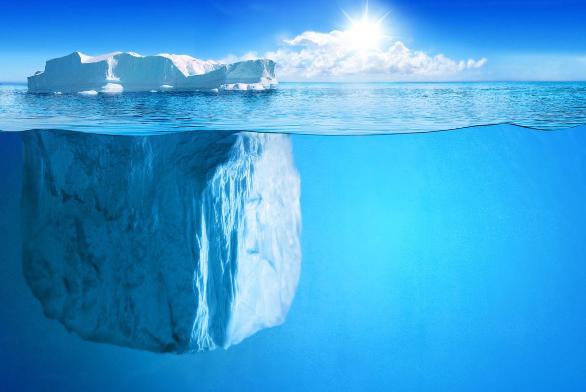
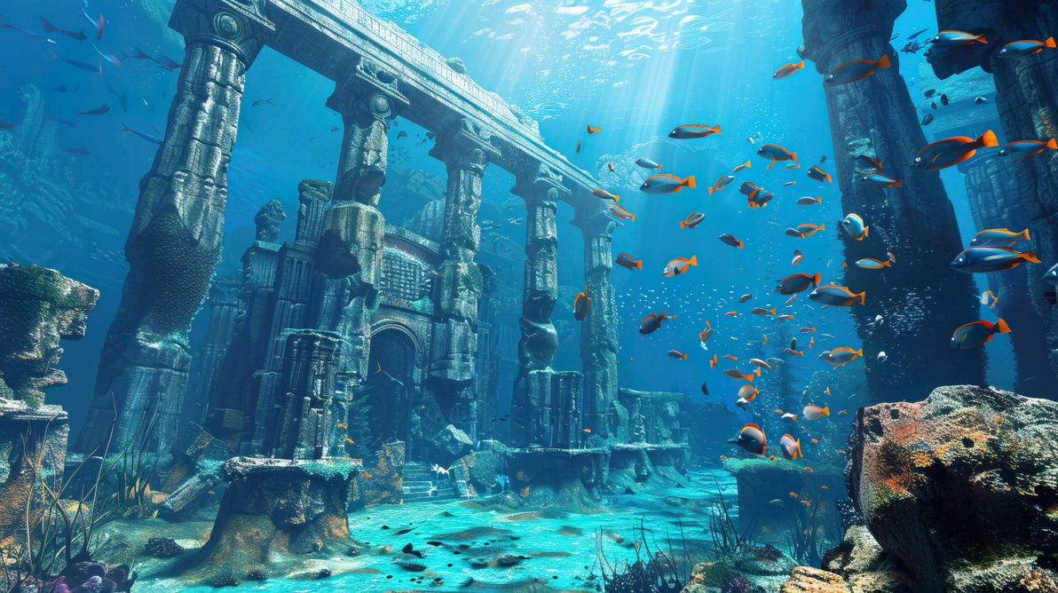

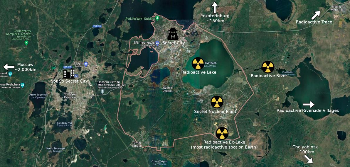


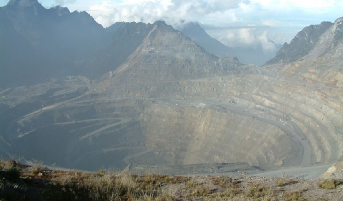
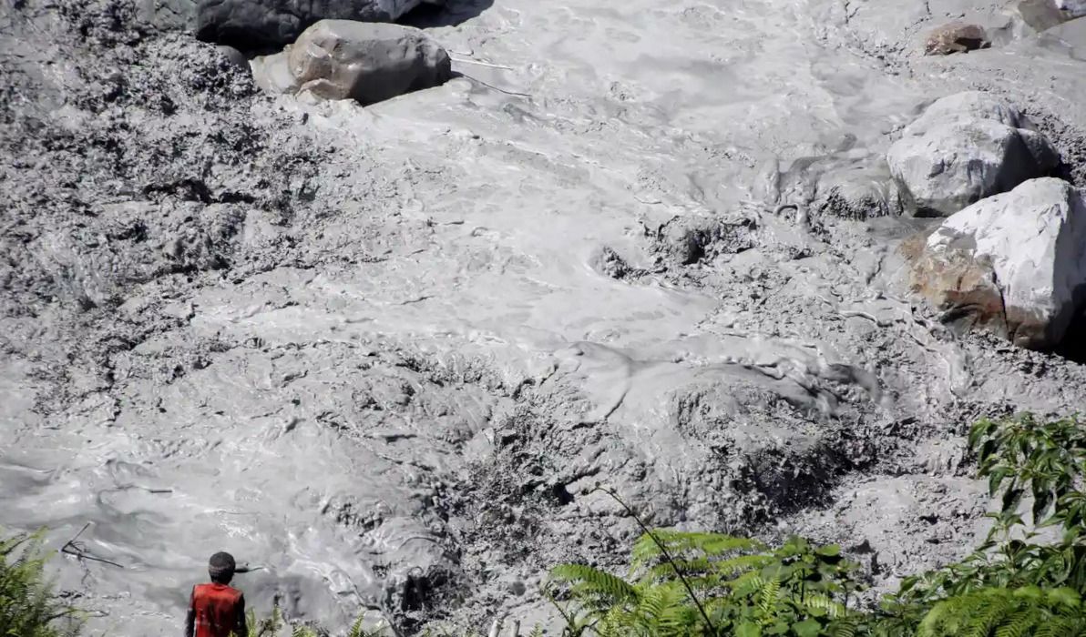

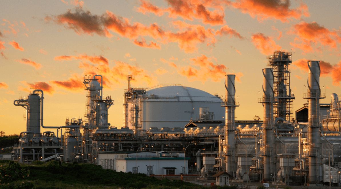
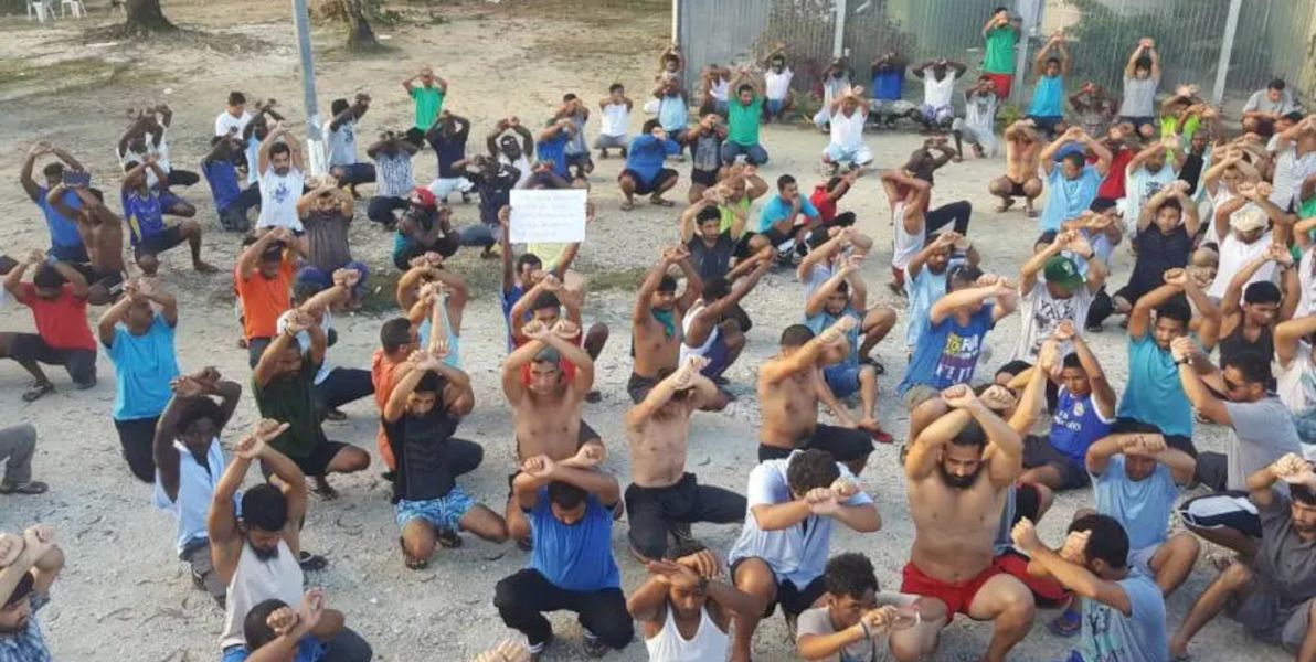


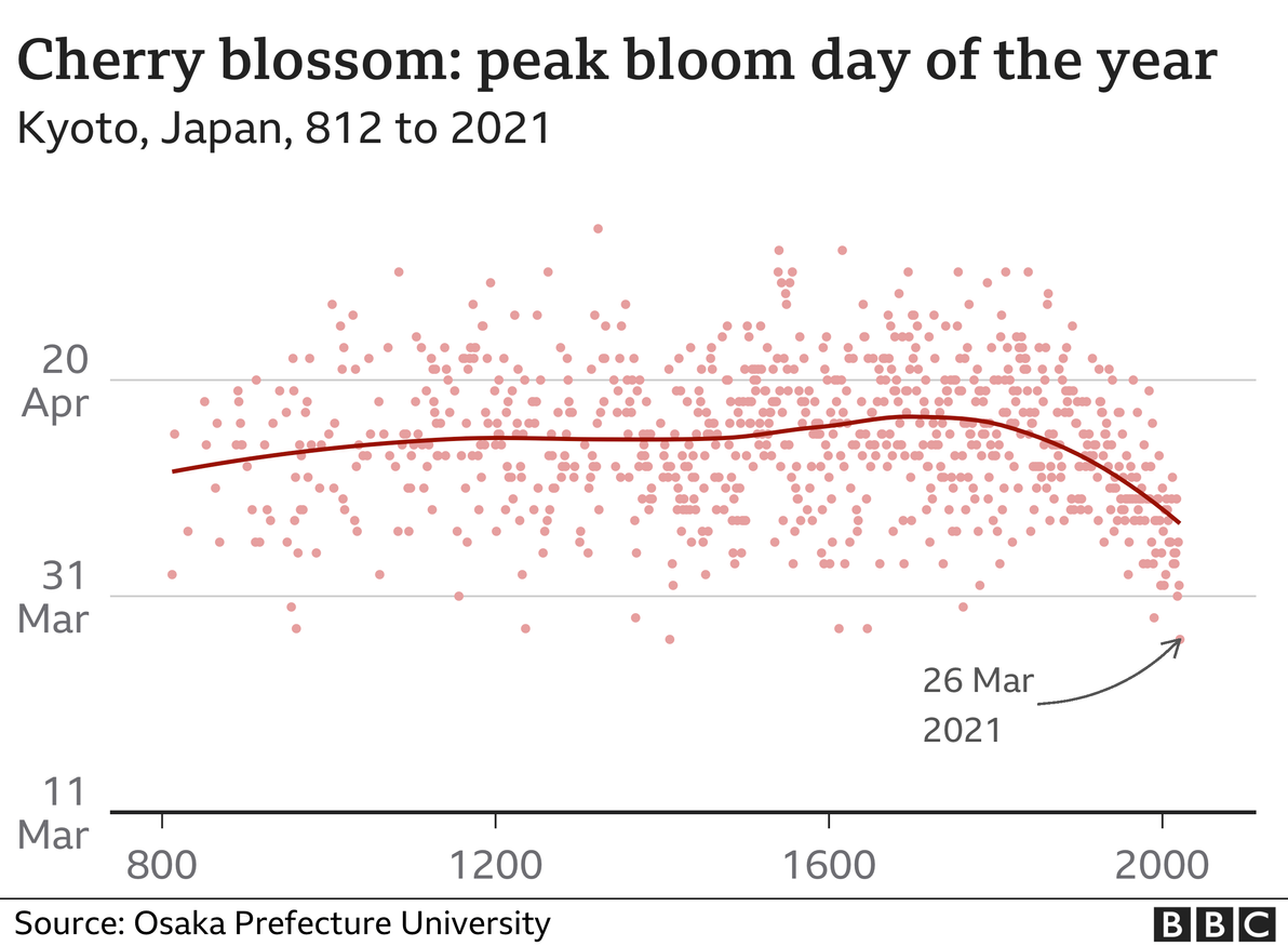


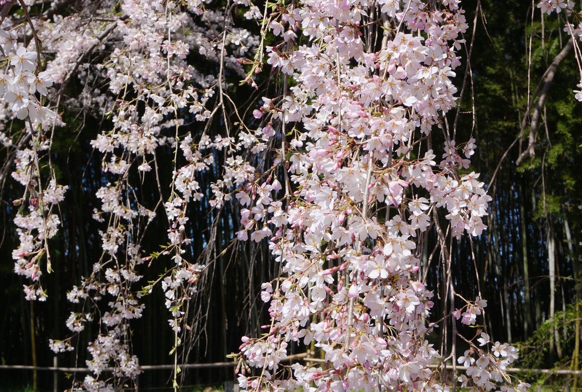
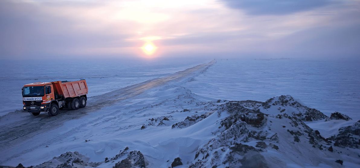
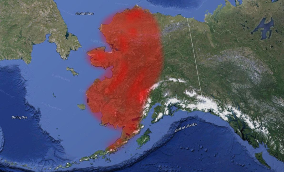
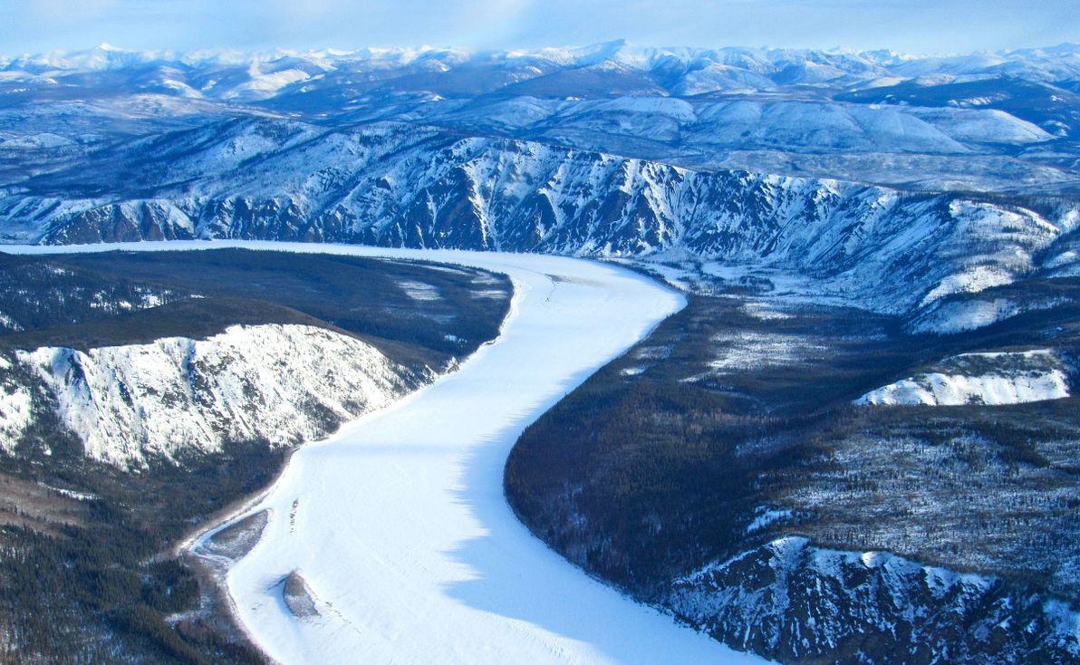
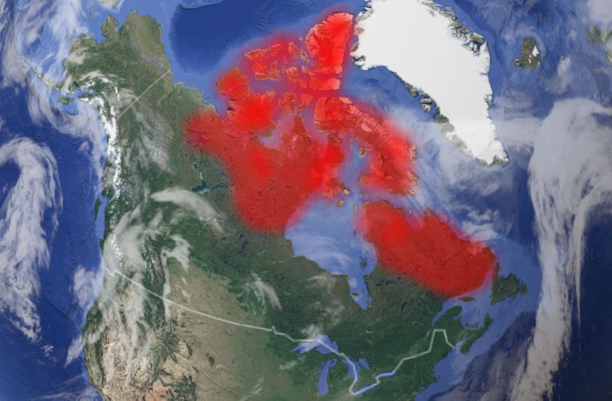
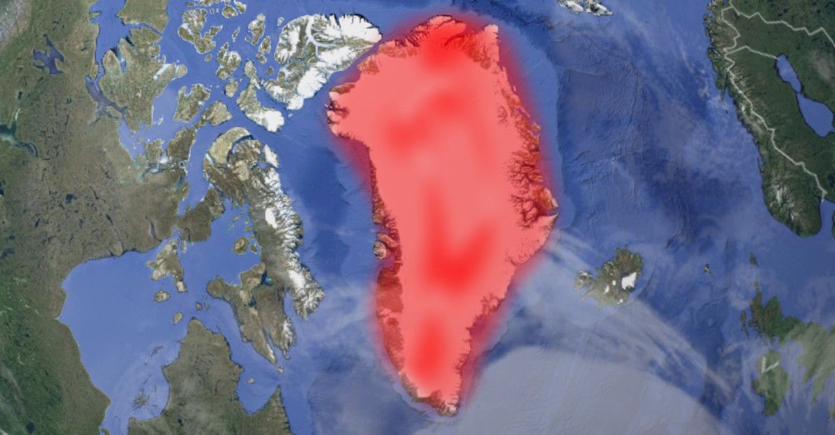
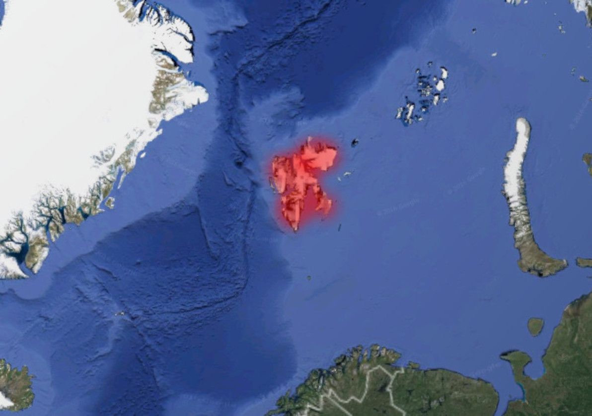
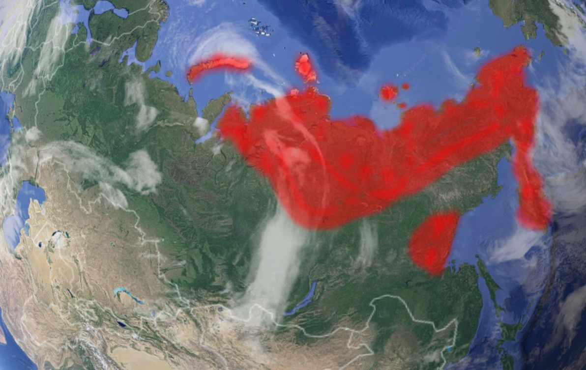
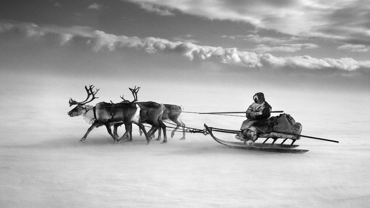
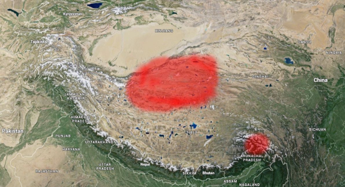
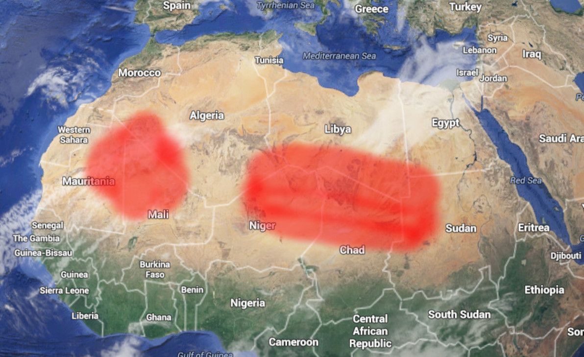
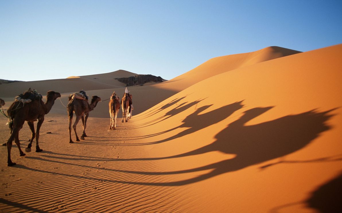
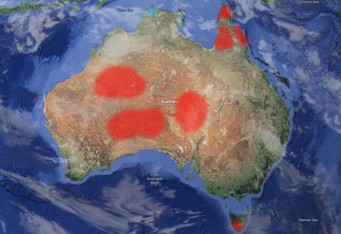
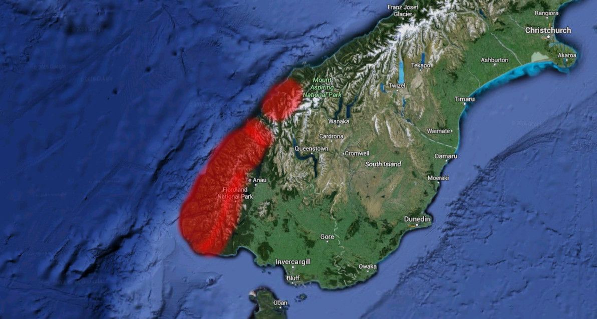
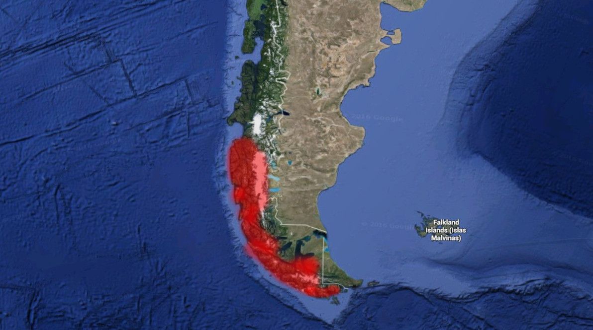
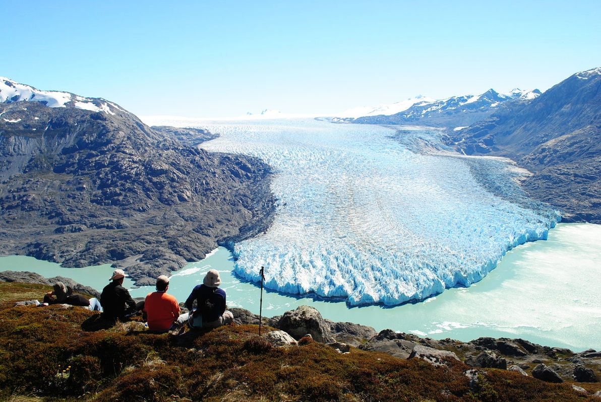
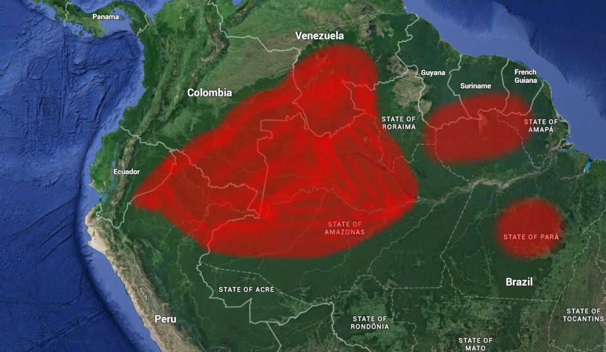
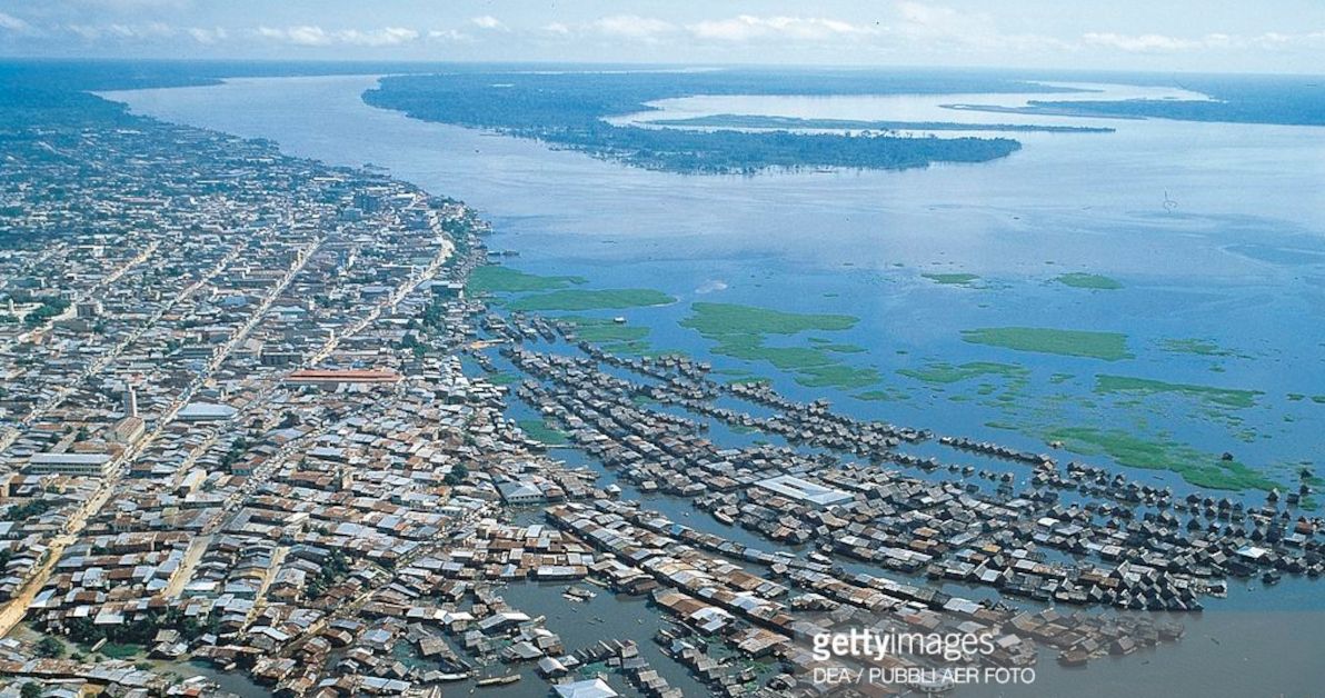
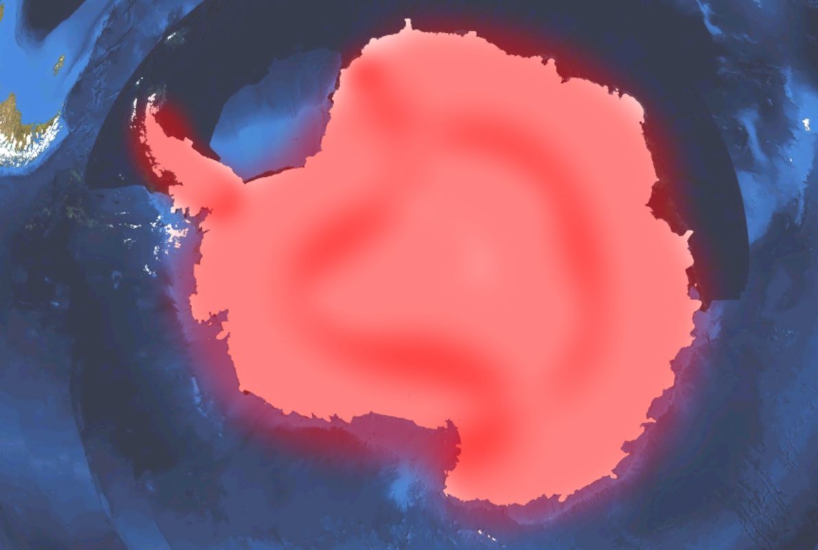
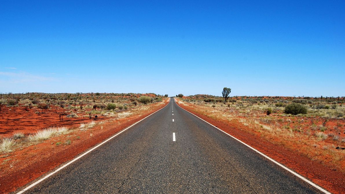
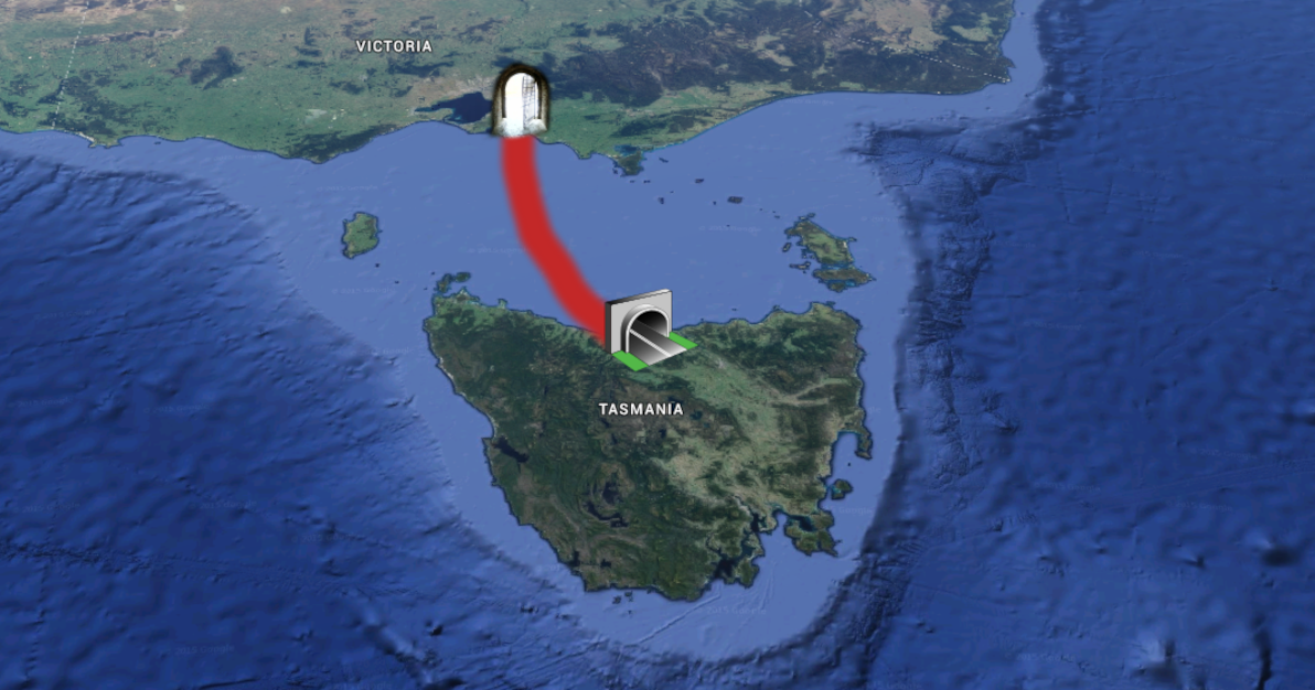
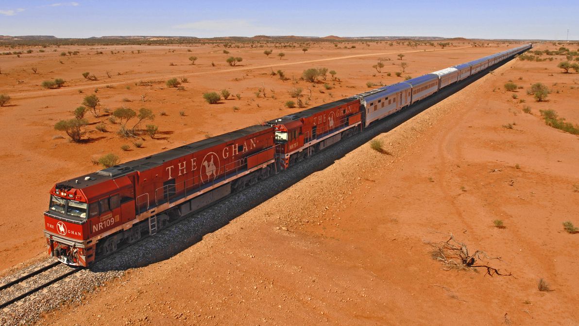
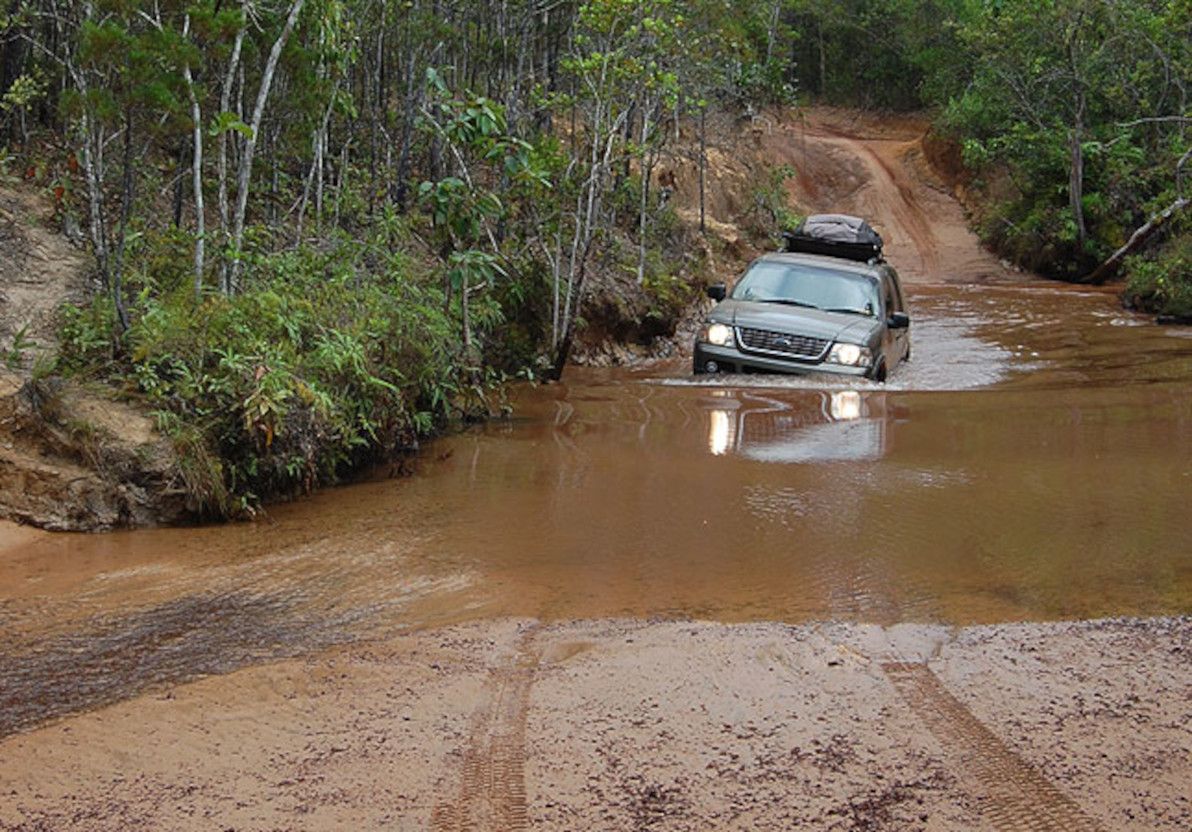
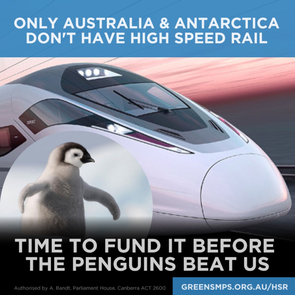
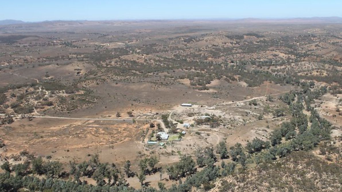
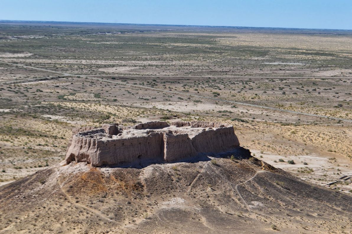
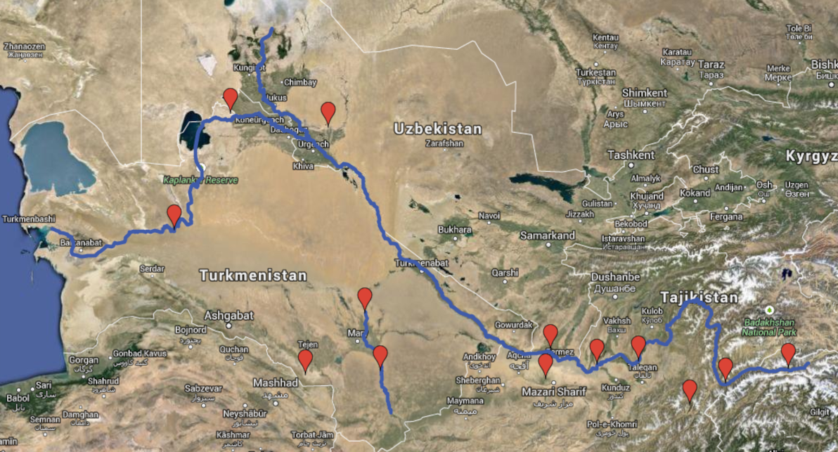
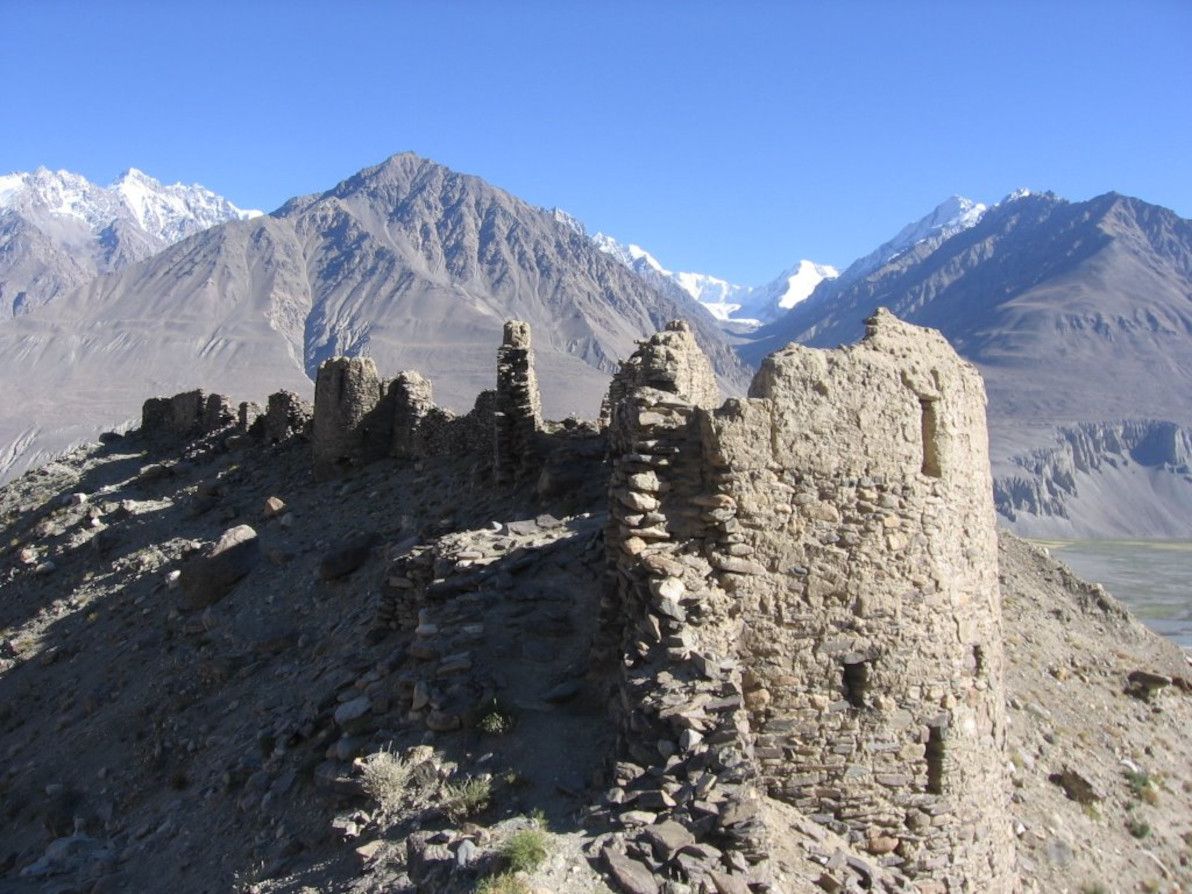
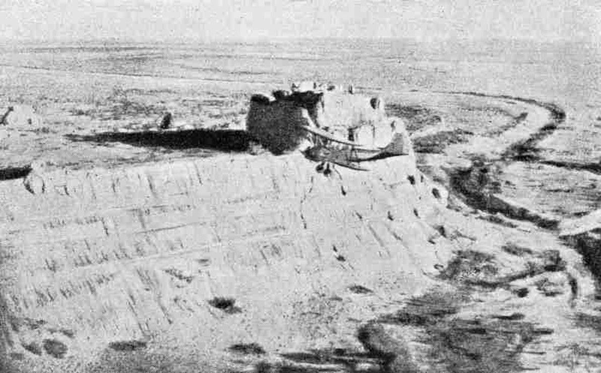
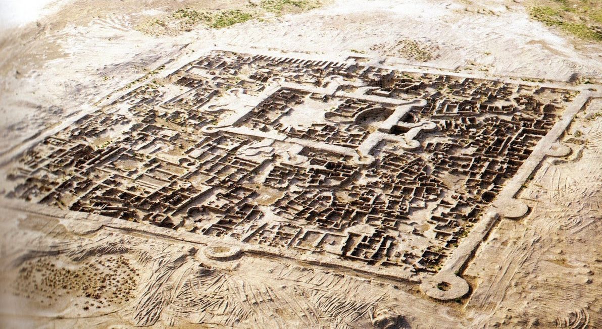
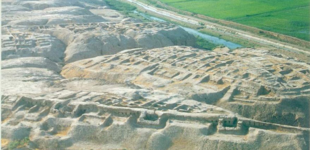
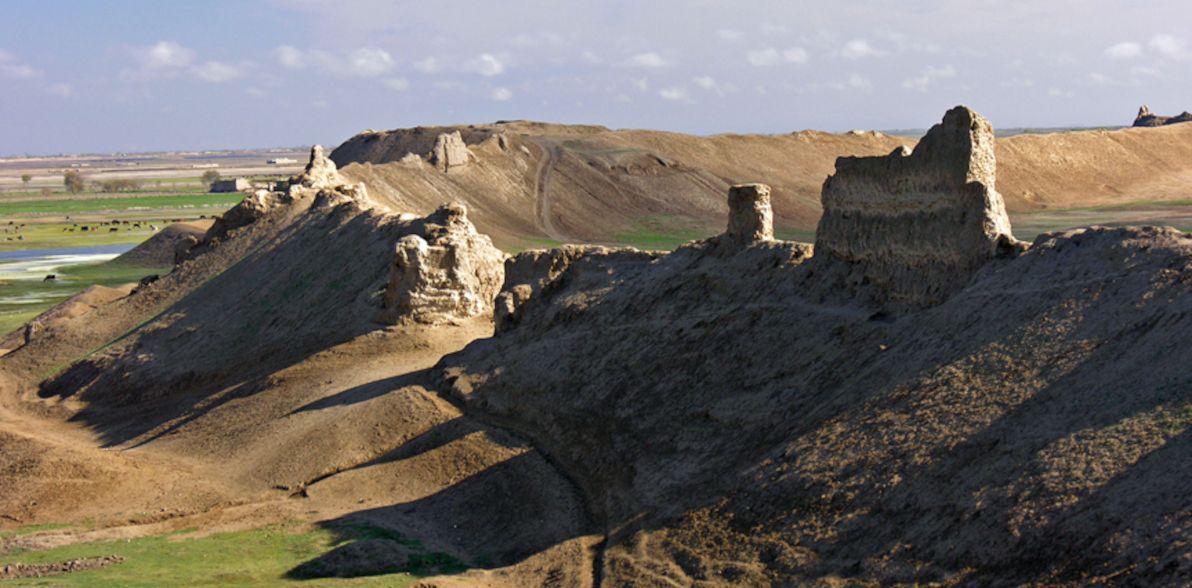
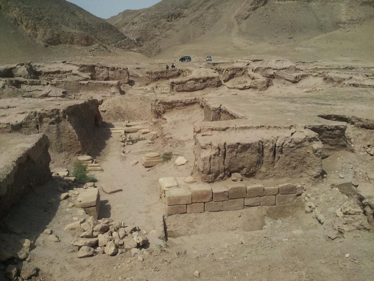
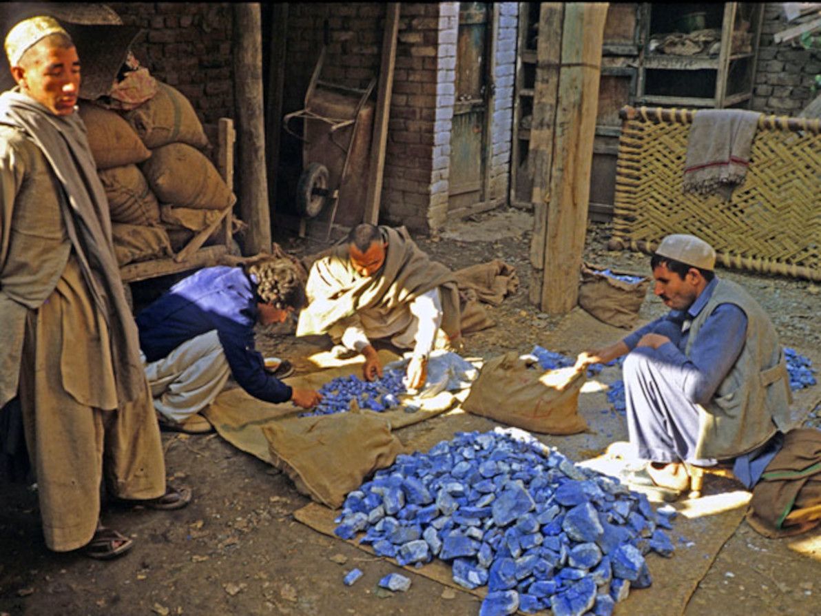
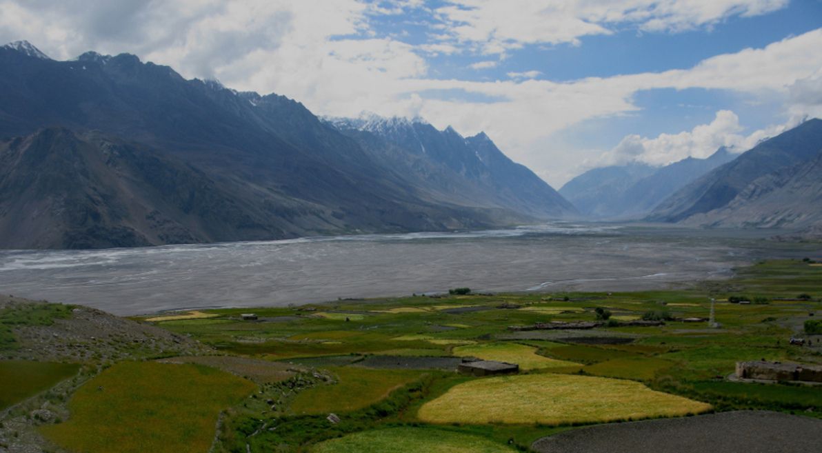
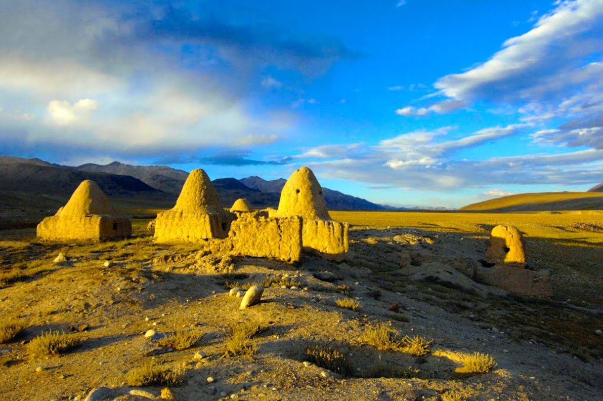
