aussie - GreenAshPoignant wit and hippie ramblings that are pertinent to aussie
https://greenash.net.au/thoughts/topics/aussie/
2023-10-09T00:00:00ZWhat (I think) the Voice is all about2023-10-09T00:00:00Z2023-10-09T00:00:00ZJazahttps://greenash.net.au/thoughts/2023/10/what-(i-think)-the-voice-is-all-about/
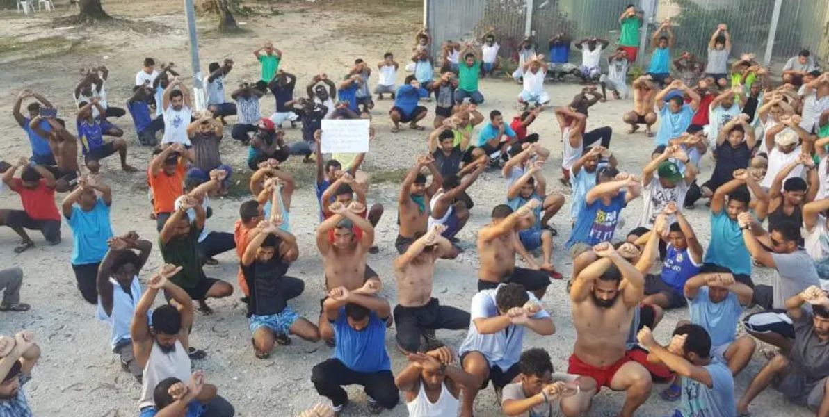
A few weeks ago, I had my first and only conversation with an ardent "No" campaigner for the upcoming Australian referendum on the Voice to Parliament. (I guess we really do all live in our own little echo chambers, because all my close friends and family are in the "Yes" camp just like me, and I was genuinely surprised and caught off guard to have bumped into a No guy, especially smack-bang in my home territory of affluent upper-middle-class North Shore Sydney.) When I asked why he'll be voting No, he replied: "Because I'm not racist". Which struck me, ironically, as one of the more racist remarks I've heard in my entire life.
Now that's what I call getting your voice heard. Image source: Fandom
I seldom write purely political pieces. I'm averse to walking into the ring and picking a fight with anyone. And honestly I find not-particularly-political writing on other topics (such as history and tech) to be more fun. Nor do I consider myself to be all that passionate about indigenous affairs – at least, not compared with other progressive causes such as the environment or refugees (maybe because I'm a racist privileged white guy myself!). However, with only five days to go until Australia votes (and with the forecast for said vote looking quite dismal), I thought I'd share my two cents on what, in my humble opinion, the Voice is all about.
I don't know about my fellow Yes advocates, but – call me cynical if you will – personally I have zero expectations of the plight of indigenous Australians actually improving, should the Voice be established. This is not about closing the gap. There are massive issues affecting Aborigines and Torres Strait Islanders, those issues have festered for a long time, and there's no silver bullet – no establishing of yet another advisory body, no throwing around of yet more money – that will magically or instantly change that. I hope that the Voice does make an inkling of a difference on the ground, but I'd say it'll be an inkling at best.
So then, what is this referendum about? It's about recognising indigenous Australians in the Constitution for the first time ever! (First-ever not racist mention, at least.) It's about adding something to the Constitution that's more than a purely symbolic gesture. It's about doing what indigenous Australians have asked for (yes, read the facts, they have asked for it!). It's about not having yet another decade or three of absolutely no progress being made towards reconciliation. And it's about Australia not being an embarassment to the world (in yet another way).
I'm not going to bother to regurgitate all the assertions of the Yes campaign, nor to try to refute all the vitriol of the No campaign, in this here humble piece (including, among the countless other bits of misinformation, the ridiculous claim that "the Voice is racist"). I just have this simple argument to put to y'all.
A vote for No is a vote for nothing. The Voice is something. It's not something perfect, but it's something, and it's an appropriate something for Australia in 2023, and it's better than nothing. And rather than being afraid of that modest little something (and expressing your fear by way of hostility), the only thing you should actually be afraid of – sure as hell the only thing I'm afraid of – is the shame and disgrace of doing more nothing.
I have also made the casual observation, over the last three years, that Morrison makes few appearances on Aunty in general, compared with the commercial alternatives, particularly Sky News (which I personally have never watched directly, and have no plans to, but I've seen plenty of clips of Morrison on Sky repeated on the ABC and elsewhere).
This led me to do some research, to find out: how often has Morrison taken part in ABC interviews, during his tenure so far as Prime Minister, compared with his predecessors? I compiled my findings, and this is what they show:
Morrison's ABC interview frequency compared to his forebears
It's official: Morrison has, on average, taken part in fewer ABC TV and Radio interviews, than any other Prime Minister in recent Australian history.
I hope you find my humble dataset useful. Apart from illustrating Morrison's disdain for the ABC, there are also tonnes of other interesting analyses that could be performed on the data, and tonnes of other conclusions that could be drawn from it.
My findings are hardly surprising, considering Morrison's flagrant preference for sensationalism, spin, and the far-right fringe. I leave it as an exercise to the reader, to draw from my dataset what conclusions you will, regarding the fate of the already Coalition-scarred ABC, should Morrison win a second term.
]]>
Is Australia supporting atrocities in West Papua?2022-04-30T00:00:00Z2022-04-30T00:00:00ZJazahttps://greenash.net.au/thoughts/2022/04/is-australia-supporting-atrocities-in-west-papua/
A wee lil' fact check style analysis of The Juice Media's 2018 video Honest Government Ad: Visit West Papua. Not that I don't love TJM's videos (that would be un-Australien!). Just that a number of the claims in that particular piece took me by surprise.
Note: in keeping with what appears to be the standard in English-language media, for the rest of this article I'll be referring to the whole western half of the island of New Guinea – that is, to both of the present-day Indonesian provinces of Papua and West Papua – collectively as "West Papua".
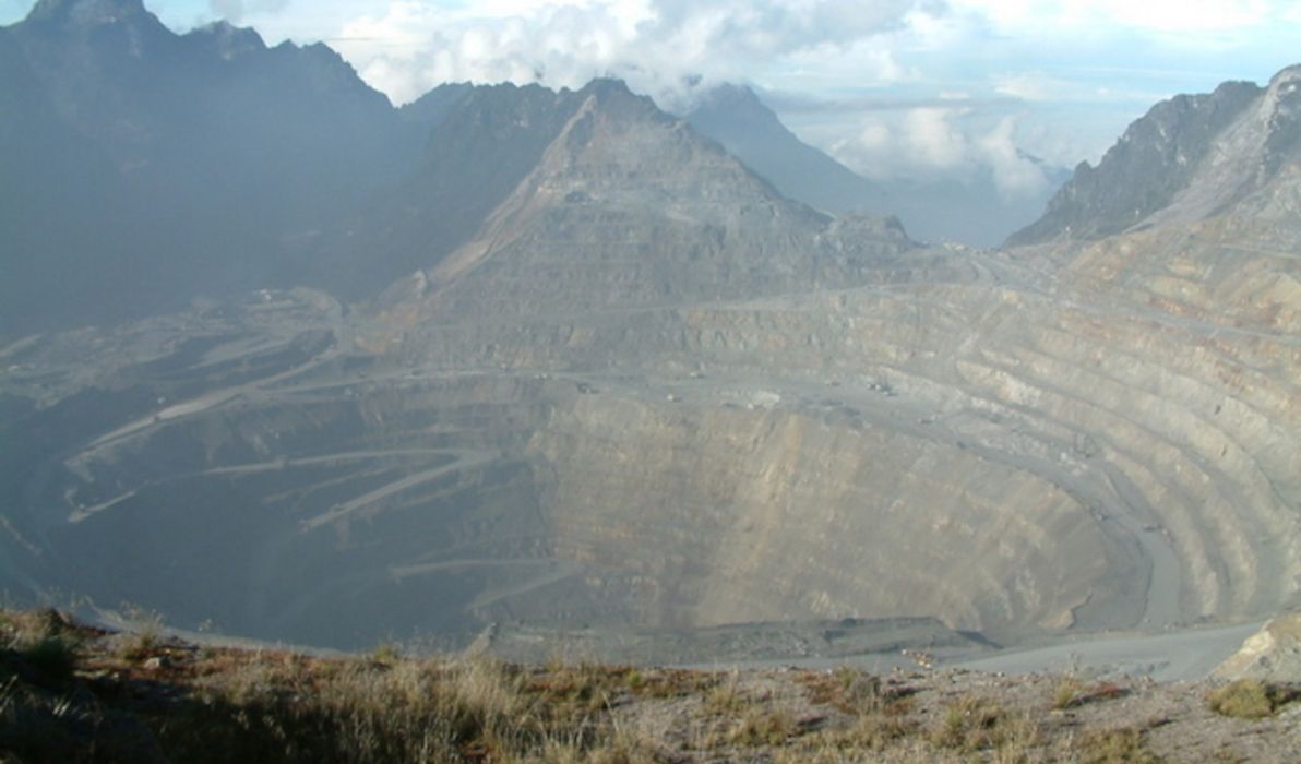
Grasberg mine
Let's start with one of the video's least controversial claims – one that's about a simple objective fact, and one that has nothing to do with Australia:
[Grasberg mine] … the biggest copper and gold mine in the world
Close enough
I had never heard of the Grasberg mine before. Just like I had never heard much in general about West Papua before – even though it's only about 200km from (the near-uninhabited northern tip of) Australia. Which I guess is due to the scant media coverage afforded to what has become a forgotten region.
But. Are a significant number of Australian-trained Indonesian government personnel deployed in West Papua, compared with elsewhere in the vastness of Indonesia? We don't know (although it seems unlikely). Does Australia train Indonesian personnel in a manner that encourages violence towards civilians? No idea (but I should hope not). And does Australia have any control over what the Indonesian government does with the resources provided to it? Not really.
I agree that, considering the Indonesian military's track record of human rights abuses, it would probably be a good idea for Australia to stop resourcing it. The risk of Australia indirectly facilitating human rights abuses, in my opinion, outweighs the diplomatic and geopolitical benefits of neighbourly cooperation.
Nevertheless: Australia (as far as we know) has no boots on the ground in West Papua; (I have to reluctantly say that) Australia is not responsible for how the Indonesian military utilises the training and equipment that it has received; and there's insufficient evidence to link Australia's support of the Indonesian military to date, with goings-on in West Papua.
I declare this claim to be exaggerated.
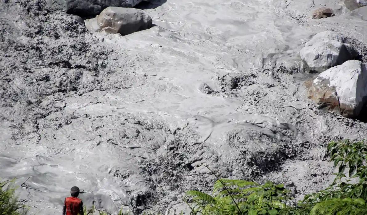
Corporate plunder
so that our other mates [Rio Tinto, LG, BP, Freeport-McMoRan] can come in and start makin' the ching ching
Freeport-McMoRan has, of course, been Grasberg's principal owner and operator for most of the mine's history, as well as the principal entity that has been raking in on the mine's insane profits. The company has some business ventures in Australia, although its ties with the Australian economy, and therefore with the Australian government, appear to be quite modest.
BP is the main owner of the Tangguh gas field, which is probably the second-largest and second-most-lucrative (and second-most-polluting!) industrial enterprise in West Papua. BP is of course a British company, but it has a significant presence in Australia. LG appears to also be involved in Tangguh. LG is a Korean company, and it has modest ties to the Australian economy.
The Tangguh LNG site in West Papua Image source: KBR
So, all of these companies could be considered "mates" of the Australian government (some more so than others). And all of them are, or until recently were, "makin' the ching ching" in West Papua.
I declare this claim to be very close to the truth.
Stopping independence
Remember when two Papuans [Clemens Runaweri and Willem Zonggonau] tried to flee to the UN to expose this bulls***? We [Australia] prevented them from ever getting there, by detaining them on Manus Island
Checks out
Well, no, I don't remember it, because – apart from the fact that it happened long before I was born – it's an incident that has scarcely ever been covered by the media (much like the lack of media coverage of West Papua in general). Nevertheless, it did happen, and it is documented:
In May 1969, two young West Papuan leaders named Clemens Runaweri and Willem Zonggonau attempted to board a plane in Port Moresby for New York so that they could sound the alarm at UN headquarters. At the request of the Indonesian government, Australian authorities detained them on Manus Island when their plane stopped to refuel, ensuring that West Papuan voices were silenced.
After being briefly detained, the two men lived the rest of their lives in exile in Papua New Guinea. Zonggonau died in Sydney in 2006, where he and Runaweri were visiting, still campaigning to free their homeland until the end. Runaweri died in Port Moresby in 2011.
Celebrating half a century of locking up innocent people on remote Pacific islands Image source: The New York Times
I declare this claim to be 100% correct.
Training hitmen
We [Australia] helped train [at the Indonesia-Australia Defence Alumni Association (IKAHAN)] and arm those heroes [the hitmen who assassinated the Papuans' leader Theys Eluay in 2001]
I don't know why IKAHAN was mentioned together with the 2001 murder of Eluay, because it wasn't founded until 2011, so one couldn't possibly have anything to do with the other. It's possible that Eluay's killers received Australian-backed training elsewhere, but not there. Similarly, it's possible that training undertaken at IKAHAN has contributed to other shameful incidents in West Papua, but not that one. Mentioning IKAHAN does nothing except conflate the facts.
In any case, I repeat, (I have to reluctantly say that) Australia is not responsible for how the Indonesian military utilises the training and equipment that it has received; and there's insufficient evidence to link Australia's support of the Indonesian military to date, with goings-on in West Papua.
I declare this claim to be exaggerated.
Shipments from Cairns
which [Grasberg mine] is serviced by massive shipments from Cairns. Cairns! The Aussie town supplying West Papua's Death Star with all its operational needs
"Citations needed"
This claim really came at me out of left field. So much so, that it was the main impetus for me penning this article as a fact check. Can it be true? Is the laid-back tourist town of Cairns really the source of regular shipments of supplies, to the industrial hellhole that is Grasberg?
I honestly don't know how TJM got their hands on this bit of intel, because there's barely any mention of it in any media, mainstream or otherwise. Clearly, this was an arrangement that all involved parties made a concerted effort to keep under the radar for many years.
In any case, yes, it appears to be true. Or, at least, it was true at the time that the video was published, and it had been true for about 45 years, up until that time. Then, in 2019, the shipping, and Freeport-McMoRan's presence in town, apparently disappeared from Cairns, presumably replaced by alternative logistics based in Indonesia (and presumably due to the Indonesian government having negotiated to make itself the majority owner of Grasberg shortly before that).
It makes sense logistically. Cairns is one of the closest fully-equipped ports to Grasberg, only slightly further away than Darwin. Much closer than Jakarta or any of the other big ports in the Indonesian heartland. And I can imagine that, for various economic and political reasons, it may well have been easier to supply Grasberg primarily from Australia rather than from elsewhere within Indonesia.
I would consider that this claim fully checks out, if I could find more sources to corroborate it. However, there's virtually no word of it in any mainstream media; and the sources that do mention it are old and of uncertain reliability.
I declare this claim to be "citations needed".
Verdict
Australia is proud to continue its fine tradition of complicity in West Papua
Exaggerated
In conclusion, I declare that the video "Honest Government Ad: Visit West Papua", on the whole, checks out. In particular, its allegation of the Australian government being economically complicit in the large-scale corporate plunder and environmental devastation of West Papua – by way of it having significant ties with many of the multinational companies operating there – is spot-on.
But. Regarding the Australian government being militarily complicit in human rights abuses in West Papua, I consider that to be a stronger allegation than is warranted. Providing training and equipment to the Indonesian military, and then turning a blind eye to the Indonesian military's actions, is deplorable, to be sure. Australia being apathetic towards human rights abuses, would be a valid allegation.
To be "complicit", in my opinion, there would have to be Australian personnel on the ground, actively committing abuses alongside Indonesian personnel, or actively aiding and abetting such abuses.
Don't get me wrong, I most certainly am not defending Australia as the patron saint of West Papua, and I'm not absolving Australia of any and all responsibility towards human rights abuses in West Papua. I'm just saying that TJM got a bit carried away with the level of blame they apportioned to Australia on that front.
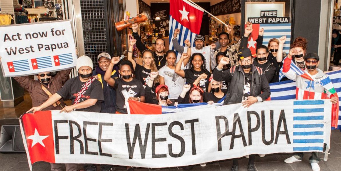
Protesting for West Papuan independence Image source: new mandala
Also, bear in mind that the only reason I'm "going soft" on Australia here, is due to a lack of evidence of Australia's direct involvement militarily in West Papua. It's quite possible that there is indeed a more direct involvement, but that all evidence of it has been suppressed, both by Indonesia and by Australia.
And hey, I'm trying to play devil's advocate in this here article, which means that I'm giving TJM more of a grilling than I otherwise would, were I to simply preach my unadulterated opinion.
I'd like to wholeheartedly thank TJM for producing this video (along with all their other videos). Despite me giving them a hard time here, the video is – as TJM themselves tongue-in-cheek say – "surprisingly honest!". It educated me immensely, and I hope it educates many more folks just as immensely, as to the lamentable goings-on, right on Australia's doorstep, about which we Aussies (not to mention the rest of the world) hear unacceptably little.
The Australian government is, at the very least, one of those responsible for maintaining the status quo in West Papua. And "business as usual" over there clearly includes a generous dollop of atrocities.
]]>
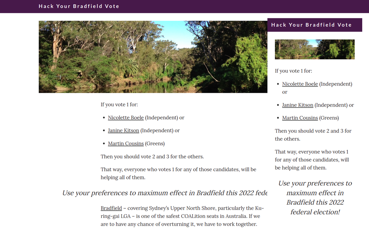
Introducing: Hack Your Bradfield Vote2022-04-10T00:00:00Z2022-04-10T00:00:00ZJazahttps://greenash.net.au/thoughts/2022/04/introducing-hack-your-bradfield-vote/
I built a tiny site, that I humbly hope makes a tiny difference in my home electorate of Bradfield, this 2022 federal election. Check out Hack Your Bradfield Vote.
How "Hack Your Bradfield Vote" looks on desktop and mobile
I'm not overly optimistic, here in what is one of the safest Liberal seats in Australia. But you never know, this may finally be the year when the winds of change rustle the verdant treescape of Sydney's leafy North Shore.
]]>
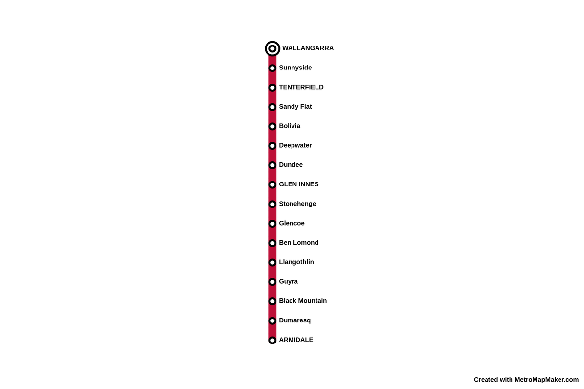
The lost Armidale to Wallangarra railway2021-11-15T00:00:00Z2021-11-15T00:00:00ZJazahttps://greenash.net.au/thoughts/2021/11/the-lost-armidale-to-wallangarra-railway/
Running more-or-less alongside the most remote section of the New England Highway, through the Northern Tablelands region of NSW, can be found the remnants of a once-proud train line. The Great Northern Railway, as it was known in its heyday, provided the only railway service linking Sydney and Brisbane, between 1889 and 1930. Regular passenger services continued until 1972, and the line has been completely closed since 1988.
Metro map style illustration of the old Armidale to Wallangarra passenger service Thanks to:Metro Map Maker
Although I once drove through most of the Northern Tablelands, I wasn't aware of this railway, nor of its sad recent history, at the time. I just stumbled across it a few days ago, browsing maps online. I decided to pen this here wee thought, mainly because I was surprised at how scant information there is about the old line and its stations.
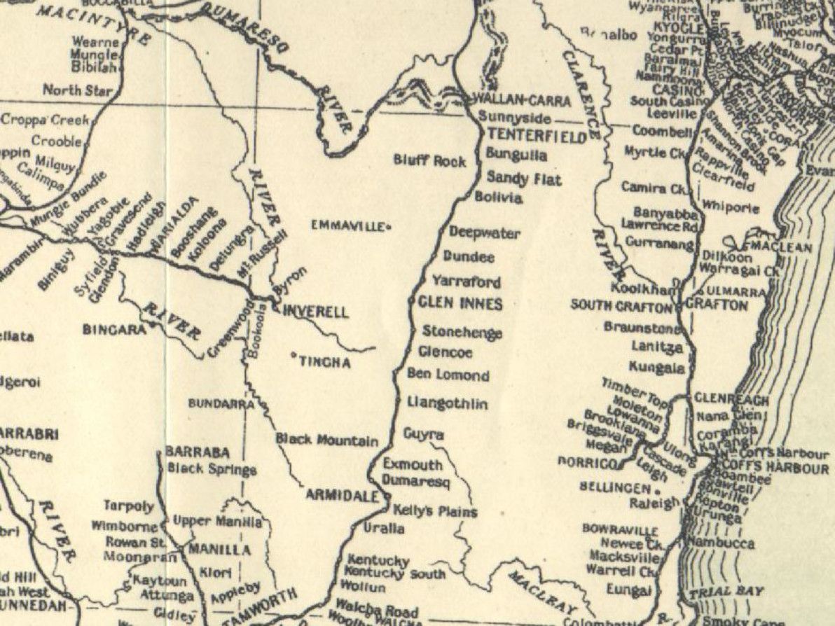
Great Northern Railway as shown in the 1933 official NSW government map Image source:NSWrail.net
You may notice that some of the stops shown in the 1933 map, are missing from my metro map style illustration. I have omitted all of the stops that are listed as something other than "station" in this long list of facilities on the Main North Line. As far as I can tell, all of the stops listed as "unknown" or "loop", were at best very frugal platform sidings that barely qualified as stations, and their locations were never really populated towns (even going by the generous Aussie bush definition of "populated town", that is, "two people, three pubs").
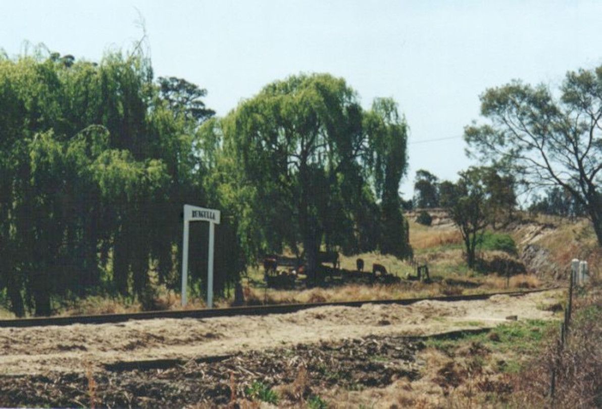
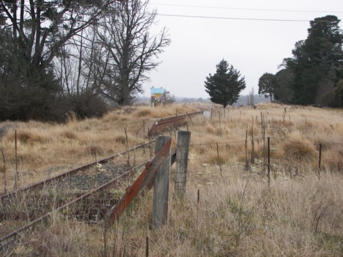
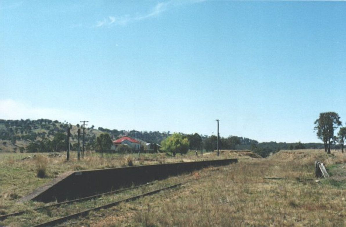
All that remains of Bungulla, just south of Tenterfield Image source:NSWrail.net
Although some people haven't forgotten about it – particularly many of the locals – the railway is clearly disappearing from the collective consciousness, just as it's slowly but surely eroding and rotting away out there in the New England countryside.
Stonehenge station, just south of Glen Innes, has seen better days Image source:NSWrail.net
Some of the stations along the old line were (apparently) once decent-sized towns, but it's not just the railway that's now long gone, it's the towns too! For example, Bolivia (the place that first caught my eye on the map, and that got me started researching all this – who would have imagined that there's a Bolivia in NSW?!), which legend has it was a bustling place at the turn of the 20th century, is nothing but a handful of derelict buildings now.
Bolivia ain't even a one-horse town no more Image source:NSWrail.net
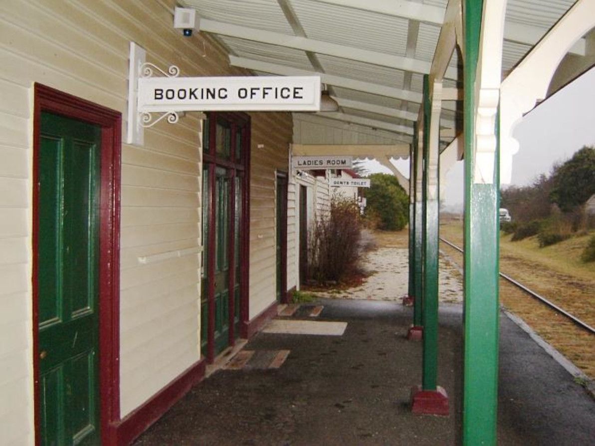
Other stations – and other towns, for that matter – along the old railway, appear to be faring better. In particular, Black Mountain station is being most admirably maintained by a local group, and Black Mountain village is also alive and well.
The main platform at Black Mountain station Image source:NSWrail.net
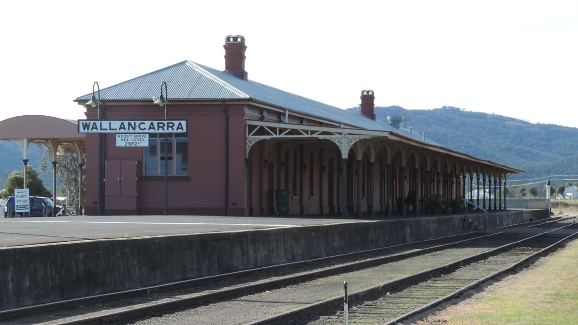
These days, on the NSW side, the Main North Line remains open up to Armidale, and a passenger train service continues to operate daily between Sydney and Armidale. On the Queensland side, the Southern line between Toowoomba and Wallangarra is officially still open to this day, and is maintained by Queensland Rail, however my understanding is that there's only a train actually on the tracks, all the way down to Wallangarra, once in a blue moon. On the Main line, a passenger service currently operates twice a week between Brisbane and Toowoomba (it's the Westlander service, which continues from Toowoomba all the way to Charleville).
The unique Wallangarra station, with its standard-guage NSW side, and its narrow-guage Qld side Image source:Wikimedia Commons
The chances of the Armidale to Wallangarra railway ever re-opening are – to use the historically appropriate Aussie vernacular – Buckley's and none. The main idea that the local councils have been bandying about for the past few years, has been to convert the abandoned line into a rail trail for cycling. It looks like that plan is on the verge of going ahead, even though a number of local citizens are vehemently opposed to it. Personally, I don't think a rail trail is such a bad idea: the route will at least get more use, and will receive more maintenance, than it has for the past several decades; and it would bring a welcome trickle of tourists and adventurers to the region.
The Armidale to Wallangarra railway isn't completely lost nor forgotten. But it's a woeful echo of its long-gone glory days (it isn't even properly marked on Google Maps – although it's pretty well-marked on OpenStreetMap, and it's still quite visible on Google Maps satellite imagery). And, regretfully, it's one of countless many derelict train lines scattered across NSW: others include the Bombala line (which I've seen numerous times, running adjacent to the Monaro Highway, while driving down to Cooma from Sydney), the Nyngan to Bourke line, and the Murwillumbah line.
May this article, if nothing else, at least help to document what exactly the stations were on the old line, and how they're looking in this day and age. And, whether it's a rail trail or just an old relic by the time I get around to it, I'll have to head up there and see the old line for myself. I don't know exactly what future lies ahead for the Armidale to Wallangarra railway, but I sincerely hope that, both literally and figuratively, it doesn't simply fade into oblivion.
]]>
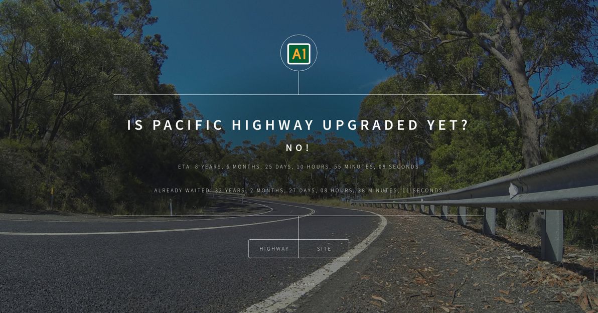
Introducing: Is Pacific Highway Upgraded Yet?2021-06-08T00:00:00Z2021-06-08T00:00:00ZJazahttps://greenash.net.au/thoughts/2021/06/introducing-is-pacific-highway-upgraded-yet/
Check out this fun little site that I just built: Is Pacific Highway Upgraded Yet?Spoiler alert: no it's not!
I got thinking about this, in light of the government's announcement at the end of 2020 that the Pacific Highway upgrade is finished. I was like, hang on, no it's not! How about a web site to tell people how long we've already been waiting for this (spoiler alert: ages!), and how much longer we'll probably be waiting?
Complete with a countdown timer, which is currently set to 1 Jan 2030, a date that I arbitrarily and fairly optimistically picked as the target completion date of the Hexham bypass (but that project is still in the planning stage, no construction dates have currently been announced).
Fellow Australians, enjoy!
]]>
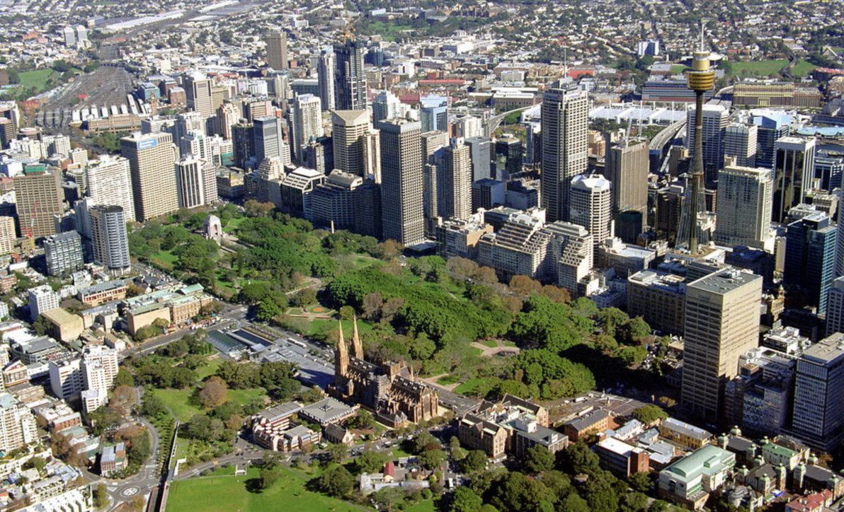
Where is the official centre of Sydney?2016-03-28T00:00:00Z2016-03-28T00:00:00ZJazahttps://greenash.net.au/thoughts/2016/03/where-is-the-official-centre-of-sydney/
There are several different ways of commonly identifying the "official centre point" of a city. However, there's little international consensus as to the definition of such a point, and in many countries and cities the definition is quite vague.
Most reliable and most common, is to declare a Kilometre Zero marker as a city's (and often a region's or even a country's) official centre. Also popular is the use of a central post office for this purpose. Other traditional centre points include a city's cathedral, its main railway station, its main clock tower (which may be atop the post office / cathedral / railway station), its tallest building, its central square, its seat of government, its main park, its most famous tourist landmark, or the historical spot at which the city was founded.
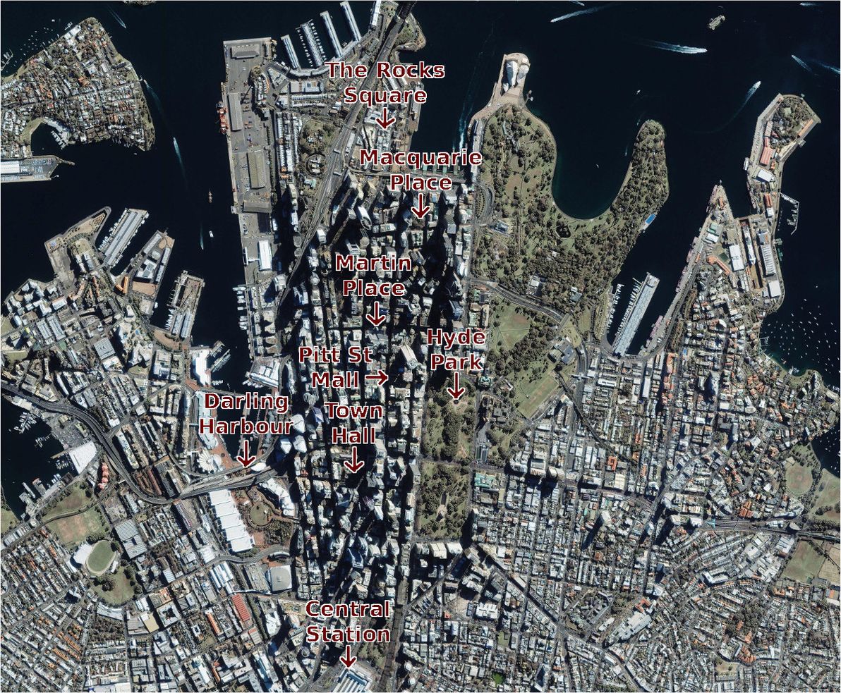
Satellite photo of Sydney CBD, annotated with locations of "official centre" candidates. Image source:Satellite Imaging Corp.
My home town of Sydney, Australia, is one of a number of cities worldwide that boasts most of the above landmarks, but all in different locations, and without any mandated rule as to which of them constitutes the official city centre. So, where exactly in Sydney does X mark the spot?
Martin Place
I'll start with the spot that most people – Sydneysiders and visitors alike – commonly consider to be Sydney's central plaza these days: Martin Place. Despite this high esteem that it enjoys, in typical unplanned Sydney fashion, Martin Place was actually never intended to even be a large plaza, let alone the city's focal point.
Martin Place from the western end, as it looks today. Image source:Wikimedia Commons.
The original "Martin Place" (for much of the 1800s) was a small laneway called Moore St between George and Pitt streets, similar to nearby Angel Place (which remains a laneway to this day). In 1892, just after the completion of the grandiose GPO Building at its doorstep, Martin Place was widened and was given its present name. It wasn't extended to Macquarie St, nor made pedestrian-only, until 1980 (just after the completion of the underground Martin Place Station).
The chief justification for Martin Place being a candidate on this list, is that it's the home of Sydney's central post office. The GPO building also has an impressive clock tower sitting atop it. In addition, Martin Place is home to the Reserve Bank of Australia, and the NSW Parliament and the State Library of NSW are very close to its eastern end. It's also geographically smack-bang in the centre of the "business end" of Sydney's modern CBD, and it's culturally and socially acknowledged as the city's centre.
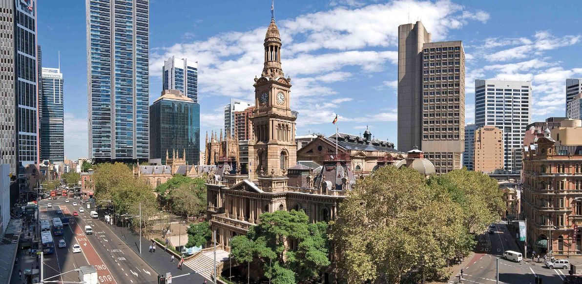
Town Hall
If you ask someone on the street in Sydney where the city's "central spot" is, and if he/she hesitates for a moment, chances are that said person is tossing up between Martin Place and Town Hall. When saying the name "Town Hall", you could be referring to the underground train station (one of Sydney's busiest), to the Town Hall building itself, to Town Hall Square, or (most likely) to all of the above. Scope aside, Town Hall is one of the top candidates for being called the centre of Sydney.
View of the Town Hall building, busy George and Druitt Streets, and St Andrews Cathedral. Image source:FM Magazine.
As with Martin Place, Town Hall was never planned to either resemble its current form, nor to be a centric location. Indeed, during the early colonial days, the site in question was on the outskirts of Sydney Town, and was originally a cemetery. The Town Hall building was opened in the 1890s.
In terms of qualifying as the potential centre of Sydney, Town Hall has a lot going for it. As its name suggests, it's home to the building which is the seat of local government for the City of Sydney (the building also has a clock tower). With its sprawling underground train station, with numerous bus stops in and adjacent to it, and with its location at the intersection of major thoroughfares George St and Park / Druitt St, Town Hall is – in practice – Sydney's most important transport hub. It's home to St Andrew's Cathedral, the head of the Anglican church in Sydney. And it's adjacent to the Queen Victoria Building, which – although it has no official role – is considered one of Sydney's most beautiful buildings.
Town Hall is also in an interesting position in terms of urban geography. It's one of the more southerly candidates for "official centre". To its north, where the historic heart of Sydney lies, big businesses and workers in suits dominate. While to its south lies the "other half" of Sydney's CBD: some white-collar business, but more entertainment, restaurants, sleaze, and shopping. It could be said that Town Hall is where these two halves of the city centre meet and mingle.
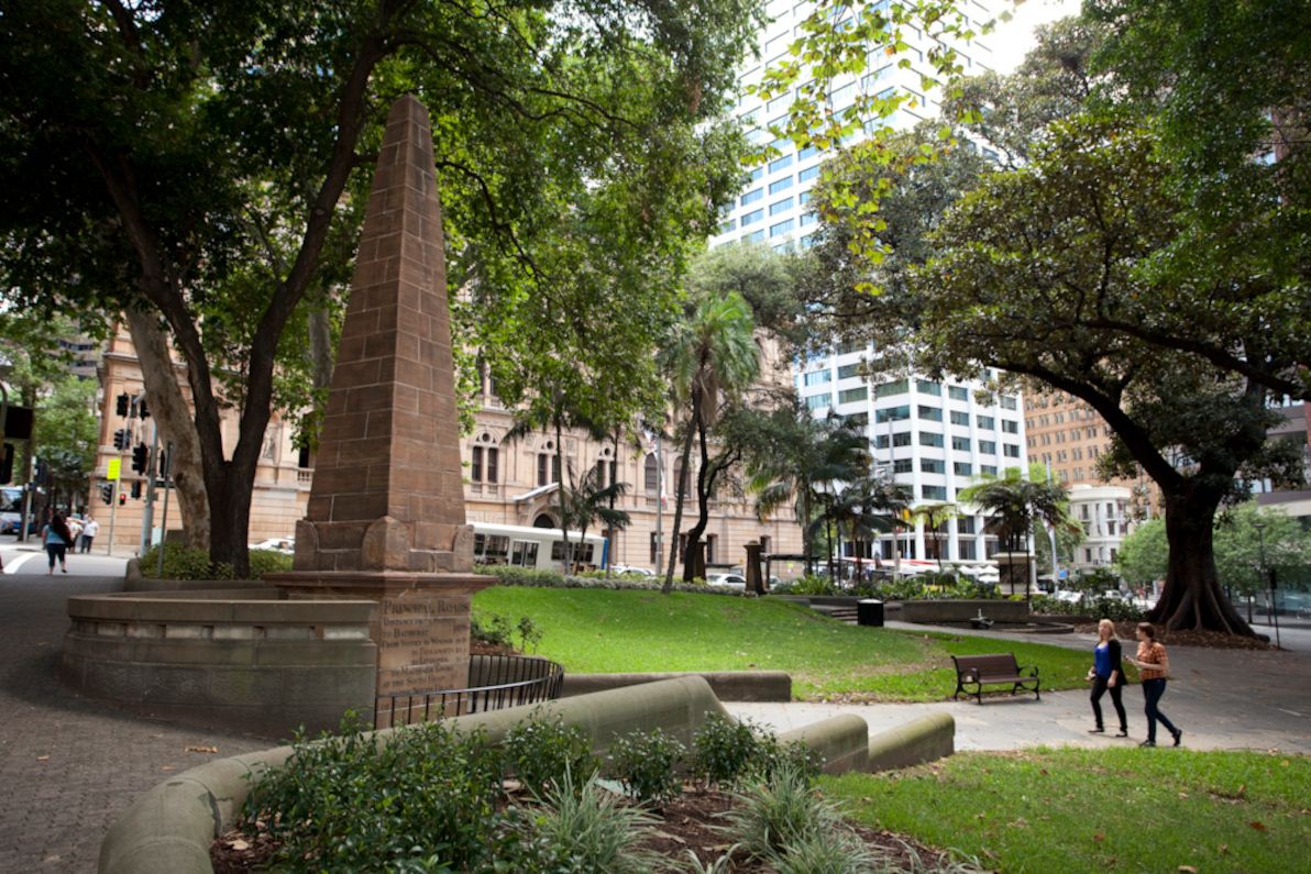
Macquarie Place
I've now covered the two spots that most people would likely think of as being the centre of Sydney, but which were never historically planned as such, and which "the powers that be" have never clearly proclaimed as such. The next candidate is a spot which was actually planned to be the official city centre (at least, as much as anything has ever been "planned" in Sydney), but which today finds itself at the edge of the CBD, and which few people have even heard of.
The New South Wales "Kilometre Zero" obelisk in Macquarie Place. Image source:City Art Sydney.
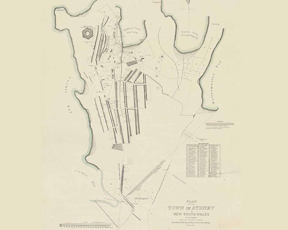
At the time, the area of Macquarie Place was the geographic centre of Sydney Town. The original colonial settlement clung to what is today Circular Quay, as all trade and transport with the rest of the world was via the shipping in Sydney Cove. The early town also remained huddled close to the Tank Stream, which ran between Pitt and George streets before discharging into the harbour (today the Tank Stream has been entirely relegated to a stormwater drain), and which was Sydney's sole fresh water supply for many years. The "hypotenuse" edge of Macquarie Place originally ran alongside the Tank Stream; indeed, the plaza's triangular shape was due to the Tank Stream fanning out into a muddy delta (all long gone and below the ground today) as it approached the harbour.
James Meehan's 1803 map of Sydney, with the original Tank Stream marked. Image source:National Library of Australia.
The most striking and significant feature of Macquarie Place is its large stone obelisk, which was erected in 1818, and which remains the official Kilometre Zero marker of Sydney and of NSW to this day. The obelisk lists the distances, in miles, to various towns in the greater Sydney region. As is inscribed in the stonework, its purpose is:
To record that all the Public Roads Leading to the Interior of the Colony are Measured from it.
So, if it's of such historical importance, why is Macquarie Place almost unheard-of by Sydney locals and visitors alike? Well, first and foremost, the fact is that it's no longer the geographical, cultural, or commercial heart of the city. That ship sailed south some time ago. Also, apart from its decline in fame, Macquarie Place has also suffered from being literally, physically eroded over the years. The size of the plaza was drastically reduced in the 1840s, when Loftus St was built to link Bridge St to Circular Quay, and the entire eastern half of Macquarie Place was lost. The relatively small space is now also dwarfed by the skyscrapers that loom over it on all sides.
Macquarie Place is today a humble, shady, tranquil park in the CBD's north, frequented by tour groups and by a few nearby office workers. It certainly doesn't feel like the centre of a city of over 4 million people. However, it was declared Sydney's "town square" when it was inaugurated, and no other spot has been declared its successor ever since. So, I'd say that if you ask a Sydney history buff, then he/she would surely have to concede that Macquarie Place remains the official city centre.
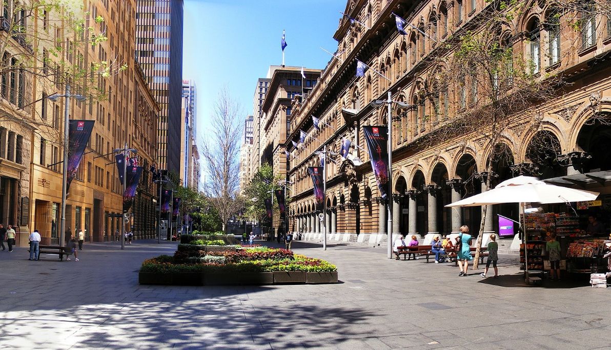
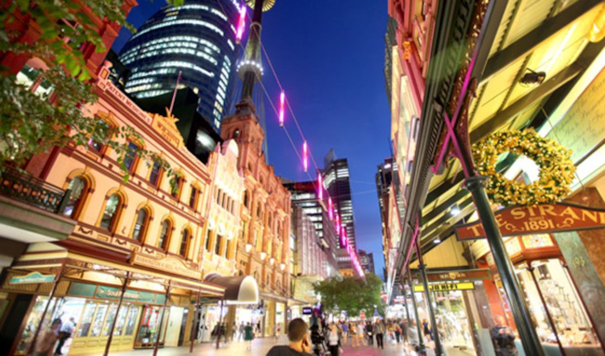
Pitt St Mall
With the top three candidates done, I'll now cover the other punters that might contend for centre stage in Sydney. However, I doubt that anyone would seriously considers these other spots to be in the running. I'm just listing them for completeness. First off is Pitt St Mall.
Sydney's central shopping precinct of Pitt St Mall, with Sydney Tower visibly adjacent to it. Image source:Structural & Civil Engineers.
Pitt St is one of the oldest streets in Sydney. However, there was never any plan for it to house a plaza. For much of its history (for almost 100 years), one of Sydney's busiest and longest-serving tram lines ran up its entire length. Since at least the late 1800s, the middle section of Pitt St – particularly the now pedestrian-only area between King and Market streets – has been Sydney's prime retail and fashion precinct. Some time in the late 1980s, this area was closed to traffic, and it's been known as Pitt St Mall ever since.
Pitt St Mall does actually tick several boxes as a contender for "official city centre". First and foremost, it is geographically the centre of Sydney's modern CBD, lying exactly in the middle between Martin Place and Town Hall. It's also home to Sydney Tower, the city's tallest structure. Plus, it's where the city's heaviest concentration of shops and of shopping centres can be found. However, the Mall has no real historical, cultural, or social significance. It exists purely to enhance the retail experience of the area.
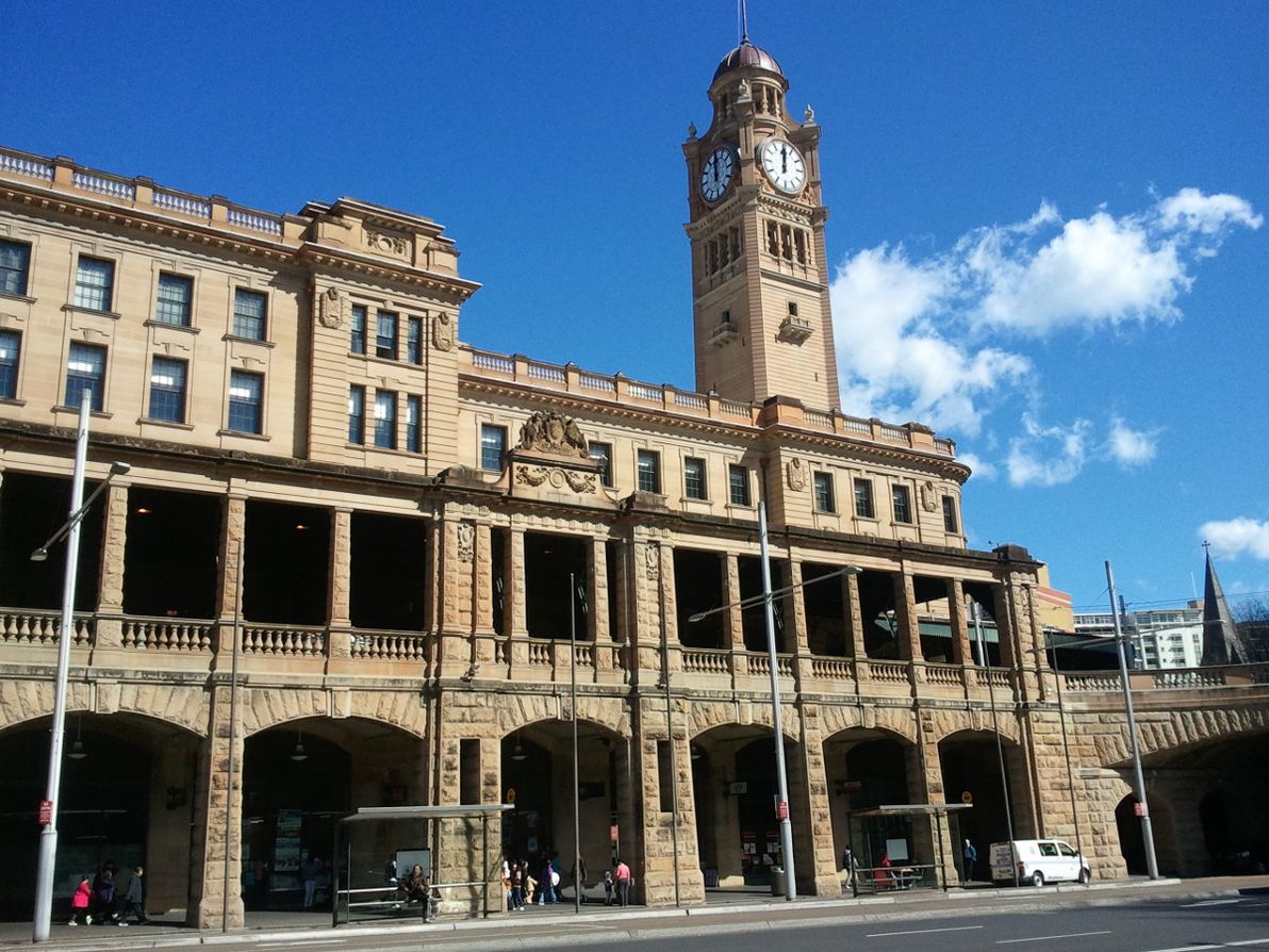
Central Station
Despite its name, Sydney's Central Railway Station is not in the middle of the city, but rather on the southern fringe of the CBD. Like its more centric cousin Town Hall, the site of Central Station was originally a cemetery (and the station itself was originally just south of its present location). Today, Central is Sydney's busiest passenger station. We Sydneysiders aren't taught in school that it's All Stations To Central for nothing.
Central Station as seen from adjacent Eddy Ave. Image source:Weekend Notes.
Central Station is the most geographically far-flung of the candidates listed in this article, and due to this, few people (if any) would seriously vote for it as Sydney's official centre. However, it does have some points in its favour. It is the city's main train station. Its Platform 1 is the official Kilometre Zero point of the NSW train network. And its clock tower dictates the official time of NSW trains (and, by extension, the official civil time in NSW).
Hyde Park
Although it's quite close to Town Hall and Pitt St Mall distance-wise, Hyde Park hugs the eastern edge of the Sydney CBD, rather than commanding centre stage. Inaugurated by Big Mac in 1810, together with Macquarie Place, Hyde Park is Sydney's oldest park, as well as its official main park.
Expansive view looking south-west upon Hyde Park. Image source:Floodslicer.
Macquarie's architect, Francis Greenway, envisaged Hyde Park eventually becoming Sydney's town square, however this never eventuated. Despite being Sydney's oldest park, present-day Hyde Park is also quite unrecognisable from its original form, having been completely re-designed and rebuilt several times. The obelisk at the head of Bathurst St, erected in 1857 (it's actually a sewer vent!), is probably the oldest artifact of the park that remains unchanged.
As well as being central Sydney's main green space, Hyde Park is also home to numerous important adjacent buildings, including St Mary's Cathedral (head of the Sydney Catholic Archdiocese), St James Church (the oldest church building in Sydney), the Supreme Court of NSW, and Hyde Park Barracks. Plus, Hyde Park boasts a colourful history, whose many anecdotes comprise an important part of the story of Sydney.
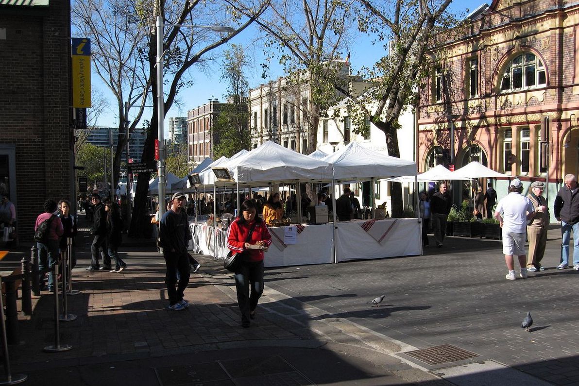
The Rocks Square
The place I'm referring to here doesn't even have a clearly-defined name. As far as I can tell, it's most commonly known as (The) Rocks Square, but it could also be called Clocktower Square (for the tower and shopping arcade adjacent to it), Argyle St Mall, Argyle St Market, or just "in front of The Argyle" (for the adjacent historic building and present-day nightclub). At any rate, I'm talking about the small, pedestrian-only area at the eastern end of Argyle St, in Sydney's oldest precinct, The Rocks.
Weekend markets at the eastern end of Argyle St, in The Rocks. Image source:David Ing.
This spot doesn't have a whole lot going for it. As I said, it's not even named properly, and it's not an official square or park of any sort. However, it's generally considered to be the heart of The Rocks, and in Sydney's earliest days it was the rough location of the city's social and economic centre. Immediately to the west of The Rocks Square, you can walk or drive through the Argyle Cut, which was the first major earth-moving project in Sydney's history. Today, The Rocks Square is a busy pedestrian thoroughfare, especially on weekends when the popular Rocks Markets are in full swing. And one thing that hasn't changed a bit since day one: there's no shortage of pubs, and other watering-holes, in and around this spot.
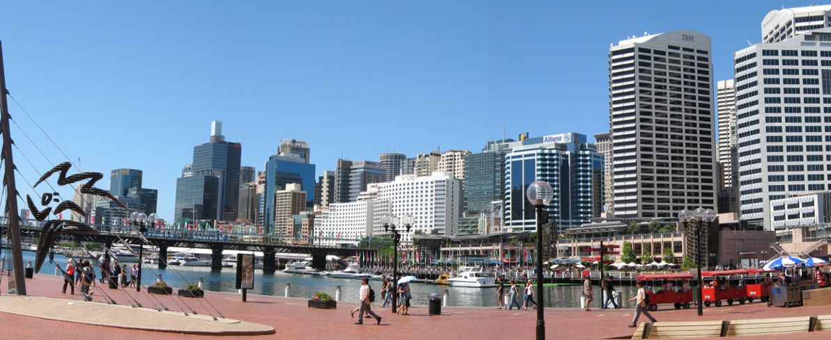
Darling Harbour
I'm only reluctantly including Darling Harbour on this list (albeit lucky last): clearly off to the west of the CBD proper, it's never been considered the "official centre" of Sydney by anyone. For much of its history, Darling Harbour was home to a collection of dirty, seedy dockyards that comprised the city's busiest port. The area was completely overhauled as the showpiece of Sydney's celebrations for the 1988 Australian Bicentennary celebrations. Since then, it's been one of Sydney's most popular tourist spots.
The centre of Darling Harbour, close the the IMAX Theatre. Image source:Wikimedia Commons.
Other than being a tourist trap, Darling Harbour's main claim to entitlement on this list is that it hosts the Sydney Convention Centre (the original centre was recently demolished, and is currently being rebuilt on a massive scale). The key pedestrian thoroughfare of Darling Harbour, just next to the IMAX Theatre (i.e. the spot in question for this list), is unfortunately situated directly below the Western Distributor, a large freeway that forms a roof of imposing concrete.
Final thoughts
Hope you enjoyed this little tour of the contenders for "official centre" of Sydney. Let me know if you feel that any other spots are worthy of being in the race. As for the winner: I selected what I believe are the three finalists, but I'm afraid I can't declare a clear-cut winner from among them. Purists would no doubt pick Macquarie Place, but in my opinion Martin Place and Town Hall present competition that can't be ignored.
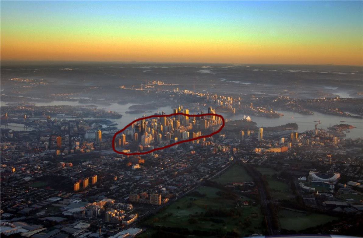
Sydney at sunset, with the city centre marked in dark red. Image source:SkyscraperCity.
Who knows? Perhaps the illustrious Powers That Be – in this case, the NSW Government and/or the Sydney City Council – will, in the near future, clarify the case once and for all. Then again, considering the difficulty of choice (as demonstrated in this article), and considering the modus operandi of the guv'ment around here, it will probably remain in the "too hard" basket for many years to come.
]]>
Non-Shelbyville Sydney map2010-05-15T00:00:00Z2010-05-15T00:00:00ZJazahttps://greenash.net.au/thoughts/2010/05/non-shelbyville-sydney-map/
A work colleague of mine recently made a colourful remark to someone. "You live in [boring outer suburb]?", she gasped. "That's so Shelbyville!" Interesting term, "Shelbyville". Otherwise known as "the 'burbs", or "not where the hip-hop folks live". Got me thinking. Where in Sydney is a trendy place for young 20-somethings to live, and where is Shelbyville?
I've lived in Sydney all my life. I've almost always lived quite squarely in Shelbyville myself. However, since the age of 18, I've gotten to know most of the popular nightlife haunts pretty well. And since entering the world of student share-houses, I've also become pretty familiar with the city's accommodation hotspots. So, having this background, and being a fan of online mapping funkiness, I decided to sit down and make a map of the trendiest spots in Sydney to live and play.
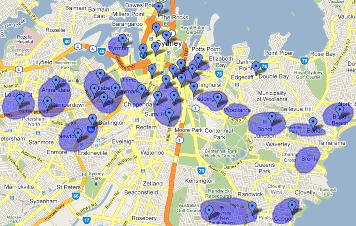
Map of non-Shelbyville Sydney
This map represents my opinion, and my opinion only. It's based on where I most commonly go out at night with my friends and colleagues, and on where my friends and colleagues live or have lived. I make no pretense: this map is biased, and any fellow Sydney-sider will no doubt have numerous criticisms of its inclusions and its omissions. If you wish to voice your qualms, feel free to leave a comment. I'll do my best to go through and justify the most controversial details of the map. But, in general, my justification is simply that "this is a map of my Sydney, so of course it's not going to be exactly the same as a map of your Sydney".
In this map, the coloured dots represent nightlife hotspots. In general, they represent exact streets or clusters of streets that are home to a number of bars, although some dots are pinpointing individual bars. The coloured regions represent accommodation hotspots. These regions should be thought of as covering a general area — usually a suburb or a group of neighbouring suburbs — rather than covering exact streets.
The nightlife hotspots and the accommodation hotspots almost always overlap. You could say that one defines the other, and vice versa. The main exception to this rule is the Sydney CBD (i.e. George St, Martin Place, and Darling Harbour), which has the biggest nightlife concentration of anywhere, but which has almost no permanent accommodation, apart from a few recently-built towering monstrosities (and I wouldn't consider them trendy, as they're super-pricey and utterly soulless). There are a few other exceptions, which I'll get to shortly.
As you can see, the map is concentrated around the city centre, the Inner West, and the Eastern Suburbs. As a (recently-graduated) Uni student and a young professional, these are the areas that are almost exclusively on my radar these days.
The trendy areas
Inner West. Glebe, Newtown, Annandale and Leichhardt are the heart of where to stay and where to party in the Inner West. In particular, Newtown — the hippie student capital of Sydney — is one of my most frequent night hangouts. The suburbs surrounding Newtown (e.g. Erskineville, Stanmore) are also great places to live, although I can't say I party in those places myself.
Around City Centre. Surry Hills is on the CBD's doorstep, and it's a very trendy place both for living and for partying. Surry Hills is also where I work, so I've inevitably been frequenting many of its watering-holes of late. Ultimo and Chippendale are also close to my heart, as that's the neighbourhood of my old uni. At the last minute, I included Pyrmont, as it has nice accommodation these days; however, its only real night attraction is the casino, and casinos ain't particularly my thing. The Rocks is special, because it's a really good place to go out for drinks, but it's basically inside the CBD, and I don't know anyone who actually lives there. I reluctantly decided to include Darlinghurst and The Cross, as they're becoming increasingly hip places of abode — and they're also home to Sydney's most intense all-night party joints — but personally, I don't go out to that area at night, and I don't see the attraction of living next door to hookers and crack junkies.
Eastern Suburbs. Much of the East is overpriced beyond trendy standards, and/or is suburban Shelbyville. I've identified five main spots that go (more-or-less) in a line between City and Surf, and that aren't in this category: Paddington, Woollahra, Bondi Junction, Bondi, and Bondi Beach. Woollahra doesn't offer much nightlife itself, but its location between Paddington and The Jungo means that plenty of choice is nearby. Double Bay has some decent bars come evening-time, but considering that the only person I know who lives there is my Grandma, I can't really call it a trendy place to live. Bronte is a bit of a special case: I've never been out there at night, and I don't think it has much in the way of bars, but I know quite a few people that have lived there; plus, it really is a lovely beach. Coogee is actually the most remote place (from the city) that made it on the map, but there's no way I could have left it out. Also, the Randwick / UNSW area probably doesn't seriously qualify as a trendy spot; but because so many of my friends study at and/or live near UNSW, it qualifies for me.
Sorry, it's Shelbyville
Balmain. Also surrounding suburbs (i.e. Rozelle, Lilyfield, Drummoyne). I know that plenty of young and trendy people live and hang out in these places. But personally, I don't know anyone who lives in these areas, and I've never been out to them at night.
Harbour bays in the East. This mainly includes Elizabeth Bay, Rose Bay, and Watsons Bay. I know they all have some decent night hangouts. But all of them are also luxury suburbs, not for mere mortals; I for one don't have any friends living in those places.
Manly. I know that Manly people will never forgive me for this. I also know that Manly is a super-cool place both to live and to hang out. But I'm sorry — it's just too far from everywhere else! This is why people in non-Shelbyville Sydney, whether justified or not, call Manly Shelbyville.
Lower North Shore. North Sydney, Crows Nest, Neutral Bay, and Mosman. All Shelbyville. I'm a North Shore boy, so having lived there, and having now moved out into the real world, I should know. Yes, there are bars in all these suburbs. But does anyone from out of the area actually go to them? And would anyone actually move to these areas in order to be "where the action is"? No.
Everywhere else in Sydney is well and truly Shelbyville. My home through the teenage years — the mid North Shore around Chatswood and Gordon — is Shelbyville. No questions asked. My current abode — the Strathfield and Burwood area — is Shelbyville. No exception. The Shire is Shelbyville. Rockdale / Brighton is Shelbyville. Maroubra is Shelbyville. The Northern Beaches are Shelbyville. Parramatta is Shelbyville. And the Rest of the West is so daym Shelbyville it's not funny.
Further reading
Some sources that I used to get a feel for different opinions about Sydney's cool corners: